– Lat/Long: 44.96° N 6.22° E
 Aiguille du Plat de la Selle
Weather Forecast, FranceIssued: 1 pm Mon 03 Aug Local TimeUpdates in: hr min sUpdate imminent
Issued: 1 pm Mon 03 Aug Local Time
Updates in:
Update imminent hr min s

Issued: 1 pm Mon 03 Aug Local Time
Updates in:
Update imminent hr min s
Days 1–4 Weather SummaryModerate rain (total 11mm), heaviest on Tue night. Very mild (max 12°C on Mon afternoon, min 8°C on Wed morning). Wind will be generally light. | Days 5–7 Weather SummaryLight rain (total 6mm), mostly falling on Thu afternoon. Very mild (max 11°C on Sat afternoon, min 8°C on Thu night). Wind will be generally light. | ||||||||||||||||
Mon 3 | Tuesday 4 | Wednesday 5 | Thursday 6 | Friday 7 | Saturday 8 | ||||||||||||
PM | night | AM | PM | night | AM | PM | night | AM | PM | night | AM | PM | night | AM | PM | night | |
rain shwrs | risk tstorm | clear | rain shwrs | rain shwrs | clear | rain shwrs | risk tstorm | some clouds | risk tstorm | rain shwrs | clear | rain shwrs | risk tstorm | clear | clear | clear | |
Cloud base (m) | 3800 | 4300 | 4750 | 4050 | 4500 | 3300 | 6250 | 2450 | 3500 | ||||||||
km/h | |||||||||||||||||
 |  |  |  |  |  | ||||||||||||
— | — | — | — | — | — | — | — | — | — | — | — | — | — | — | — | — | |
mm | 0.1 | 0.5 | — | 0.6 | 8 | — | 1.1 | 1.3 | — | 5 | 1.3 | — | 0.3 | 0.3 | — | — | — |
max °C | 12 | 11 | 10 | 11 | 9 | 9 | 11 | 10 | 10 | 9 | 9 | 9 | 10 | 9 | 9 | 11 | 10 |
min °C | 12 | 10 | 10 | 11 | 9 | 8 | 10 | 10 | 9 | 9 | 8 | 9 | 9 | 9 | 9 | 10 | 10 |
chill °C | 11 | 8 | 8 | 9 | 8 | 8 | 10 | 10 | 9 | 8 | 8 | 9 | 9 | 9 | 9 | 10 | 10 |
Freezing level m | 4700 | 4500 | 4500 | 4500 | 4500 | 4350 | 4500 | 4500 | 4400 | 4450 | 4350 | 4350 | 4450 | 4400 | 4400 | 4550 | 4550 |
— | — | 6:22 | — | — | 6:24 | — | — | 6:24 | — | — | 6:26 | — | — | 6:26 | — | — | |
— | 8:59 | — | — | 8:58 | — | — | 8:57 | — | — | 8:54 | — | — | 8:53 | — | — | 8:52 | |
Loading...
Aiguille du Plat de la Selle Weather (Days 0-3):
The weather forecast for Aiguille du Plat de la Selle is: Moderate rain (total 11mm), heaviest on Tue night. Very mild (max 12°C on Mon afternoon, min 8°C on Wed morning). Wind will be generally light.
Aiguille du Plat de la Selle Weather (Days 3-6):
Light rain (total 6mm), mostly falling on Thu afternoon. Very mild (max 11°C on Sat afternoon, min 8°C on Thu night). Wind will be generally light.
This table gives the weather forecast for Aiguille du Plat de la Selle at the specific elevation of 3000 m. Our advanced weather models allow us to provide distinct weather forecasts for several elevations of Aiguille du Plat de la Selle. To see the weather forecasts for the other elevations, use the tab navigation above the table. For a wider overview of the weather, consult the Weather Map of France.
| Weather Station | Temp. | Weather | Wind | Gusts | Cloud / Visibility |
|---|---|---|---|---|---|
lightning 13km W of Saint-Martin-de-Queyrieres | |||||
TC Montfrais g4 | |||||
TMX clos giraud g2 | |||||
Villar Saint Pancrace | |||||
thunderstorm affecting Saint-Michel-de-Maurienne | |||||
Devoluy Altisurface | |||||
lightning 9km WNW of Embrun | |||||
lightning 10km NNE of Chorges | |||||
lightning 8km NE of Saint-Jean-de-Maurienne | |||||
1309 |
* NOTE: not all weather observatories update at the same frequency which is the reason why some locations may show data from stations that are further away than known closer ones.
Aiguille du Plat de la Selle Photos
View all
Dauphine Alps photos (34) |
Alps photos (1485) |
photos from mountains in France (302) |
all photos
 Upload new photo
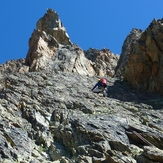
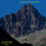
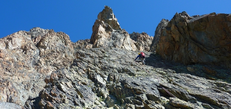
Aiguille du plat de la selle lg 24 "Les sources du silence" malain
Aiguille du plat de la selle face S "Les sources du silence" by malain
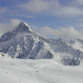
Aiguille du Plat de la Selle