– Lat/Long: 36.58° N 118.29° W
 Mount Whitney
Weather Forecast, United StatesIssued: 4 pm Sun 02 Aug Local TimeUpdates in: hr min sUpdate imminent
Issued: 4 pm Sun 02 Aug Local Time
Updates in:
Update imminent hr min s

Issued: 4 pm Sun 02 Aug Local Time
Updates in:
Update imminent hr min s
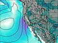
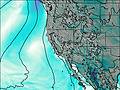
Days 1–4 Weather SummaryMostly dry. Warm (max 26°C on Sun afternoon, min 21°C on Sun night). Wind will be generally light. | Days 5–7 Weather SummaryMostly dry. Warm (max 26°C on Fri afternoon, min 21°C on Wed night). Wind will be generally light. | ||||||||||||||||
Sun 2 | Monday 3 | Tuesday 4 | Wednesday 5 | Thursday 6 | Friday 7 | ||||||||||||
PM | night | AM | PM | night | AM | PM | night | AM | PM | night | AM | PM | night | AM | PM | night | |
clear | clear | clear | clear | clear | clear | clear | clear | clear | some clouds | clear | clear | some clouds | clear | clear | cloudy | clear | |
Cloud base (m) | 9800 | 6300 | 5950 | 5550 | |||||||||||||
km/h | |||||||||||||||||
 |  |  |  |  |  | ||||||||||||
— | — | — | — | — | — | — | — | — | — | — | — | — | — | — | — | — | |
mm | — | — | — | — | — | — | — | — | — | — | — | — | — | — | — | — | — |
max °C | 26 | 22 | 24 | 25 | 23 | 24 | 25 | 23 | 24 | 25 | 22 | 24 | 25 | 23 | 24 | 26 | 23 |
min °C | 26 | 21 | 21 | 25 | 21 | 22 | 25 | 21 | 22 | 25 | 21 | 22 | 25 | 21 | 22 | 25 | 21 |
chill °C | 26 | 21 | 21 | 25 | 21 | 22 | 25 | 21 | 22 | 25 | 21 | 22 | 25 | 21 | 22 | 25 | 21 |
Freezing level m | 5850 | 5650 | 5600 | 5750 | 5600 | 5600 | 5750 | 5600 | 5600 | 5700 | 5550 | 5550 | 5650 | 5550 | 5600 | 5650 | 5500 |
— | — | 6:00 | — | — | 6:01 | — | — | 6:01 | — | — | 6:03 | — | — | 6:03 | — | — | |
7:58 | — | — | 7:57 | — | — | 7:55 | — | — | 7:54 | — | — | 7:53 | — | — | 7:52 | — | |
Loading...
Mount Whitney Weather (Days 0-3):
The weather forecast for Mount Whitney is: Mostly dry. Warm (max 26°C on Sun afternoon, min 21°C on Sun night). Wind will be generally light.
Mount Whitney Weather (Days 3-6):
Mostly dry. Warm (max 26°C on Fri afternoon, min 21°C on Wed night). Wind will be generally light.
This table gives the weather forecast for Mount Whitney at the specific elevation of 2500 m. Our advanced weather models allow us to provide distinct weather forecasts for several elevations of Mount Whitney. To see the weather forecasts for the other elevations, use the tab navigation above the table. For a wider overview of the weather, consult the Weather Map of California.
| Weather Station | Temp. | Weather | Wind | Gusts | Cloud / Visibility |
|---|---|---|---|---|---|
Bishop Airport | |||||
Visalia Municipal Airport | |||||
Hanford Airport | |||||
Delano Airport (California) | |||||
Fresno Chandler |
* NOTE: not all weather observatories update at the same frequency which is the reason why some locations may show data from stations that are further away than known closer ones.
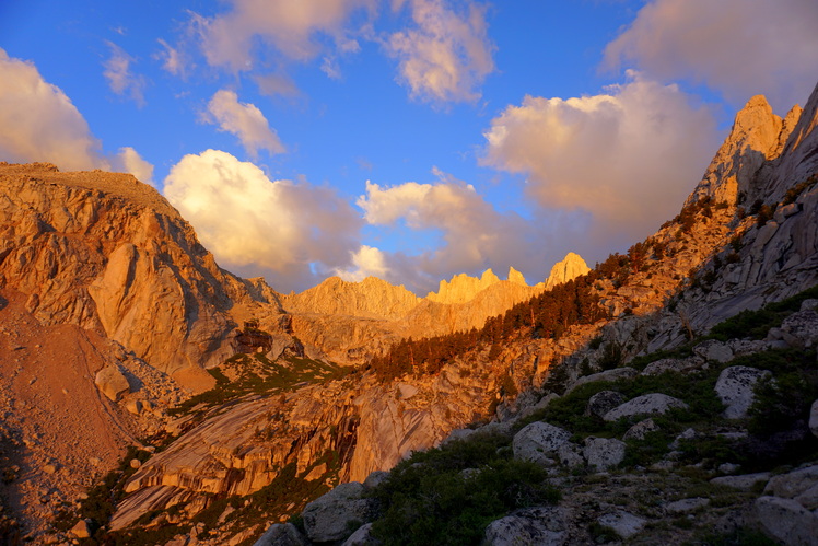
Mount Whitney Photos
View all
photos (140) |
Sierra Nevada photos (212) |
photos from mountains in United States (3056) |
all photos
 Upload new photo
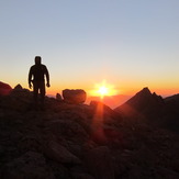

 See 67 more Mount Whitney photos
Anthony Fiore, Mountaineer's Route, Mount Whitney
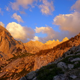
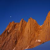
Mount Whitney Alpenglow
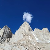
Mount Whitney
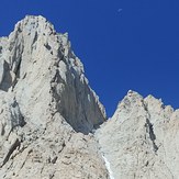
Mount Whitney mountaineers route
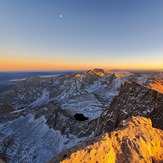
Sunrise, from camp on the Mountaineers Route
Sunset