– Lat/Long: 36.58° N 118.29° W

UsMount Whitney – Climbing, Hiking & Mountaineering information

Placeholder

Mount Whitney mountain guide

Mount Whitney mountaineers route photo

Mount Whitney

Photo credit: Scott Hemingway

October 2012, Mount Whitney photo

Mount Whitney

Photo credit: Brian Janey

Mount Whitney Summit photo

Mount Whitney

Photo credit: Richard

Mount Whitney photo

Mount Whitney

Photo credit: Geographer

Mount Whitney Alpenglow photo

Mount Whitney

Photo credit: Tony Ramos

Mount Whitney and the Needles photo

Mount Whitney

Photo credit: Karl Helser

  • Elevation: 4418 m
  • Difficulty: Walk up
  • Best months to climb: June, July, August, September
  • Convenient center: Whitney Portal, California (east of the mountain)

Mount Whitney Climbing Notes

Laguna Hiker from UNITED STATES writes:

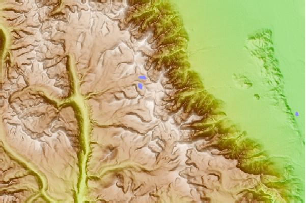
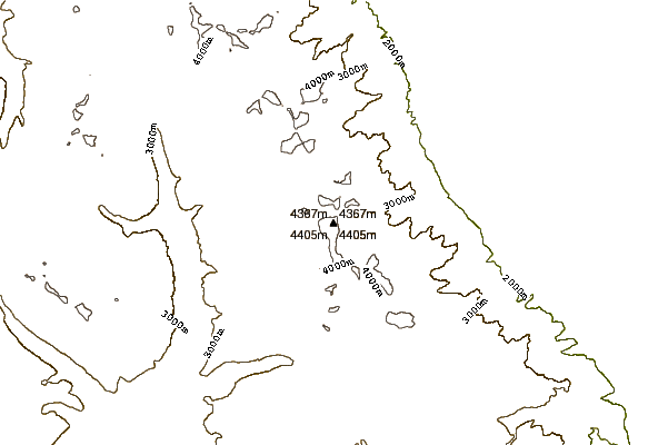
Notes from a three-time summiter:

Micro-spikes: If you're going up the Portal Trail, by al means, bring them along, along with a pair of hiking poles. They may come in very handy. But if you come across seriously icy conditions, turn around! The mountain will still be there next year.

If you are climbing the Mountaineer's Route, though, micro-spikes won't help. Crampons and ice axe are in order there, as well as experience in using them.

Altitude sickness: Take it seriously--it isn't just dehydration or poor nutrition. Two hazards: Edema, which can be life-life-threatening, and hypoxia, which impairs judgment.

If you become nauseated or throw up, do not continue your ascent; you are one step away from edema. Go back down at least 1500 feet, more if still nauseated.

And assume before you go up that your judgment will be impaired by hypoxia, because it will. You will hike the Summit Trail as if you had just downed several shots of tequila. So be extra cautious, and take your time on your way to and from the summit. Hypoxia has convinced people they can make it across a long icy patch, with fatal results. Be hyper-cautious!

Drink as much water as you can in the 48 hours before you start the climb--it will help hold altitude sickness (but not hypoxia) at bay.

2015-08-02

Click here to read 9 more climbing notes for Mount Whitney or submit your own

Mount Whitney Location Map

Select Mount Whitney Location Map Detail:


Latest Gallery Images for Mount Whitney

visit the
gallery
or click to view
Anthony Fiore, Mountaineer's Route, Mount WhitneyMount WhitneySunrise, from camp on the Mountaineers RouteMount Whitney

Upload your photo of Mount Whitney

Select a mountain summit from the menu
Select a Mountain Summit
Surf breaks located close to Mount Whitney Mountain peaks around Mount Whitney Roads and rivers around Mount Whitney

Use this relief map to navigate to mountain peaks in the area of Mount Whitney.

10 other mountain peaks closest to Mount Whitney:

1. Mount Russell (4293 m) 1.3 km
2. Mount Muir (4271 m) 1.6 km
3. Mount McAdie (4206 m) 3.5 km
4. Mount Irvine (4241 m) 3.7 km
5. Mount Mallory (4220 m) 4.2 km
6. Mount Le Conte (California) (4246 m) 5.6 km
7. Mount Barnard (4264 m) 6.1 km
8. Lone Pine Peak (3945 m) 6.4 km
9. Mount Langley (4275 m) 7.0 km
10. Keeler Needle (4347 m) 7.9 km