
– Lat/Long: 45.98° N 7.42° E
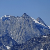
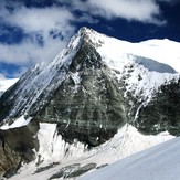
 Mont Blanc de Cheilon
Weather Forecast, SwitzerlandIssued: 7 pm Wed 01 Jul Local TimeUpdates in: hr min sUpdate imminent
Issued: 7 pm Wed 01 Jul Local Time
Updates in:
Update imminent hr min s

Issued: 7 pm Wed 01 Jul Local Time
Updates in:
Update imminent hr min s
Days 1–4 Weather SummaryMostly dry. Freeze-thaw conditions (max 2°C on Thu night, min -4°C on Wed night). Winds decreasing (strong winds from the N on Wed night, light winds from the WNW by Fri night). | Days 5–7 Weather SummaryMostly dry. Freeze-thaw conditions (max 3°C on Mon afternoon, min 0°C on Sat night). Wind will be generally light. | ||||||||||||||||||
Thursday 2 | Friday 3 | Saturday 4 | Sunday 5 | Monday 6 | Tuesday 7 | ||||||||||||||
night | AM | PM | night | AM | PM | night | AM | PM | night | AM | PM | night | AM | PM | night | AM | PM | night | |
clear | clear | clear | clear | clear | some clouds | clear | clear | clear | clear | clear | clear | clear | clear | clear | clear | clear | clear | clear | |
km/h | |||||||||||||||||||
 |  |  |  |  |  |  | |||||||||||||
— | — | — | — | — | — | — | — | — | — | — | — | — | — | — | — | — | — | — | |
mm | — | — | — | — | — | — | — | — | — | — | — | — | — | — | — | — | — | — | — |
max °C | 0 | 1 | 1 | 2 | 1 | 2 | 2 | 1 | 2 | 2 | 2 | 2 | 1 | 1 | 3 | 2 | 1 | 3 | 2 |
min °C | -4 | 0 | 1 | 0 | 0 | 1 | 1 | 1 | 2 | 0 | 1 | 1 | 0 | 1 | 2 | 1 | 1 | 3 | 2 |
chill °C | -13 | -5 | -4 | -5 | -5 | -4 | -4 | -2 | -2 | -5 | -4 | -4 | -6 | -4 | -3 | -4 | -4 | -2 | -3 |
Freezing level m | 3400 | 3950 | 4050 | 4200 | 4000 | 4200 | 4150 | 4050 | 4100 | 4150 | 4050 | 4150 | 4000 | 4000 | 4250 | 4100 | 4100 | 4400 | 4250 |
Cloud base (m) | 2900 | 3700 | 2900 | 4150 | 9550 | 4200 | 9450 | ||||||||||||
— | 5:43 | — | — | 5:43 | — | — | 5:45 | — | — | 5:45 | — | — | 5:46 | — | — | 5:47 | — | — | |
— | — | — | 9:23 | — | — | 9:23 | — | — | 9:23 | — | — | 9:22 | — | — | 9:22 | — | — | 9:22 | |
Loading...
Mont Blanc de Cheilon Weather (Days 0-3):
The weather forecast for Mont Blanc de Cheilon is: Mostly dry. Freeze-thaw conditions (max 2°C on Thu night, min -4°C on Wed night). Winds decreasing (strong winds from the N on Wed night, light winds from the WNW by Fri night).
Mont Blanc de Cheilon Weather (Days 3-6):
Mostly dry. Freeze-thaw conditions (max 3°C on Mon afternoon, min 0°C on Sat night). Wind will be generally light.
This table gives the weather forecast for Mont Blanc de Cheilon at the specific elevation of 3870 m. Our advanced weather models allow us to provide distinct weather forecasts for several elevations of Mont Blanc de Cheilon. To see the weather forecasts for the other elevations, use the tab navigation above the table. For a wider overview of the weather, consult the Weather Map of Switzerland.
Mont Blanc de Cheilon Photos
View all
Pennine Alps photos (202) |
Alps photos (1484) |
photos from mountains in Switzerland (649) |
all photos
 Upload new photo
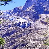
Znikający lodowiec w Szwajcarii
Mont Blanc de Cheilon
Mont Blanc de Cheilon