
– Lat/Long: 45.98° N 7.42° E
 Mont Blanc de Cheilon
Weather Forecast, SwitzerlandIssued: 1 pm Mon 03 Aug Local TimeUpdates in: hr min sUpdate imminent
Issued: 1 pm Mon 03 Aug Local Time
Updates in:
Update imminent hr min s

Issued: 1 pm Mon 03 Aug Local Time
Updates in:
Update imminent hr min s
Days 1–4 Weather SummaryHeavy rain (total 23mm), heaviest during Wed night. Warm (max 26°C on Mon afternoon, min 21°C on Mon night). Wind will be generally light. | Days 5–7 Weather SummaryModerate rain (total 16mm), heaviest on Thu night. Warm (max 25°C on Thu afternoon, min 18°C on Thu night). Wind will be generally light. | ||||||||||||||||
Mon 3 | Tuesday 4 | Wednesday 5 | Thursday 6 | Friday 7 | Saturday 8 | ||||||||||||
PM | night | AM | PM | night | AM | PM | night | AM | PM | night | AM | PM | night | AM | PM | night | |
risk tstorm | risk tstorm | rain shwrs | risk tstorm | rain shwrs | clear | rain shwrs | rain shwrs | clear | risk tstorm | rain shwrs | clear | risk tstorm | rain shwrs | clear | rain shwrs | rain shwrs | |
Cloud base (m) | 4600 | 6850 | 4600 | 4350 | 4450 | 3500 | 2800 | ||||||||||
km/h | |||||||||||||||||
 |  |  |  |  |  | ||||||||||||
— | — | — | — | — | — | — | — | — | — | — | — | — | — | — | — | — | |
mm | 0.9 | 3 | 0.1 | 3 | 4 | — | 4 | 8 | — | 4 | 8 | — | 1.6 | 0.6 | — | 1.3 | 0.3 |
max °C | 26 | 22 | 24 | 26 | 23 | 24 | 25 | 21 | 24 | 25 | 20 | 22 | 24 | 21 | 23 | 25 | 22 |
min °C | 25 | 21 | 21 | 25 | 21 | 21 | 23 | 21 | 22 | 21 | 18 | 18 | 23 | 19 | 19 | 25 | 20 |
chill °C | 25 | 21 | 21 | 25 | 21 | 21 | 23 | 21 | 22 | 21 | 18 | 18 | 23 | 19 | 19 | 25 | 20 |
Freezing level m | 4500 | 4450 | 4400 | 4500 | 4450 | 4450 | 4500 | 4400 | 4400 | 4300 | 4150 | 4200 | 4300 | 4200 | 4300 | 4450 | 4350 |
— | — | 6:15 | — | — | 6:16 | — | — | 6:16 | — | — | 6:18 | — | — | 6:20 | — | — | |
— | 8:58 | — | — | 8:55 | — | — | 8:54 | — | — | 8:52 | — | — | 8:52 | — | — | 8:50 | |
Loading...
Mont Blanc de Cheilon Weather (Days 0-3):
The weather forecast for Mont Blanc de Cheilon is: Heavy rain (total 23mm), heaviest during Wed night. Warm (max 26°C on Mon afternoon, min 21°C on Mon night). Wind will be generally light.
Mont Blanc de Cheilon Weather (Days 3-6):
Moderate rain (total 16mm), heaviest on Thu night. Warm (max 25°C on Thu afternoon, min 18°C on Thu night). Wind will be generally light.
This table gives the weather forecast for Mont Blanc de Cheilon at the specific elevation of 1000 m. Our advanced weather models allow us to provide distinct weather forecasts for several elevations of Mont Blanc de Cheilon. To see the weather forecasts for the other elevations, use the tab navigation above the table. For a wider overview of the weather, consult the Weather Map of Switzerland.
| Weather Station | Temp. | Weather | Wind | Gusts | Cloud / Visibility |
|---|---|---|---|---|---|
lightning 10km NW of Valtournenche | |||||
lightning 10km SE of Evolene | |||||
Evolène | |||||
Evolene / Villa | |||||
Evolène Servacresse | |||||
Les Attelas | |||||
Evolène La Vieille | |||||
Croix de Cœur | |||||
Montagnier- Bagnes |
* NOTE: not all weather observatories update at the same frequency which is the reason why some locations may show data from stations that are further away than known closer ones.
Mont Blanc de Cheilon Photos
View all
Pennine Alps photos (202) |
Alps photos (1485) |
photos from mountains in Switzerland (649) |
all photos
 Upload new photo
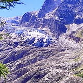
Znikający lodowiec w Szwajcarii
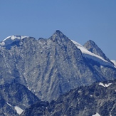
Mont Blanc de Cheilon
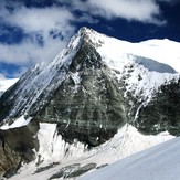
Mont Blanc de Cheilon