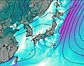
– Lat/Long: 36.15° N 136.78° E
 Haku-san
Weather Forecast, JapanIssued: 2 pm Mon 03 Aug Local TimeUpdates in: hr min sUpdate imminent
Issued: 2 pm Mon 03 Aug Local Time
Updates in:
Update imminent hr min s

Issued: 2 pm Mon 03 Aug Local Time
Updates in:
Update imminent hr min s
Days 1–4 Weather SummaryModerate rain (total 19mm), heaviest on Mon afternoon. Very mild (max 19°C on Wed morning, min 16°C on Mon night). Wind will be generally light. | Days 5–7 Weather SummaryHeavy rain (total 34mm), heaviest during Sat afternoon. Very mild (max 18°C on Thu afternoon, min 16°C on Sat night). Wind will be generally light. | ||||||||||||||||
Mon 3 | Tuesday 4 | Wednesday 5 | Thursday 6 | Friday 7 | Saturday 8 | ||||||||||||
PM | night | AM | PM | night | AM | PM | night | AM | PM | night | AM | PM | night | AM | PM | night | |
risk tstorm | rain shwrs | rain shwrs | risk tstorm | rain shwrs | rain shwrs | risk tstorm | rain shwrs | risk tstorm | risk tstorm | rain shwrs | rain shwrs | risk tstorm | rain shwrs | risk tstorm | risk tstorm | rain shwrs | |
Cloud base (m) | 950 | 1600 | 900 | 850 | 800 | 1750 | 1800 | 2050 | 2050 | 1550 | 2100 | 2050 | |||||
km/h | |||||||||||||||||
 |  |  |  |  |  | ||||||||||||
— | — | — | — | — | — | — | — | — | — | — | — | — | — | — | — | — | |
mm | 9 | 0.8 | 2 | 3 | 1.1 | 1 | 1.2 | 0.4 | 0.9 | 4 | 0.2 | 0.4 | 4 | 0.9 | 6 | 13 | 1.1 |
max °C | 18 | 17 | 17 | 17 | 17 | 19 | 18 | 18 | 19 | 18 | 17 | 18 | 18 | 17 | 17 | 17 | 16 |
min °C | 18 | 16 | 16 | 17 | 16 | 16 | 18 | 17 | 18 | 18 | 17 | 17 | 18 | 17 | 17 | 17 | 16 |
chill °C | 18 | 16 | 16 | 17 | 16 | 16 | 18 | 17 | 18 | 18 | 17 | 17 | 18 | 17 | 17 | 17 | 16 |
Freezing level m | 5600 | 5650 | 5450 | 5500 | 5450 | 5500 | 5350 | 5450 | 5350 | 5350 | 5400 | 5350 | 5200 | 5300 | 5200 | 5100 | 5050 |
— | — | 5:01 | — | — | 5:01 | — | — | 5:03 | — | — | 5:03 | — | — | 5:05 | — | — | |
6:55 | — | — | 6:54 | — | — | 6:53 | — | — | 6:52 | — | — | 6:52 | — | — | 6:51 | — | |
Loading...
Haku-san Weather (Days 0-3):
The weather forecast for Haku-san is: Moderate rain (total 19mm), heaviest on Mon afternoon. Very mild (max 19°C on Wed morning, min 16°C on Mon night). Wind will be generally light.
Haku-san Weather (Days 3-6):
Heavy rain (total 34mm), heaviest during Sat afternoon. Very mild (max 18°C on Thu afternoon, min 16°C on Sat night). Wind will be generally light.
This table gives the weather forecast for Haku-san at the specific elevation of 2000 m. Our advanced weather models allow us to provide distinct weather forecasts for several elevations of Haku-san. To see the weather forecasts for the other elevations, use the tab navigation above the table. For a wider overview of the weather, consult the Weather Map of Japan.
| Weather Station | Temp. | Weather | Wind | Gusts | Cloud / Visibility |
|---|---|---|---|---|---|
Komatsu Airport | |||||
lightning 19km E of Gujo | |||||
lightning 27km NNE of Minokamo | |||||
lightning 27km NW of Nakatsugawa | |||||
lightning 17km NNE of Mitake | |||||
lightning 18km N of Mizunami |
* NOTE: not all weather observatories update at the same frequency which is the reason why some locations may show data from stations that are further away than known closer ones.
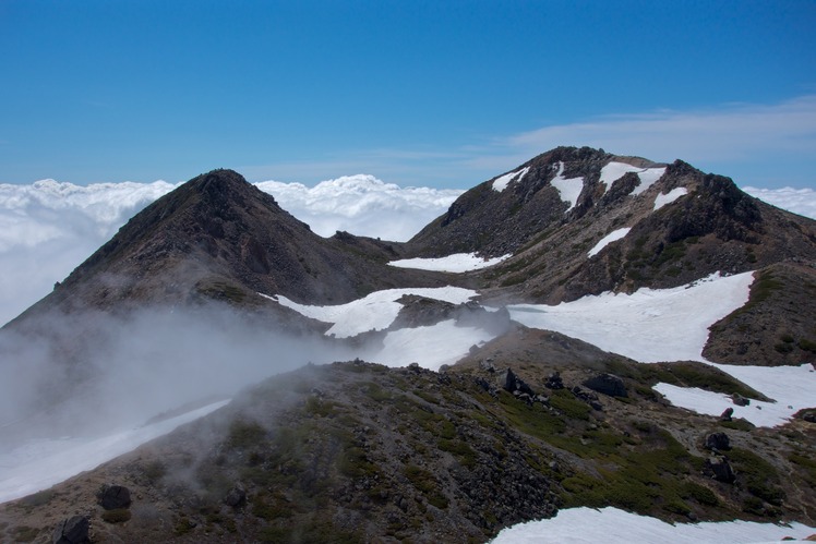
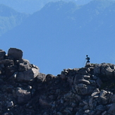
Haku-san Photos
View all
Ryōhaku Mountains photos (14) |
Japanese Archipelago photos (294) |
photos from mountains in Japan (376) |
all photos
 Upload new photo
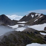
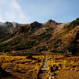
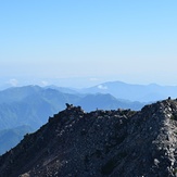
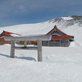
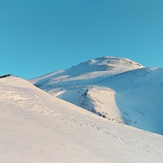
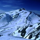 See 8 more Haku-san photos
Haku-san
白山
Mount hakusan-kengamine Trail running
hakusan kengamine
Mount Haku-san
Haku-san