– Lat/Long: 46.05° N 6.83° E
 Grenier de Commune
Weather Forecast, FranceIssued: 1 pm Mon 03 Aug Local TimeUpdates in: hr min sUpdate imminent
Issued: 1 pm Mon 03 Aug Local Time
Updates in:
Update imminent hr min s

Issued: 1 pm Mon 03 Aug Local Time
Updates in:
Update imminent hr min s
Days 1–4 Weather SummaryHeavy rain (total 31mm), heaviest during Tue afternoon. Warm (max 29°C on Mon afternoon, min 19°C on Tue night). Wind will be generally light. | Days 5–7 Weather SummaryModerate rain (total 11mm), heaviest on Thu afternoon. Warm (max 25°C on Sat afternoon, min 17°C on Thu night). Wind will be generally light. | ||||||||||||||||
Mon 3 | Tuesday 4 | Wednesday 5 | Thursday 6 | Friday 7 | Saturday 8 | ||||||||||||
PM | night | AM | PM | night | AM | PM | night | AM | PM | night | AM | PM | night | AM | PM | night | |
rain shwrs | risk tstorm | rain shwrs | risk tstorm | rain shwrs | clear | risk tstorm | risk tstorm | rain shwrs | mod. rain | rain shwrs | clear | risk tstorm | rain shwrs | clear | clear | clear | |
Cloud base (m) | 2350 | 9700 | 5800 | 2200 | 4350 | 3100 | 2450 | 2050 | 2600 | ||||||||
km/h | |||||||||||||||||
 |  |  |  |  |  | ||||||||||||
— | — | — | — | — | — | — | — | — | — | — | — | — | — | — | — | — | |
mm | 6 | 6 | 0.1 | 10 | 4 | — | 3 | 1.5 | 0.1 | 7 | 4 | — | 0.2 | 0.1 | — | — | — |
max °C | 29 | 21 | 25 | 26 | 20 | 23 | 25 | 23 | 24 | 23 | 19 | 20 | 22 | 21 | 22 | 25 | 23 |
min °C | 21 | 20 | 21 | 21 | 19 | 20 | 24 | 20 | 21 | 20 | 17 | 17 | 22 | 18 | 18 | 24 | 20 |
chill °C | 21 | 20 | 21 | 21 | 19 | 20 | 24 | 20 | 21 | 20 | 17 | 17 | 22 | 18 | 18 | 24 | 20 |
Freezing level m | 4400 | 4500 | 4450 | 4350 | 4400 | 4300 | 4350 | 4450 | 4300 | 4200 | 4200 | 4100 | 4200 | 4300 | 4300 | 4350 | 4500 |
— | — | 6:16 | — | — | 6:18 | — | — | 6:20 | — | — | 6:20 | — | — | 6:22 | — | — | |
— | 9:00 | — | — | 8:59 | — | — | 8:57 | — | — | 8:55 | — | — | 8:53 | — | — | 8:52 | |
Loading...
Grenier de Commune Weather (Days 0-3):
The weather forecast for Grenier de Commune is: Heavy rain (total 31mm), heaviest during Tue afternoon. Warm (max 29°C on Mon afternoon, min 19°C on Tue night). Wind will be generally light.
Grenier de Commune Weather (Days 3-6):
Moderate rain (total 11mm), heaviest on Thu afternoon. Warm (max 25°C on Sat afternoon, min 17°C on Thu night). Wind will be generally light.
This table gives the weather forecast for Grenier de Commune at the specific elevation of 1000 m. Our advanced weather models allow us to provide distinct weather forecasts for several elevations of Grenier de Commune. To see the weather forecasts for the other elevations, use the tab navigation above the table. For a wider overview of the weather, consult the Weather Map of France.
| Weather Station | Temp. | Weather | Wind | Gusts | Cloud / Visibility |
|---|---|---|---|---|---|
lightning 10km E of Samoens | |||||
lightning 4km E of Araches-la-Frasse | |||||
TSD GP intermédiaire | |||||
lightning 4km WSW of Martigny-Combe | |||||
Les Marecottes | |||||
TSF Pointe O amont | |||||
thunderstorm affecting Champery | |||||
thunderstorm affecting Magland | |||||
thunderstorm affecting Chatillon-sur-Cluses | |||||
lightning 5km ESE of Chamonix-Mont-Blanc |
* NOTE: not all weather observatories update at the same frequency which is the reason why some locations may show data from stations that are further away than known closer ones.
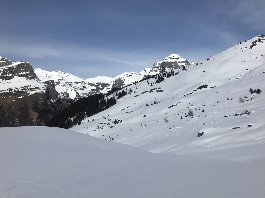
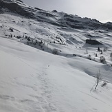
Grenier de Commune Photos
View all
Chablais Alps photos (21) |
Alps photos (1485) |
photos from mountains in France (302) |
all photos
 Upload new photo
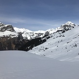
Commune
Commune
Grenier de Commune