– Lat/Long: 38.86° N 119.90° W
 Freel Peak
Weather Forecast, United StatesIssued: 10 pm Sun 02 Aug Local TimeUpdates in: hr min sUpdate imminent
Issued: 10 pm Sun 02 Aug Local Time
Updates in:
Update imminent hr min s

Issued: 10 pm Sun 02 Aug Local Time
Updates in:
Update imminent hr min s
Days 1–4 Weather SummaryMostly dry. Warm (max 24°C on Tue afternoon, min 16°C on Sun night). Winds increasing (calm on Mon night, fresh winds from the SW by Wed afternoon). | Days 5–7 Weather SummaryMostly dry. Warm (max 25°C on Fri afternoon, min 18°C on Wed night). Winds increasing (light winds from the SW on Thu morning, fresh winds from the SW by Sat afternoon). | ||||||||||||||||||
Monday 3 | Tuesday 4 | Wednesday 5 | Thursday 6 | Friday 7 | Saturday 8 | ||||||||||||||
night | AM | PM | night | AM | PM | night | AM | PM | night | AM | PM | night | AM | PM | night | AM | PM | night | |
clear | clear | clear | clear | clear | clear | clear | clear | clear | clear | clear | clear | clear | clear | clear | clear | clear | clear | clear | |
Cloud base (m) | 9200 | 5800 | |||||||||||||||||
km/h | |||||||||||||||||||
 |  |  |  |  |  |  | |||||||||||||
— | — | — | — | — | — | — | — | — | — | — | — | — | — | — | — | — | — | — | |
mm | — | — | — | — | — | — | — | — | — | — | — | — | — | — | — | — | — | — | — |
max °C | 19 | 20 | 23 | 20 | 21 | 24 | 20 | 22 | 24 | 20 | 22 | 24 | 20 | 22 | 25 | 21 | 23 | 24 | 20 |
min °C | 16 | 17 | 23 | 17 | 19 | 24 | 18 | 20 | 23 | 18 | 19 | 23 | 18 | 20 | 23 | 18 | 20 | 23 | 18 |
chill °C | 16 | 17 | 23 | 17 | 19 | 24 | 18 | 20 | 23 | 17 | 19 | 23 | 18 | 20 | 23 | 18 | 20 | 23 | 17 |
Freezing level m | 5400 | 5250 | 5550 | 5350 | 5350 | 5500 | 5450 | 5350 | 5450 | 5300 | 5350 | 5450 | 5450 | 5450 | 5500 | 5500 | 5450 | 5450 | 5400 |
— | 6:01 | — | — | 6:03 | — | — | 6:03 | — | — | 6:03 | — | — | 6:05 | — | — | 6:05 | — | — | |
— | — | — | 8:07 | — | — | 8:07 | — | — | 8:06 | — | — | 8:05 | — | — | 8:04 | — | — | 8:02 | |
Loading...
Freel Peak Weather (Days 0-3):
The weather forecast for Freel Peak is: Mostly dry. Warm (max 24°C on Tue afternoon, min 16°C on Sun night). Winds increasing (calm on Mon night, fresh winds from the SW by Wed afternoon).
Freel Peak Weather (Days 3-6):
Mostly dry. Warm (max 25°C on Fri afternoon, min 18°C on Wed night). Winds increasing (light winds from the SW on Thu morning, fresh winds from the SW by Sat afternoon).
This table gives the weather forecast for Freel Peak at the specific elevation of 2500 m. Our advanced weather models allow us to provide distinct weather forecasts for several elevations of Freel Peak. To see the weather forecasts for the other elevations, use the tab navigation above the table. For a wider overview of the weather, consult the Weather Map of California.
| Weather Station | Temp. | Weather | Wind | Gusts | Cloud / Visibility |
|---|---|---|---|---|---|
South Lake Tahoe Airport | |||||
Carson City Airport | |||||
Truckee Tahoe Airport | |||||
Reno Airport | |||||
Placerville Airport (California) | |||||
Emigrant Gap Airport | |||||
Reno Stead Airport | |||||
Westover Field / Amador County Airport - Jackson (California) |
* NOTE: not all weather observatories update at the same frequency which is the reason why some locations may show data from stations that are further away than known closer ones.
Freel Peak Photos
View all
Carson Range photos (32) |
Sierra Nevada photos (212) |
photos from mountains in United States (3056) |
all photos
 Upload new photo
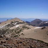

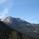
Jobs and Job's Sister from Freel Peak
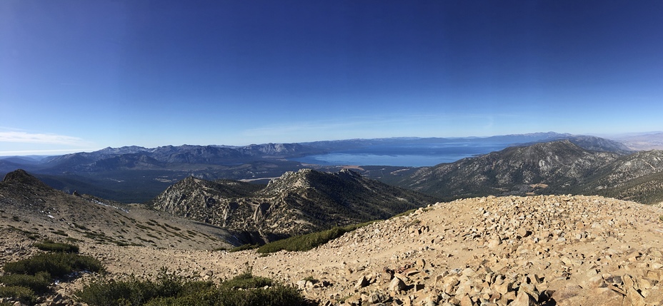
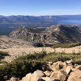
View from Freel Peak of Lake Tahoe
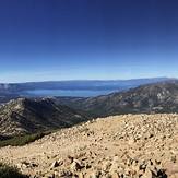
Freel, Job's, and Job's Sister
Freel Peak
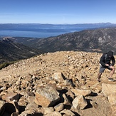
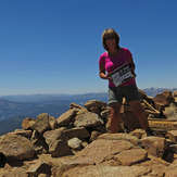
Solo on Freel Peak