– Lat/Long: 43.02° N 2.09° W
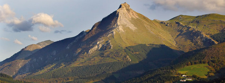
 Txindoki
Weather Forecast, SpainIssued: 7 pm Wed 15 Jul Local TimeUpdates in: hr min sUpdate imminent
Issued: 7 pm Wed 15 Jul Local Time
Updates in:
Update imminent hr min s

Issued: 7 pm Wed 15 Jul Local Time
Updates in:
Update imminent hr min s
Days 1–4 Weather SummaryMostly dry. Warm (max 22°C on Thu afternoon, min 13°C on Thu night). Wind will be generally light. | Days 5–7 Weather SummaryMostly dry. Warm (max 24°C on Mon afternoon, min 18°C on Sat night). Wind will be generally light. | ||||||||||||||||||
Thursday 16 | Friday 17 | Saturday 18 | Sunday 19 | Monday 20 | Tuesday 21 | ||||||||||||||
night | AM | PM | night | AM | PM | night | AM | PM | night | AM | PM | night | AM | PM | night | AM | PM | night | |
clear | clear | clear | rain shwrs | clear | clear | clear | clear | clear | some clouds | some clouds | some clouds | clear | clear | clear | clear | clear | clear | clear | |
km/h | |||||||||||||||||||
 |  |  |  |  |  |  | |||||||||||||
— | — | — | — | — | — | — | — | — | — | — | — | — | — | — | — | — | — | — | |
mm | — | — | — | 0.2 | — | — | — | — | — | — | — | — | — | — | — | — | — | — | — |
max °C | 21 | 19 | 22 | 18 | 15 | 15 | 16 | 18 | 20 | 21 | 20 | 22 | 23 | 22 | 24 | 23 | 21 | 22 | 23 |
min °C | 17 | 19 | 21 | 13 | 14 | 15 | 16 | 17 | 18 | 18 | 19 | 20 | 21 | 22 | 22 | 20 | 20 | 21 | 21 |
chill °C | 16 | 19 | 21 | 12 | 14 | 15 | 15 | 17 | 18 | 18 | 19 | 20 | 21 | 22 | 22 | 20 | 20 | 21 | 21 |
Freezing level m | 4450 | 4150 | 4250 | 4150 | 4000 | 4050 | 4300 | 4300 | 4450 | 4550 | 4550 | 4500 | 4600 | 4550 | 4650 | 4700 | 4700 | 4800 | 4850 |
Cloud base (m) | 450 | 4150 | 550 | 550 | 500 | 450 | |||||||||||||
— | 6:43 | — | — | 6:43 | — | — | 6:43 | — | — | 6:45 | — | — | 6:46 | — | — | 6:47 | — | — | |
— | — | — | 9:45 | — | — | 9:44 | — | — | 9:43 | — | — | 9:43 | — | — | 9:42 | — | — | 9:40 | |
Loading...
Txindoki Weather (Days 0-3):
The weather forecast for Txindoki is: Mostly dry. Warm (max 22°C on Thu afternoon, min 13°C on Thu night). Wind will be generally light.
Txindoki Weather (Days 3-6):
Mostly dry. Warm (max 24°C on Mon afternoon, min 18°C on Sat night). Wind will be generally light.
This table gives the weather forecast for Txindoki at the specific elevation of 1346 m. Our advanced weather models allow us to provide distinct weather forecasts for several elevations of Txindoki. To see the weather forecasts for the other elevations, use the tab navigation above the table. For a wider overview of the weather, consult the Weather Map of Spain.
| Weather Station | Temp. | Weather | Wind | Gusts | Cloud / Visibility |
|---|---|---|---|---|---|
Baiza Santa Marina | |||||
Aloña (Oñati) s310 | |||||
ERNIO s578 | |||||
San Sebastia / gueldo | |||||
San Sebastiá / uenterrabia Airport |
* NOTE: not all weather observatories update at the same frequency which is the reason why some locations may show data from stations that are further away than known closer ones.
Txindoki Photos
View all
Basque Mountains photos (22) |
Minor ranges of Europe photos (96) |
photos from mountains in Spain (451) |
all photos
 Upload new photo
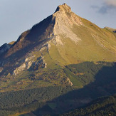
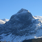
Txindoki
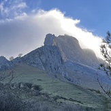
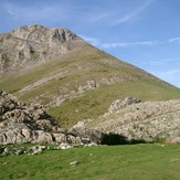
In the way to Txindoki
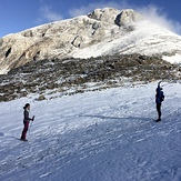
Txindoki with friends
Txindoki
Txindoki