– Lat/Long: 42.85° N 0.43° W
 Pic du Midi d'Ossau (Pic du Midi d-Ossau)
Weather Forecast, FranceIssued: 1 pm Mon 03 Aug Local TimeUpdates in: hr min sUpdate imminent
Issued: 1 pm Mon 03 Aug Local Time
Updates in:
Update imminent hr min s

Issued: 1 pm Mon 03 Aug Local Time
Updates in:
Update imminent hr min s
Days 1–4 Weather SummaryModerate rain (total 15mm), heaviest on Wed night. Very mild (max 11°C on Mon afternoon, min 8°C on Mon night). Mainly fresh winds. | Days 5–7 Weather SummaryLight rain (total 5mm), mostly falling on Sat night. Very mild (max 13°C on Sat afternoon, min 9°C on Thu afternoon). Winds increasing (light winds from the WSW on Fri afternoon, fresh winds from the WSW by Sat night). | ||||||||||||||||
Mon 3 | Tuesday 4 | Wednesday 5 | Thursday 6 | Friday 7 | Saturday 8 | ||||||||||||
PM | night | AM | PM | night | AM | PM | night | AM | PM | night | AM | PM | night | AM | PM | night | |
risk tstorm | rain shwrs | some clouds | rain shwrs | rain shwrs | clear | rain shwrs | risk tstorm | rain shwrs | risk tstorm | rain shwrs | rain shwrs | clear | clear | clear | some clouds | risk tstorm | |
Cloud base (m) | 3400 | 3800 | 3800 | 3550 | 2450 | 4550 | 4350 | ||||||||||
km/h | |||||||||||||||||
 |  |  |  |  |  | ||||||||||||
— | — | — | — | — | — | — | — | — | — | — | — | — | — | — | — | — | |
mm | 0.4 | 0.7 | — | 0.1 | 0.2 | — | 0.5 | 8 | 5 | 2 | 0.3 | 0.1 | — | — | — | — | 3 |
max °C | 11 | 9 | 9 | 11 | 10 | 10 | 11 | 11 | 9 | 10 | 10 | 9 | 11 | 11 | 12 | 13 | 12 |
min °C | 10 | 8 | 9 | 9 | 9 | 9 | 11 | 9 | 9 | 9 | 9 | 9 | 10 | 11 | 11 | 13 | 12 |
chill °C | 7 | 5 | 6 | 7 | 6 | 6 | 9 | 6 | 6 | 7 | 6 | 6 | 9 | 9 | 9 | 12 | 10 |
Freezing level m | 4350 | 4200 | 4300 | 4400 | 4500 | 4450 | 4500 | 4500 | 4400 | 4450 | 4500 | 4400 | 4450 | 4600 | 4600 | 4750 | 4650 |
— | — | 6:54 | — | — | 6:56 | — | — | 6:56 | — | — | 6:58 | — | — | 6:58 | — | — | |
— | 9:20 | — | — | 9:19 | — | — | 9:17 | — | — | 9:16 | — | — | 9:15 | — | — | 9:14 | |
Loading...
Pic du Midi d'Ossau Weather (Days 0-3):
The weather forecast for Pic du Midi d'Ossau is: Moderate rain (total 15mm), heaviest on Wed night. Very mild (max 11°C on Mon afternoon, min 8°C on Mon night). Mainly fresh winds.
Pic du Midi d'Ossau Weather (Days 3-6):
Light rain (total 5mm), mostly falling on Sat night. Very mild (max 13°C on Sat afternoon, min 9°C on Thu afternoon). Winds increasing (light winds from the WSW on Fri afternoon, fresh winds from the WSW by Sat night).
This table gives the weather forecast for Pic du Midi d'Ossau at the specific elevation of 2885 m. Our advanced weather models allow us to provide distinct weather forecasts for several elevations of Pic du Midi d'Ossau. To see the weather forecasts for the other elevations, use the tab navigation above the table. For a wider overview of the weather, consult the Weather Map of France.
| Weather Station | Temp. | Weather | Wind | Gusts | Cloud / Visibility |
|---|---|---|---|---|---|
lightning 15km SE of Sallent de Gallego | |||||
lightning 17km S of Cauterets | |||||
lightning 22km NE of Sabinanigo | |||||
lightning 36km SSW of Arette | |||||
lightning 26km NW of Ainsa | |||||
lightning 14km SE of Luz-Saint-Sauveur | |||||
lightning 13km W of Saint-Lary-Soulan | |||||
lightning 8km S of Campan | |||||
thunderstorm affecting Bagneres-de-Bigorre |
* NOTE: not all weather observatories update at the same frequency which is the reason why some locations may show data from stations that are further away than known closer ones.
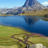
Pic du Midi d'Ossau Photos
View all
photos (101) |
Pyrenees photos (143) |
photos from mountains in France (302) |
all photos
 Upload new photo
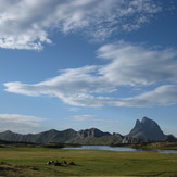
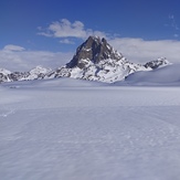
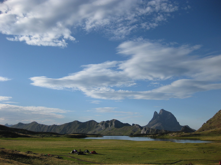
solos frente al midi
Lagos ayous
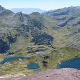
pic midi d ossau
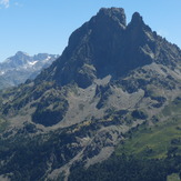
Midi
Pic du Midi d'Ossau