
– Lat/Long: 42.95° N 5.10° W
 Penas Pintas
Weather Forecast, SpainIssued: 7 am Mon 03 Aug Local TimeUpdates in: hr min sUpdate imminent
Issued: 7 am Mon 03 Aug Local Time
Updates in:
Update imminent hr min s

Issued: 7 am Mon 03 Aug Local Time
Updates in:
Update imminent hr min s
Days 1–3 Weather SummaryLight rain (total 2mm), mostly falling on Mon night. Very mild (max 17°C on Mon afternoon, min 10°C on Wed night). Wind will be generally light. | Days 4–6 Weather SummaryMostly dry. Very mild (max 19°C on Fri afternoon, min 10°C on Thu morning). Wind will be generally light. | |||||||||||||||||
Monday 3 | Tuesday 4 | Wednesday 5 | Thursday 6 | Friday 7 | Saturday 8 | |||||||||||||
AM | PM | night | AM | PM | night | AM | PM | night | AM | PM | night | AM | PM | night | AM | PM | night | |
some clouds | rain shwrs | rain shwrs | clear | clear | clear | some clouds | clear | rain shwrs | light rain | rain shwrs | clear | clear | clear | clear | clear | clear | risk tstorm | |
Cloud base (m) | 5200 | 3050 | 1600 | 950 | 950 | 1000 | 950 | 4150 | 9000 | 4250 | ||||||||
km/h | ||||||||||||||||||
 |  |  |  |  |  | |||||||||||||
— | — | — | — | — | — | — | — | — | — | — | — | — | — | — | — | — | — | |
mm | — | 0.6 | 1.1 | — | — | — | — | — | 0.3 | 0.3 | 0.2 | — | — | — | — | — | — | 0.2 |
max °C | 15 | 17 | 15 | 14 | 17 | 14 | 13 | 16 | 12 | 10 | 14 | 13 | 15 | 19 | 17 | 17 | 19 | 16 |
min °C | 14 | 17 | 12 | 12 | 16 | 12 | 12 | 16 | 10 | 10 | 12 | 11 | 13 | 18 | 14 | 14 | 19 | 15 |
chill °C | 13 | 16 | 12 | 11 | 16 | 12 | 12 | 16 | 9 | 9 | 12 | 10 | 12 | 18 | 14 | 14 | 19 | 15 |
Freezing level m | 4050 | 4150 | 4100 | 4300 | 4400 | 4500 | 4350 | 4250 | 4250 | 4250 | 4200 | 4300 | 4350 | 4400 | 4350 | 4250 | 4400 | 4300 |
7:11 | — | — | 7:13 | — | — | 7:13 | — | — | 7:15 | — | — | 7:16 | — | — | 7:18 | — | — | |
— | — | 9:38 | — | — | 9:37 | — | — | 9:37 | — | — | 9:36 | — | — | 9:34 | — | — | 9:32 | |
Loading...
Penas Pintas Weather (Days 0-3):
The weather forecast for Penas Pintas is: Light rain (total 2mm), mostly falling on Mon night. Very mild (max 17°C on Mon afternoon, min 10°C on Wed night). Wind will be generally light.
Penas Pintas Weather (Days 3-6):
Mostly dry. Very mild (max 19°C on Fri afternoon, min 10°C on Thu morning). Wind will be generally light.
This table gives the weather forecast for Penas Pintas at the specific elevation of 1983 m. Our advanced weather models allow us to provide distinct weather forecasts for several elevations of Penas Pintas. To see the weather forecasts for the other elevations, use the tab navigation above the table. For a wider overview of the weather, consult the Weather Map of Spain.
| Weather Station | Temp. | Weather | Wind | Gusts | Cloud / Visibility |
|---|---|---|---|---|---|
Vuelo Libre León 1 | |||||
La Llambria 1753 m | |||||
Culla L´Arcu | |||||
Leo / irgen Del Camino | |||||
Callejo de Ordás | |||||
Villaceid (León) |
* NOTE: not all weather observatories update at the same frequency which is the reason why some locations may show data from stations that are further away than known closer ones.
Penas Pintas Photos
View all
Picos de Europa photos (31) |
Cantabrian Mountains (Cordillera Cantabrica) photos (41) |
photos from mountains in Spain (451) |
all photos
 Upload new photo
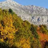
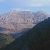
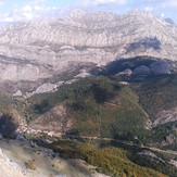
Peñas Pintas desde el Yordas