– Lat/Long: 46.04° N 7.67° E
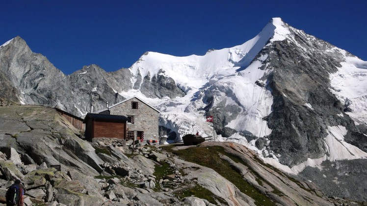
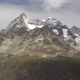
 Ober-Gabelhorn
Weather Forecast, SwitzerlandIssued: 1 pm Mon 03 Aug Local TimeUpdates in: hr min sUpdate imminent
Issued: 1 pm Mon 03 Aug Local Time
Updates in:
Update imminent hr min s

Issued: 1 pm Mon 03 Aug Local Time
Updates in:
Update imminent hr min s
Days 1–4 Weather SummaryHeavy rain (total 31mm), heaviest during Wed night. Warm (max 22°C on Mon afternoon, min 17°C on Mon night). Wind will be generally light. | Days 5–7 Weather SummaryHeavy rain (total 26mm), heaviest during Thu night. Warm (max 22°C on Thu afternoon, min 15°C on Thu night). Wind will be generally light. | ||||||||||||||||
Mon 3 | Tuesday 4 | Wednesday 5 | Thursday 6 | Friday 7 | Saturday 8 | ||||||||||||
PM | night | AM | PM | night | AM | PM | night | AM | PM | night | AM | PM | night | AM | PM | night | |
risk tstorm | risk tstorm | rain shwrs | risk tstorm | rain shwrs | clear | rain shwrs | rain shwrs | clear | rain shwrs | rain shwrs | rain shwrs | risk tstorm | rain shwrs | clear | rain shwrs | rain shwrs | |
Cloud base (m) | 4000 | 4850 | 4650 | 4350 | 3900 | 2850 | 3700 | ||||||||||
km/h | |||||||||||||||||
 |  |  |  |  |  | ||||||||||||
— | — | — | — | — | — | — | — | — | — | — | — | — | — | — | — | — | |
mm | 2 | 3 | 0.1 | 3 | 4 | — | 4 | 14 | — | 5 | 13 | 0.3 | 3 | 1.1 | — | 3 | 0.8 |
max °C | 22 | 19 | 21 | 22 | 19 | 21 | 22 | 18 | 21 | 22 | 16 | 19 | 21 | 18 | 20 | 21 | 20 |
min °C | 21 | 17 | 18 | 21 | 18 | 18 | 21 | 17 | 18 | 19 | 15 | 16 | 20 | 16 | 16 | 21 | 17 |
chill °C | 21 | 17 | 18 | 21 | 18 | 18 | 21 | 17 | 18 | 19 | 15 | 16 | 20 | 16 | 16 | 21 | 17 |
Freezing level m | 4500 | 4400 | 4400 | 4500 | 4450 | 4500 | 4550 | 4400 | 4400 | 4350 | 4150 | 4200 | 4350 | 4200 | 4350 | 4450 | 4350 |
— | — | 6:13 | — | — | 6:15 | — | — | 6:16 | — | — | 6:18 | — | — | 6:18 | — | — | |
— | 8:57 | — | — | 8:54 | — | — | 8:53 | — | — | 8:52 | — | — | 8:51 | — | — | 8:50 | |
Loading...
Ober-Gabelhorn Weather (Days 0-3):
The weather forecast for Ober-Gabelhorn is: Heavy rain (total 31mm), heaviest during Wed night. Warm (max 22°C on Mon afternoon, min 17°C on Mon night). Wind will be generally light.
Ober-Gabelhorn Weather (Days 3-6):
Heavy rain (total 26mm), heaviest during Thu night. Warm (max 22°C on Thu afternoon, min 15°C on Thu night). Wind will be generally light.
This table gives the weather forecast for Ober-Gabelhorn at the specific elevation of 1500 m. Our advanced weather models allow us to provide distinct weather forecasts for several elevations of Ober-Gabelhorn. To see the weather forecasts for the other elevations, use the tab navigation above the table. For a wider overview of the weather, consult the Weather Map of Switzerland.
| Weather Station | Temp. | Weather | Wind | Gusts | Cloud / Visibility |
|---|---|---|---|---|---|
ZFC: Riffelberg | |||||
ZFC: Schwarzsee | |||||
lightning 12km WSW of Zermatt | |||||
lightning 11km N of Valtournenche | |||||
ZFC: Landing Zermatt | |||||
ZFC: Gornergrat N. | |||||
ZFC: Gornergr. North | |||||
Mottec |
* NOTE: not all weather observatories update at the same frequency which is the reason why some locations may show data from stations that are further away than known closer ones.
Ober-Gabelhorn Photos
View all
Pennine Alps photos (202) |
Alps photos (1485) |
photos from mountains in Switzerland (649) |
all photos
 Upload new photo
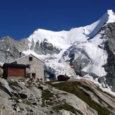
Ober-Gabelhorn
Ober Gabelhorn