– Lat/Long: 46.20° N 122.18° W
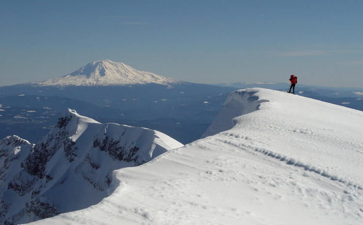
 Mount Saint Helens
Weather Forecast, United StatesIssued: 4 am Mon 03 Aug Local TimeUpdates in: hr min sUpdate imminent
Issued: 4 am Mon 03 Aug Local Time
Updates in:
Update imminent hr min s

Issued: 4 am Mon 03 Aug Local Time
Updates in:
Update imminent hr min s
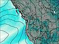
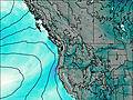
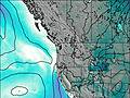
Days 1–3 Weather SummaryMostly dry. Very mild (max 19°C on Wed afternoon, min 9°C on Mon morning). Wind will be generally light. | Days 4–6 Weather SummaryMostly dry. Very mild (max 18°C on Thu afternoon, min 11°C on Fri morning). Wind will be generally light. | |||||||||||||||||
Monday 3 | Tuesday 4 | Wednesday 5 | Thursday 6 | Friday 7 | Saturday 8 | |||||||||||||
AM | PM | night | AM | PM | night | AM | PM | night | AM | PM | night | AM | PM | night | AM | PM | night | |
clear | clear | clear | clear | clear | clear | clear | clear | clear | clear | clear | clear | clear | clear | clear | clear | some clouds | clear | |
Cloud base (m) | 9550 | 8850 | 9650 | |||||||||||||||
km/h | ||||||||||||||||||
 |  |  |  |  |  | |||||||||||||
— | — | — | — | — | — | — | — | — | — | — | — | — | — | — | — | — | — | |
mm | — | — | — | — | — | — | — | — | — | — | — | — | — | — | — | — | — | — |
max °C | 10 | 14 | 14 | 15 | 18 | 17 | 17 | 19 | 18 | 17 | 18 | 16 | 12 | 13 | 12 | 11 | 13 | 11 |
min °C | 9 | 13 | 14 | 14 | 17 | 17 | 17 | 19 | 18 | 17 | 18 | 13 | 11 | 12 | 12 | 11 | 13 | 11 |
chill °C | 7 | 13 | 14 | 14 | 17 | 17 | 17 | 19 | 18 | 17 | 18 | 11 | 8 | 10 | 10 | 9 | 11 | 9 |
Freezing level m | 3950 | 4150 | 4300 | 4350 | 4600 | 4700 | 4800 | 4850 | 4950 | 4850 | 4800 | 4700 | 4300 | 4400 | 4550 | 4500 | 4450 | 4400 |
5:52 | — | — | 5:52 | — | — | 5:54 | — | — | 5:56 | — | — | 5:56 | — | — | 5:58 | — | — | |
— | — | 8:36 | — | — | 8:35 | — | — | 8:32 | — | — | 8:31 | — | — | 8:30 | — | — | 8:29 | |
Loading...
Mount Saint Helens Weather (Days 0-3):
The weather forecast for Mount Saint Helens is: Mostly dry. Very mild (max 19°C on Wed afternoon, min 9°C on Mon morning). Wind will be generally light.
Mount Saint Helens Weather (Days 3-6):
Mostly dry. Very mild (max 18°C on Thu afternoon, min 11°C on Fri morning). Wind will be generally light.
This table gives the weather forecast for Mount Saint Helens at the specific elevation of 2000 m. Our advanced weather models allow us to provide distinct weather forecasts for several elevations of Mount Saint Helens. To see the weather forecasts for the other elevations, use the tab navigation above the table. For a wider overview of the weather, consult the Weather Map of Washington.
| Weather Station | Temp. | Weather | Wind | Gusts | Cloud / Visibility |
|---|---|---|---|---|---|
BUOY-KLMW1 | |||||
BUOY-LOPW1 | |||||
Vancouver Airport | |||||
Portland Airport | |||||
Ken Jernstedt Airfield - Hood River (Oregon) | |||||
Pierce County Airport - Thun Field - Puyallup (Washington) | |||||
Fort Lewi / ray Army Airfield Airport |
* NOTE: not all weather observatories update at the same frequency which is the reason why some locations may show data from stations that are further away than known closer ones.
Mount Saint Helens Photos
View all
Cascade Range photos (451) |
Pacific Coast Ranges photos (1060) |
photos from mountains in United States (3056) |
all photos
 Upload new photo
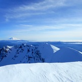
 See 40 more Mount Saint Helens photos
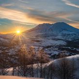
Mount St Helens
South Rim view...
Mount Saint Helens
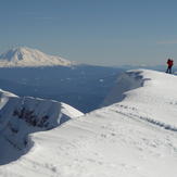
View of Rainier from South Rim
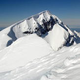
True Summit...
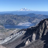
Inside the Crater...
Mt. St. Helens