– Lat/Long: 35.07° N 133.24° E
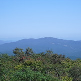
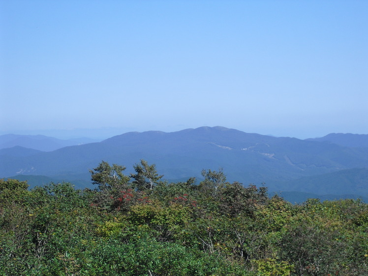
 Mount Dōgo (Mount Dogo)
Weather Forecast, JapanIssued: 2 am Tue 04 Aug Local TimeUpdates in: hr min sUpdate imminent
Issued: 2 am Tue 04 Aug Local Time
Updates in:
Update imminent hr min s

Issued: 2 am Tue 04 Aug Local Time
Updates in:
Update imminent hr min s
Days 1–3 Weather SummaryModerate rain (total 15mm), heaviest on Tue morning. Warm (max 23°C on Wed afternoon, min 20°C on Tue night). Winds increasing (light winds from the NNE on Tue morning, near gales from the ESE by Thu night). | Days 4–6 Weather SummaryMostly dry. Warm (max 23°C on Fri afternoon, min 19°C on Sat morning). Winds increasing (fresh winds from the ESE on Fri afternoon, gales from the ESE by Sun night). | |||||||||||||||||
Tuesday 4 | Wednesday 5 | Thursday 6 | Friday 7 | Saturday 8 | Sunday 9 | |||||||||||||
AM | PM | night | AM | PM | night | AM | PM | night | AM | PM | night | AM | PM | night | AM | PM | night | |
risk tstorm | risk tstorm | rain shwrs | rain shwrs | rain shwrs | clear | clear | clear | clear | clear | clear | clear | some clouds | risk tstorm | rain shwrs | cloudy | light rain | cloudy | |
Cloud base (m) | 750 | 800 | 800 | 2150 | 600 | 2100 | 550 | 1450 | 700 | 800 | 1450 | 600 | ||||||
km/h | ||||||||||||||||||
 |  |  |  |  |  | |||||||||||||
— | — | — | — | — | — | — | — | — | — | — | — | — | — | — | — | — | — | |
mm | 6 | 7 | 1.1 | 0.7 | 0.2 | — | — | — | — | — | — | — | — | 0.4 | 0.2 | — | 0.2 | — |
max °C | 22 | 22 | 21 | 22 | 23 | 21 | 22 | 23 | 21 | 22 | 23 | 21 | 20 | 21 | 20 | 19 | 20 | 19 |
min °C | 21 | 22 | 20 | 21 | 23 | 21 | 21 | 23 | 20 | 20 | 22 | 20 | 19 | 21 | 19 | 19 | 19 | 19 |
chill °C | 21 | 22 | 20 | 21 | 23 | 21 | 21 | 23 | 19 | 19 | 22 | 19 | 18 | 21 | 18 | 18 | 18 | 18 |
Freezing level m | 5550 | 5650 | 5550 | 5450 | 5600 | 5600 | 5550 | 5550 | 5550 | 5400 | 5450 | 5450 | 5300 | 5300 | 5350 | 5250 | 5350 | 5400 |
5:18 | — | — | 5:18 | — | — | 5:18 | — | — | 5:20 | — | — | 5:20 | — | — | 5:20 | — | — | |
— | 7:07 | — | — | 7:06 | — | — | 7:05 | — | — | 7:04 | — | — | 7:02 | — | — | 7:01 | — | |
Loading...
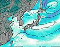
Mount Dōgo Weather (Days 0-3):
The weather forecast for Mount Dōgo is: Moderate rain (total 15mm), heaviest on Tue morning. Warm (max 23°C on Wed afternoon, min 20°C on Tue night). Winds increasing (light winds from the NNE on Tue morning, near gales from the ESE by Thu night).
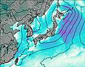
Mount Dōgo Weather (Days 3-6):
Mostly dry. Warm (max 23°C on Fri afternoon, min 19°C on Sat morning). Winds increasing (fresh winds from the ESE on Fri afternoon, gales from the ESE by Sun night).
This table gives the weather forecast for Mount Dōgo at the specific elevation of 1268 m. Our advanced weather models allow us to provide distinct weather forecasts for several elevations of Mount Dōgo. To see the weather forecasts for the other elevations, use the tab navigation above the table. For a wider overview of the weather, consult the Weather Map of Japan.
| Weather Station | Temp. | Weather | Wind | Gusts | Cloud / Visibility |
|---|---|---|---|---|---|
Miho Airport | |||||
Izumo Airport | |||||
lightning 7km NNE of Kanonji | |||||
* NOTE: not all weather observatories update at the same frequency which is the reason why some locations may show data from stations that are further away than known closer ones.