– Lat/Long: 46.62° N 7.79° E
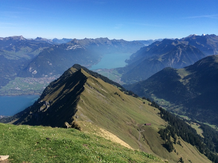
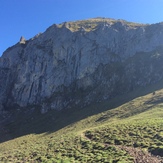
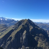
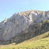
 Morgenberghorn
Weather Forecast, SwitzerlandIssued: 7 pm Thu 16 Jul Local TimeUpdates in: hr min sUpdate imminent
Issued: 7 pm Thu 16 Jul Local Time
Updates in:
Update imminent hr min s

Issued: 7 pm Thu 16 Jul Local Time
Updates in:
Update imminent hr min s
Days 1–4 Weather SummaryHeavy rain (total 40mm), heaviest during Thu night. Very mild (max 14°C on Fri afternoon, min 8°C on Sun morning). Wind will be generally light. | Days 5–7 Weather SummaryLight rain (total 3mm), mostly falling on Mon night. Very mild (max 11°C on Mon afternoon, min 5°C on Mon night). Wind will be generally light. | ||||||||||||||||||
Friday 17 | Saturday 18 | Sunday 19 | Monday 20 | Tuesday 21 | Wednesday 22 | ||||||||||||||
night | AM | PM | night | AM | PM | night | AM | PM | night | AM | PM | night | AM | PM | night | AM | PM | night | |
rain shwrs | rain shwrs | rain shwrs | risk tstorm | risk tstorm | risk tstorm | rain shwrs | rain shwrs | risk tstorm | rain shwrs | clear | rain shwrs | rain shwrs | clear | some clouds | clear | clear | clear | rain shwrs | |
km/h | |||||||||||||||||||
 |  |  |  |  |  |  | |||||||||||||
— | — | — | — | — | — | — | — | — | — | — | — | — | — | — | — | — | — | — | |
mm | 13 | 0.4 | 0.6 | 9 | 2 | 3 | 3 | 3 | 6 | 0.2 | — | 1.1 | 1.4 | — | — | — | — | — | 0.6 |
max °C | 12 | 13 | 14 | 14 | 10 | 11 | 9 | 9 | 9 | 9 | 10 | 11 | 9 | 6 | 8 | 7 | 9 | 11 | 10 |
min °C | 11 | 10 | 14 | 10 | 10 | 10 | 9 | 8 | 8 | 8 | 9 | 10 | 5 | 5 | 7 | 7 | 8 | 10 | 8 |
chill °C | 8 | 7 | 13 | 8 | 8 | 9 | 7 | 6 | 6 | 6 | 7 | 8 | 3 | 4 | 5 | 6 | 8 | 9 | 6 |
Freezing level m | 4000 | 4100 | 4100 | 3900 | 3600 | 3650 | 3600 | 3450 | 3500 | 3650 | 3550 | 3600 | 3400 | 3050 | 3100 | 3600 | 3600 | 3600 | 3550 |
Cloud base (m) | 2550 | 2200 | 7800 | 3200 | 2950 | 2850 | 3300 | 3250 | 8600 | 3600 | |||||||||
— | 5:50 | — | — | 5:52 | — | — | 5:52 | — | — | 5:54 | — | — | 5:54 | — | — | 5:56 | — | — | |
— | — | — | 9:16 | — | — | 9:15 | — | — | 9:15 | — | — | 9:14 | — | — | 9:13 | — | — | 9:12 | |
Loading...
Morgenberghorn Weather (Days 0-3):
The weather forecast for Morgenberghorn is: Heavy rain (total 40mm), heaviest during Thu night. Very mild (max 14°C on Fri afternoon, min 8°C on Sun morning). Wind will be generally light.
Morgenberghorn Weather (Days 3-6):
Light rain (total 3mm), mostly falling on Mon night. Very mild (max 11°C on Mon afternoon, min 5°C on Mon night). Wind will be generally light.
This table gives the weather forecast for Morgenberghorn at the specific elevation of 2249 m. Our advanced weather models allow us to provide distinct weather forecasts for several elevations of Morgenberghorn. To see the weather forecasts for the other elevations, use the tab navigation above the table. For a wider overview of the weather, consult the Weather Map of Switzerland.
| Weather Station | Temp. | Weather | Wind | Gusts | Cloud / Visibility |
|---|---|---|---|---|---|
Lehn holfuy | |||||
Höhematte holfuy | |||||
Amisbühl holfuy | |||||
Schiltgrat | |||||
Grimer | |||||
lightning 10km S of Lauterbrunnen | |||||
Allmenalp-PGK | |||||
lightning 14km E of Kandersteg |
* NOTE: not all weather observatories update at the same frequency which is the reason why some locations may show data from stations that are further away than known closer ones.
Morgenberghorn Photos
View all
Bernese Alps photos (163) |
Alps photos (1484) |
photos from mountains in Switzerland (649) |
all photos
 Upload new photo
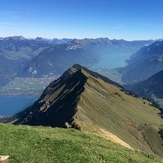


 See 8 more Morgenberghorn photos
Sumit
Mogenberghorn