– Lat/Long: 44.67° N 7.12° E
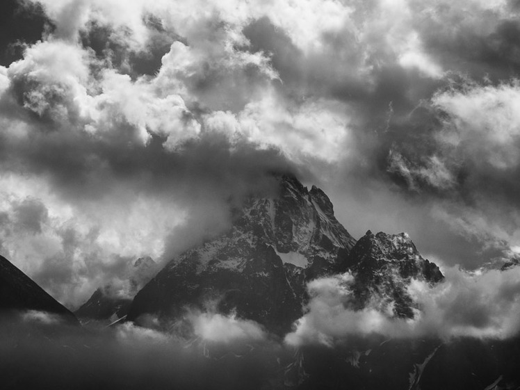
 Monviso
Weather Forecast, ItalyIssued: 7 pm Mon 03 Aug Local TimeUpdates in: hr min sUpdate imminent
Issued: 7 pm Mon 03 Aug Local Time
Updates in:
Update imminent hr min s

Issued: 7 pm Mon 03 Aug Local Time
Updates in:
Update imminent hr min s
Days 1–4 Weather SummaryModerate rain (total 12mm), heaviest on Tue afternoon. Very mild (max 11°C on Thu afternoon, min 9°C on Mon night). Wind will be generally light. | Days 5–7 Weather SummaryLight rain (total 9mm), mostly falling on Sat night. Very mild (max 11°C on Thu night, min 7°C on Sat morning). Wind will be generally light. | |||||||||||||||
Tuesday 4 | Wednesday 5 | Thursday 6 | Friday 7 | Saturday 8 | ||||||||||||
night | AM | PM | night | AM | PM | night | AM | PM | night | AM | PM | night | AM | PM | night | |
risk tstorm | rain shwrs | risk tstorm | risk tstorm | rain shwrs | rain shwrs | rain shwrs | clear | risk tstorm | risk tstorm | clear | risk tstorm | risk tstorm | clear | risk tstorm | risk tstorm | |
Cloud base (m) | 5000 | 3650 | 3550 | 4300 | 4550 | 4250 | 2400 | |||||||||
km/h | ||||||||||||||||
 |  |  |  |  |  | |||||||||||
— | — | — | — | — | — | — | — | — | — | — | — | — | — | — | — | |
mm | 1.7 | 0.1 | 3 | 4 | 0.1 | 1.6 | 0.1 | — | 0.4 | 0.9 | — | 1.4 | 0.9 | — | 2 | 3 |
max °C | 10 | 10 | 10 | 10 | 9 | 10 | 10 | 10 | 11 | 11 | 9 | 10 | 10 | 8 | 10 | 10 |
min °C | 9 | 10 | 10 | 9 | 9 | 10 | 10 | 10 | 11 | 9 | 8 | 9 | 8 | 7 | 9 | 8 |
chill °C | 7 | 8 | 8 | 8 | 9 | 10 | 9 | 10 | 10 | 8 | 8 | 8 | 7 | 7 | 7 | 8 |
Freezing level m | 4500 | 4400 | 4450 | 4450 | 4450 | 4600 | 4600 | 4450 | 4600 | 4400 | 4200 | 4400 | 4300 | 4250 | 4500 | 4350 |
— | 6:20 | — | — | 6:20 | — | — | 6:22 | — | — | 6:22 | — | — | 6:24 | — | — | |
— | — | — | 8:53 | — | — | 8:52 | — | — | 8:51 | — | — | 8:50 | — | — | 8:47 | |
Loading...
Monviso Weather (Days 0-3):
The weather forecast for Monviso is: Moderate rain (total 12mm), heaviest on Tue afternoon. Very mild (max 11°C on Thu afternoon, min 9°C on Mon night). Wind will be generally light.
Monviso Weather (Days 3-6):
Light rain (total 9mm), mostly falling on Sat night. Very mild (max 11°C on Thu night, min 7°C on Sat morning). Wind will be generally light.
This table gives the weather forecast for Monviso at the specific elevation of 3000 m. Our advanced weather models allow us to provide distinct weather forecasts for several elevations of Monviso. To see the weather forecasts for the other elevations, use the tab navigation above the table. For a wider overview of the weather, consult the Weather Map of Italy.
| Weather Station | Temp. | Weather | Wind | Gusts | Cloud / Visibility |
|---|---|---|---|---|---|
lightning 11km SW of Paesana | |||||
lightning 10km SW of Torre Pellice | |||||
lightning 9km SW of Sanfront | |||||
lightning 7km W of Bagnolo Piemonte | |||||
lightning 17km WNW of Roccabruna | |||||
thunderstorm affecting Barge | |||||
thunderstorm affecting Revello | |||||
lightning 22km NE of Jausiers | |||||
lightning 5km W of Manta | |||||
thunderstorm affecting Cavour |
* NOTE: not all weather observatories update at the same frequency which is the reason why some locations may show data from stations that are further away than known closer ones.
Monviso Photos
View all
Cottian Alps photos (11) |
Alps photos (1485) |
photos from mountains in Italy (430) |
all photos
 Upload new photo

September storm hits Monviso
Monviso