– Lat/Long: 44.05° N 6.24° E
 Le Cousson
Weather Forecast, FranceIssued: 1 pm Mon 03 Aug Local TimeUpdates in: hr min sUpdate imminent
Issued: 1 pm Mon 03 Aug Local Time
Updates in:
Update imminent hr min s

Issued: 1 pm Mon 03 Aug Local Time
Updates in:
Update imminent hr min s
Days 1–4 Weather SummarySome drizzle, heaviest during Tue night. Warm (max 34°C on Wed afternoon, min 22°C on Tue night). Wind will be generally light. | Days 5–7 Weather SummaryMostly dry. Warm (max 33°C on Thu afternoon, min 21°C on Thu night). Wind will be generally light. | ||||||||||||||||
Mon 3 | Tuesday 4 | Wednesday 5 | Thursday 6 | Friday 7 | Saturday 8 | ||||||||||||
PM | night | AM | PM | night | AM | PM | night | AM | PM | night | AM | PM | night | AM | PM | night | |
rain shwrs | some clouds | some clouds | clear | risk tstorm | clear | clear | clear | clear | some clouds | rain shwrs | clear | clear | clear | clear | clear | clear | |
Cloud base (m) | 6200 | 5700 | 5000 | 7100 | 6700 | 3550 | |||||||||||
km/h | |||||||||||||||||
 |  |  |  |  |  | ||||||||||||
— | — | — | — | — | — | — | — | — | — | — | — | — | — | — | — | — | |
mm | 0.1 | — | — | — | 1.2 | — | — | — | — | — | 0.2 | — | — | — | — | — | — |
max °C | 33 | 30 | 30 | 32 | 28 | 29 | 34 | 31 | 30 | 33 | 30 | 27 | 33 | 29 | 28 | 33 | 30 |
min °C | 32 | 23 | 25 | 31 | 22 | 23 | 32 | 24 | 26 | 32 | 21 | 22 | 31 | 22 | 23 | 32 | 23 |
chill °C | 32 | 23 | 25 | 31 | 22 | 23 | 32 | 24 | 26 | 32 | 21 | 22 | 31 | 22 | 23 | 32 | 23 |
Freezing level m | 4600 | 4500 | 4400 | 4400 | 4500 | 4500 | 4700 | 4600 | 4450 | 4500 | 4600 | 4500 | 4550 | 4650 | 4600 | 4550 | 4650 |
— | — | 6:24 | — | — | 6:26 | — | — | 6:26 | — | — | 6:28 | — | — | 6:30 | — | — | |
— | 8:57 | — | — | 8:55 | — | — | 8:53 | — | — | 8:52 | — | — | 8:52 | — | — | 8:50 | |
Loading...
Le Cousson Weather (Days 0-3):
The weather forecast for Le Cousson is: Some drizzle, heaviest during Tue night. Warm (max 34°C on Wed afternoon, min 22°C on Tue night). Wind will be generally light.
Le Cousson Weather (Days 3-6):
Mostly dry. Warm (max 33°C on Thu afternoon, min 21°C on Thu night). Wind will be generally light.
This table gives the weather forecast for Le Cousson at the specific elevation of 550 m. Our advanced weather models allow us to provide distinct weather forecasts for several elevations of Le Cousson. To see the weather forecasts for the other elevations, use the tab navigation above the table. For a wider overview of the weather, consult the Weather Map of France.
| Weather Station | Temp. | Weather | Wind | Gusts | Cloud / Visibility |
|---|---|---|---|---|---|
ST -Auban -Sur -Durance | |||||
Embrun | |||||
décollage du puet | |||||
lightning 10km NNE of Chorges | |||||
lightning 13km NNW of Embrun | |||||
Devoluy Altisurface | |||||
lightning 20km NE of Jausiers | |||||
lightning 9km WNW of Sault | |||||
LE Luc |
* NOTE: not all weather observatories update at the same frequency which is the reason why some locations may show data from stations that are further away than known closer ones.
Le Cousson Photos
View all
Maritime Alps photos (29) |
Alps photos (1485) |
photos from mountains in France (302) |
all photos
 Upload new photo
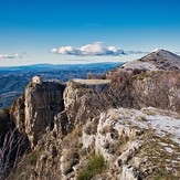
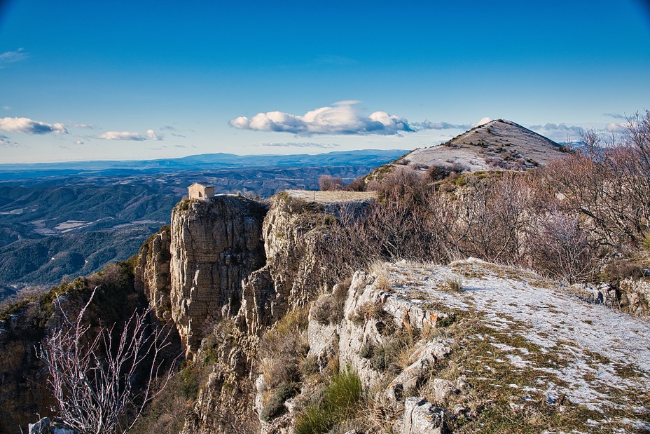
La chapelle
Le cousson
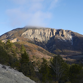
le sommet du cousson