– Lat/Long: 21.45° N 157.90° W
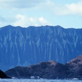
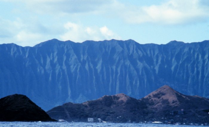
 Koʻolau Range (Ko_olau Range)
Weather Forecast, United StatesIssued: 7 pm Mon 27 Jul Local TimeUpdates in: hr min sUpdate imminent
Issued: 7 pm Mon 27 Jul Local Time
Updates in:
Update imminent hr min s

Issued: 7 pm Mon 27 Jul Local Time
Updates in:
Update imminent hr min s
Days 1–4 Weather SummaryLight rain (total 9mm), mostly falling on Wed afternoon. Warm (max 24°C on Tue morning, min 22°C on Mon night). Winds decreasing (fresh winds from the NE on Mon night, calm by Wed afternoon). | Days 5–7 Weather SummaryLight rain (total 3mm), mostly falling on Sat night. Warm (max 23°C on Fri morning, min 21°C on Fri night). Winds increasing (moderate winds from the E on Thu night, strong winds from the ENE by Fri night). | ||||||||||||||||||
Tuesday 28 | Wednesday 29 | Thursday 30 | Friday 31 | Saturday 1 | Sunday 2 | ||||||||||||||
night | AM | PM | night | AM | PM | night | AM | PM | night | AM | PM | night | AM | PM | night | AM | PM | night | |
risk tstorm | risk tstorm | risk tstorm | rain shwrs | rain shwrs | risk tstorm | risk tstorm | clear | rain shwrs | risk tstorm | rain shwrs | rain shwrs | risk tstorm | clear | rain shwrs | rain shwrs | rain shwrs | rain shwrs | rain shwrs | |
Cloud base (m) | 250 | 500 | 350 | 400 | 850 | 1850 | 750 | 500 | 700 | 450 | 450 | 650 | 700 | 500 | |||||
km/h | |||||||||||||||||||
 |  |  |  |  |  |  | |||||||||||||
— | — | — | — | — | — | — | — | — | — | — | — | — | — | — | — | — | — | — | |
mm | 2 | 1.3 | 0.3 | 0.6 | 0.4 | 1.5 | 2 | — | 0.1 | 0.4 | 0.1 | 0.1 | 0.3 | — | 0.2 | 0.8 | 0.4 | 0.2 | 0.4 |
max °C | 22 | 24 | 24 | 23 | 24 | 24 | 23 | 24 | 24 | 22 | 23 | 23 | 22 | 22 | 22 | 21 | 22 | 22 | 21 |
min °C | 22 | 23 | 24 | 22 | 22 | 24 | 22 | 23 | 23 | 22 | 22 | 23 | 21 | 22 | 22 | 21 | 21 | 22 | 21 |
chill °C | 22 | 23 | 24 | 22 | 22 | 24 | 22 | 23 | 23 | 22 | 22 | 23 | 21 | 22 | 22 | 21 | 21 | 22 | 21 |
Freezing level m | 5150 | 5150 | 5100 | 5100 | 4900 | 4800 | 4750 | 4750 | 4800 | 4750 | 4750 | 4750 | 4800 | 4850 | 4850 | 4750 | 4700 | 4750 | 4700 |
— | 6:03 | — | — | 6:03 | — | — | 6:03 | — | — | 6:03 | — | — | 6:03 | — | — | 6:05 | — | — | |
— | — | 7:12 | — | — | 7:12 | — | — | 7:10 | — | — | 7:10 | — | — | 7:09 | — | — | 7:09 | — | |
Loading...
Koʻolau Range Weather (Days 0-3):
The weather forecast for Koʻolau Range is: Light rain (total 9mm), mostly falling on Wed afternoon. Warm (max 24°C on Tue morning, min 22°C on Mon night). Winds decreasing (fresh winds from the NE on Mon night, calm by Wed afternoon).
Koʻolau Range Weather (Days 3-6):
Light rain (total 3mm), mostly falling on Sat night. Warm (max 23°C on Fri morning, min 21°C on Fri night). Winds increasing (moderate winds from the E on Thu night, strong winds from the ENE by Fri night).
This table gives the weather forecast for Koʻolau Range at the specific elevation of 500 m. Our advanced weather models allow us to provide distinct weather forecasts for several elevations of Koʻolau Range. To see the weather forecasts for the other elevations, use the tab navigation above the table. For a wider overview of the weather, consult the Weather Map of Hawaii, United States.
| Weather Station | Temp. | Weather | Wind | Gusts | Cloud / Visibility |
|---|---|---|---|---|---|
BUOY-HRRH1 | |||||
BUOY-PRHH1 | |||||
BUOY-MOKH1 | |||||
Wheeler Air Force Bas / ahu Airport | |||||
Honolulu Airport | |||||
BUOY-OOUH1 | |||||
Pearl Harbor Entrance- HI | |||||
SHIP6384 |
* NOTE: not all weather observatories update at the same frequency which is the reason why some locations may show data from stations that are further away than known closer ones.