– Lat/Long: 56.02° N 160.59° E
 Kamen (Kamchatka)
Weather Forecast, RussiaIssued: 11 pm Mon 03 Aug Local TimeUpdates in: hr min sUpdate imminent
Issued: 11 pm Mon 03 Aug Local Time
Updates in:
Update imminent hr min s

Issued: 11 pm Mon 03 Aug Local Time
Updates in:
Update imminent hr min s
Days 1–4 Weather SummaryA light covering of new snow mostly falling on Wed night. Temperatures will be below freezing (max -2°C on Mon night, min -4°C on Mon night). Wind will be generally light. | Days 5–7 Weather SummaryA dusting of new snow. Freeze-thaw conditions (max 2°C on Sat morning, min -7°C on Sun afternoon). Winds increasing (light winds from the W on Thu night, gales from the SSW by Sun morning). | |||||||||||||||
Tuesday 4 | Wednesday 5 | Thursday 6 | Friday 7 | Saturday 8 | ||||||||||||
night | AM | PM | night | AM | PM | night | AM | PM | night | AM | PM | night | AM | PM | night | |
clear | clear | clear | clear | some clouds | light snow | mod. snow | clear | clear | clear | clear | some clouds | some clouds | some clouds | snow shwrs | some clouds | |
Cloud base (m) | 9500 | 9600 | 2550 | 6350 | 2800 | 2100 | 2100 | 2250 | 9300 | 2350 | 3100 | 2100 | 2100 | |||
km/h | ||||||||||||||||
 |  |  |  |  |  | |||||||||||
— | — | — | — | — | 1 | 6 | — | — | — | — | — | — | — | 3 | — | |
mm | — | — | — | — | — | — | — | — | — | — | — | — | — | — | — | — |
max °C | -2 | -2 | -2 | -2 | -2 | -4 | -3 | -3 | -2 | -1 | -1 | -1 | 1 | 2 | 1 | 0 |
min °C | -4 | -2 | -2 | -2 | -3 | -4 | -4 | -3 | -2 | -2 | -1 | -1 | 0 | 1 | 1 | -2 |
chill °C | -11 | -7 | -6 | -7 | -9 | -11 | -10 | -9 | -8 | -8 | -7 | -8 | -7 | -7 | -7 | -11 |
Freezing level m | 3550 | 3700 | 3750 | 3650 | 3700 | 3200 | 3250 | 3350 | 3550 | 3700 | 3850 | 3800 | 4000 | 4200 | 4250 | 3900 |
— | 5:26 | — | — | 5:26 | — | — | 5:28 | — | — | 5:31 | — | — | 5:33 | — | — | |
— | — | — | 9:20 | — | — | 9:17 | — | — | 9:15 | — | — | 9:13 | — | — | 9:10 | |
Loading...
Kamen (Kamchatka) Weather (Days 0-3):
The weather forecast for Kamen (Kamchatka) is: A light covering of new snow mostly falling on Wed night. Temperatures will be below freezing (max -2°C on Mon night, min -4°C on Mon night). Wind will be generally light.
Kamen (Kamchatka) Weather (Days 3-6):
A dusting of new snow. Freeze-thaw conditions (max 2°C on Sat morning, min -7°C on Sun afternoon). Winds increasing (light winds from the W on Thu night, gales from the SSW by Sun morning).
This table gives the weather forecast for Kamen (Kamchatka) at the specific elevation of 4000 m. Our advanced weather models allow us to provide distinct weather forecasts for several elevations of Kamen (Kamchatka). To see the weather forecasts for the other elevations, use the tab navigation above the table. For a wider overview of the weather, consult the Weather Map of Russia.
| Weather Station | Temp. | Weather | Wind | Gusts | Cloud / Visibility |
|---|---|---|---|---|---|
Kljuchi | |||||
Semyachik | |||||
Ozernoj (Mys) | |||||
Ust - Hajrjuzovo | |||||
Petropavlovsk (32580 -0) | |||||
Ostrov Beringa | |||||
Sobolevo |
* NOTE: not all weather observatories update at the same frequency which is the reason why some locations may show data from stations that are further away than known closer ones.
Kamen (Kamchatka) Photos
View all
Kamchatka photos (79) |
Siberia Ranges photos (79) |
photos from mountains in Russia (279) |
all photos
 Upload new photo
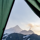
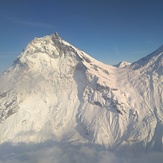
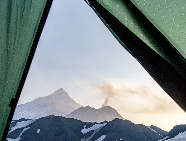
morning view out of my tent on Kamen (background) and fuming Bezymianny
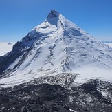
North Face of Kamen Volcano
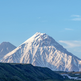
Kamen, the "Stone", in front of Kliuchevskoi
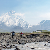
rivercrossings on Kamchatka should be done in morning hours
Vol.Kamen