
– Lat/Long: 36.30° N 137.64° E
 Hotakadake
Weather Forecast, JapanIssued: 2 pm Mon 03 Aug Local TimeUpdates in: hr min sUpdate imminent
Issued: 2 pm Mon 03 Aug Local Time
Updates in:
Update imminent hr min s

Issued: 2 pm Mon 03 Aug Local Time
Updates in:
Update imminent hr min s
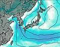
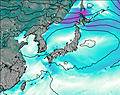
Days 1–4 Weather SummaryModerate rain (total 12mm), heaviest on Mon afternoon. Very mild (max 13°C on Tue afternoon, min 10°C on Wed afternoon). Wind will be generally light. | Days 5–7 Weather SummaryModerate rain (total 11mm), heaviest on Thu afternoon. Very mild (max 12°C on Thu night, min 10°C on Fri morning). Wind will be generally light. | ||||||||||||||||
Mon 3 | Tuesday 4 | Wednesday 5 | Thursday 6 | Friday 7 | Saturday 8 | ||||||||||||
PM | night | AM | PM | night | AM | PM | night | AM | PM | night | AM | PM | night | AM | PM | night | |
risk tstorm | rain shwrs | rain shwrs | rain shwrs | rain shwrs | clear | rain shwrs | rain shwrs | rain shwrs | risk tstorm | rain shwrs | clear | rain shwrs | rain shwrs | rain shwrs | risk tstorm | rain shwrs | |
Cloud base (m) | 2000 | 1700 | 1850 | 2200 | 2600 | 1700 | 1700 | 2550 | 1750 | 1700 | 2050 | 1950 | |||||
km/h | |||||||||||||||||
 |  |  |  |  |  | ||||||||||||
— | — | — | — | — | — | — | — | — | — | — | — | — | — | — | — | — | |
mm | 10 | 0.7 | 0.5 | 0.8 | 0.1 | — | 0.2 | 0.2 | 0.2 | 4 | 0.4 | — | 0.4 | 0.3 | 0.8 | 4 | 0.7 |
max °C | 12 | 12 | 12 | 13 | 13 | 12 | 10 | 12 | 11 | 11 | 12 | 11 | 10 | 11 | 11 | 10 | 11 |
min °C | 12 | 11 | 12 | 11 | 13 | 11 | 10 | 11 | 11 | 11 | 11 | 10 | 10 | 10 | 10 | 10 | 10 |
chill °C | 12 | 11 | 10 | 11 | 12 | 10 | 9 | 10 | 10 | 10 | 9 | 10 | 9 | 8 | 10 | 10 | 9 |
Freezing level m | 5550 | 5500 | 5450 | 5400 | 5600 | 5500 | 5400 | 5450 | 5400 | 5350 | 5350 | 5300 | 5200 | 5250 | 5200 | 5150 | 5100 |
— | — | 4:58 | — | — | 4:58 | — | — | 4:58 | — | — | 5:00 | — | — | 5:01 | — | — | |
6:52 | — | — | 6:52 | — | — | 6:51 | — | — | 6:50 | — | — | 6:49 | — | — | 6:47 | — | |
Loading...
Hotakadake Weather (Days 0-3):
The weather forecast for Hotakadake is: Moderate rain (total 12mm), heaviest on Mon afternoon. Very mild (max 13°C on Tue afternoon, min 10°C on Wed afternoon). Wind will be generally light.
Hotakadake Weather (Days 3-6):
Moderate rain (total 11mm), heaviest on Thu afternoon. Very mild (max 12°C on Thu night, min 10°C on Fri morning). Wind will be generally light.
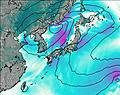
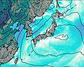
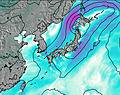
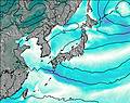
This table gives the weather forecast for Hotakadake at the specific elevation of 3190 m. Our advanced weather models allow us to provide distinct weather forecasts for several elevations of Hotakadake. To see the weather forecasts for the other elevations, use the tab navigation above the table. For a wider overview of the weather, consult the Weather Map of Japan.
| Weather Station | Temp. | Weather | Wind | Gusts | Cloud / Visibility |
|---|---|---|---|---|---|
Matsumoto Airport | |||||
lightning 27km NW of Nakatsugawa |
* NOTE: not all weather observatories update at the same frequency which is the reason why some locations may show data from stations that are further away than known closer ones.
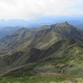
Hotakadake Photos
View all
Honshu photos (153) |
Japanese Archipelago photos (294) |
photos from mountains in Japan (376) |
all photos
 Upload new photo
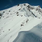


 See 9 more Hotakadake photos
厳冬期 谷川岳(西黒尾根)
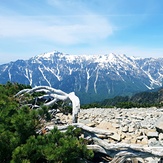
View from Mt. Hotaka
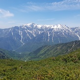
Hotaka June 2019
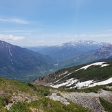
Hotaka June 2019
Hotaka June 2019
Hotaka June 2019