– Lat/Long: 54.53° N 3.02° W
 Helvellyn
Weather Forecast, United KingdomIssued: 12 pm Mon 03 Aug Local TimeUpdates in: hr min sUpdate imminent
Issued: 12 pm Mon 03 Aug Local Time
Updates in:
Update imminent hr min s

Issued: 12 pm Mon 03 Aug Local Time
Updates in:
Update imminent hr min s
Days 1–3 Weather SummaryModerate rain (total 12mm), heaviest on Tue night. Very mild (max 16°C on Mon afternoon, min 8°C on Wed morning). Winds increasing (moderate winds from the SSW on Mon night, near gales from the W by Wed afternoon). | Days 4–6 Weather SummarySome drizzle, heaviest during Sat afternoon. Very mild (max 11°C on Sat afternoon, min 7°C on Thu morning). Mainly strong winds. | |||||||||||||||||
Monday 3 | Tuesday 4 | Wednesday 5 | Thursday 6 | Friday 7 | Saturday 8 | |||||||||||||
AM | PM | night | AM | PM | night | AM | PM | night | AM | PM | night | AM | PM | night | AM | PM | night | |
some clouds | cloudy | light rain | light rain | risk tstorm | rain shwrs | light rain | light rain | light rain | rain shwrs | rain shwrs | some clouds | some clouds | some clouds | some clouds | light rain | light rain | some clouds | |
Cloud base (m) | 1650 | 1800 | 1650 | 1800 | 350 | 500 | 350 | 250 | 300 | 400 | 850 | 750 | 700 | 5700 | 5250 | 500 | 350 | 350 |
km/h | ||||||||||||||||||
 |  |  |  |  |  | |||||||||||||
— | — | — | — | — | — | — | — | — | — | — | — | — | — | — | — | — | — | |
mm | — | — | 3 | 0.4 | 1.5 | 2 | 1.5 | 2 | 1.1 | 0.3 | 0.3 | — | — | — | — | 0.2 | 0.7 | — |
max °C | 13 | 16 | 13 | 14 | 14 | 12 | 8 | 9 | 9 | 8 | 9 | 8 | 9 | 10 | 9 | 10 | 11 | 11 |
min °C | 12 | 16 | 13 | 13 | 14 | 9 | 8 | 8 | 8 | 7 | 8 | 7 | 9 | 10 | 8 | 10 | 10 | 10 |
chill °C | 9 | 14 | 11 | 11 | 12 | 5 | 4 | 3 | 4 | 3 | 4 | 3 | 6 | 7 | 5 | 6 | 6 | 6 |
Freezing level m | 2900 | 3250 | 3400 | 3500 | 3400 | 3200 | 2450 | 2600 | 2550 | 2350 | 2500 | 2700 | 2550 | 2600 | 2750 | 3050 | 3350 | 3400 |
5:24 | — | — | 5:26 | — | — | 5:28 | — | — | 5:30 | — | — | 5:31 | — | — | 5:33 | — | — | |
— | 9:08 | — | — | 9:07 | — | — | 9:05 | — | — | 9:04 | — | — | 9:01 | — | — | 8:59 | — | |
Loading...
Helvellyn Weather (Days 0-3):
The weather forecast for Helvellyn is: Moderate rain (total 12mm), heaviest on Tue night. Very mild (max 16°C on Mon afternoon, min 8°C on Wed morning). Winds increasing (moderate winds from the SSW on Mon night, near gales from the W by Wed afternoon).
Helvellyn Weather (Days 3-6):
Some drizzle, heaviest during Sat afternoon. Very mild (max 11°C on Sat afternoon, min 7°C on Thu morning). Mainly strong winds.
This table gives the weather forecast for Helvellyn at the specific elevation of 950 m. Our advanced weather models allow us to provide distinct weather forecasts for several elevations of Helvellyn. To see the weather forecasts for the other elevations, use the tab navigation above the table. For a wider overview of the weather, consult the Weather Map of United Kingdom.
| Weather Station | Temp. | Weather | Wind | Gusts | Cloud / Visibility |
|---|---|---|---|---|---|
Shap | |||||
SHIP591 | |||||
SHIP4810 | |||||
SHIP925 | |||||
SHIP483 | |||||
SHIP3961 | |||||
SHIP5847 |
* NOTE: not all weather observatories update at the same frequency which is the reason why some locations may show data from stations that are further away than known closer ones.
Helvellyn Photos
View all
photos (729) |
Lake District photos (738) |
photos from mountains in United Kingdom (2125) |
all photos
 Upload new photo
 See 40 more Helvellyn photos
Ullswater
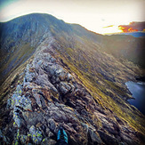
Striding Edge
Sunrise
Striding edge at sunset
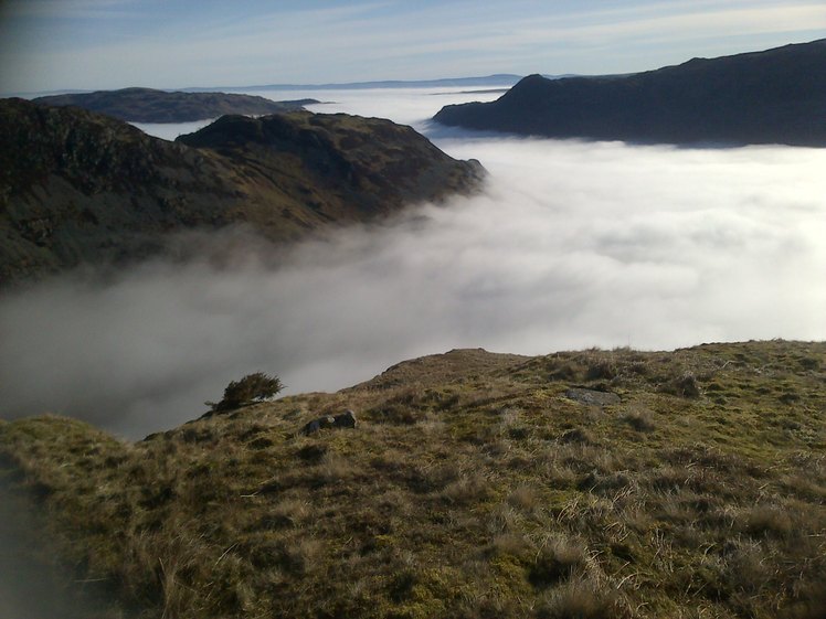
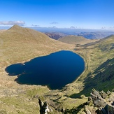
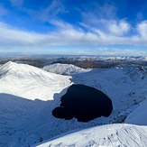
Red tarn from Helvellyn
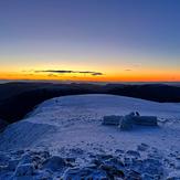
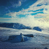
Helvellyn summit shelter
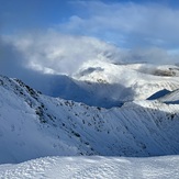
View from Helvellyn towards Swirral Edge