– Lat/Long: 46.58° N 8.01° E
 Eiger
Eiger
Weather Forecast, SwitzerlandIssued: 1 pm Mon 03 Aug Local TimeUpdates in: hr min sUpdate imminent
Issued: 1 pm Mon 03 Aug Local Time
Updates in:
Update imminent hr min s

Issued: 1 pm Mon 03 Aug Local Time
Updates in:
Update imminent hr min s
Days 1–4 Weather SummaryModerate rain (total 17mm), heaviest on Wed afternoon. Temperatures will be slightly above freezing (max 4°C on Mon afternoon, min 2°C on Tue morning). Wind will be generally light. | Days 5–7 Weather SummaryMild at first with light rain (total 2mm) on Thu afternoon followed by colder weather and light fall of snow, heaviest on Thu night. Freeze-thaw conditions (max 3°C on Thu afternoon, min 0°C on Thu night). Wind will be generally light. | ||||||||||||||||
Mon 3 | Tuesday 4 | Wednesday 5 | Thursday 6 | Friday 7 | Saturday 8 | ||||||||||||
PM | night | AM | PM | night | AM | PM | night | AM | PM | night | AM | PM | night | AM | PM | night | |
risk tstorm | risk tstorm | clear | risk tstorm | rain shwrs | clear | risk tstorm | rain shwrs | rain shwrs | snow shwrs | snow shwrs | clear | clear | clear | clear | clear | clear | |
Cloud base (m) | 4500 | 4800 | 2800 | 2700 | 2750 | 2700 | 2700 | 3000 | 2950 | ||||||||
km/h | |||||||||||||||||
 |  |  |  |  |  | ||||||||||||
— | — | — | — | — | — | — | — | — | 2 | 8 | — | — | — | — | — | — | |
mm | 0.7 | 3 | — | 1.2 | 4 | — | 4 | 4 | 0.4 | 2 | — | — | — | — | — | — | — |
max °C | 4 | 3 | 3 | 3 | 3 | 2 | 3 | 3 | 2 | 3 | 1 | 1 | 1 | 1 | 1 | 2 | 3 |
min °C | 4 | 3 | 2 | 3 | 2 | 2 | 3 | 2 | 2 | 2 | 0 | 0 | 0 | 1 | 1 | 2 | 2 |
chill °C | 2 | 0 | -2 | -1 | 0 | 0 | 1 | 0 | -1 | -1 | -2 | -3 | -3 | -3 | -3 | -1 | -2 |
Freezing level m | 4550 | 4450 | 4350 | 4500 | 4400 | 4350 | 4400 | 4400 | 4300 | 4250 | 4050 | 4050 | 4100 | 4200 | 4150 | 4200 | 4350 |
— | — | 6:11 | — | — | 6:11 | — | — | 6:13 | — | — | 6:15 | — | — | 6:16 | — | — | |
— | 8:57 | — | — | 8:55 | — | — | 8:53 | — | — | 8:52 | — | — | 8:51 | — | — | 8:50 | |
Loading...
Eiger Weather (Days 0-3):
The weather forecast for Eiger is: Moderate rain (total 17mm), heaviest on Wed afternoon. Temperatures will be slightly above freezing (max 4°C on Mon afternoon, min 2°C on Tue morning). Wind will be generally light.
Eiger Weather (Days 3-6):
Mild at first with light rain (total 2mm) on Thu afternoon followed by colder weather and light fall of snow, heaviest on Thu night. Freeze-thaw conditions (max 3°C on Thu afternoon, min 0°C on Thu night). Wind will be generally light.
This table gives the weather forecast for Eiger at the specific elevation of 3970 m. Our advanced weather models allow us to provide distinct weather forecasts for several elevations of Eiger. To see the weather forecasts for the other elevations, use the tab navigation above the table. For a wider overview of the weather, consult the Weather Map of Switzerland.
| Weather Station | Temp. | Weather | Wind | Gusts | Cloud / Visibility |
|---|---|---|---|---|---|
Schiltgrat | |||||
Höhematte holfuy | |||||
Lehn holfuy | |||||
lightning 15km SE of Meiringen | |||||
Amisbühl holfuy | |||||
Meiringen Airport |
* NOTE: not all weather observatories update at the same frequency which is the reason why some locations may show data from stations that are further away than known closer ones.
Eiger Photos
View all
Bernese Alps photos (163) |
Alps photos (1485) |
photos from mountains in Switzerland (649) |
all photos
 Upload new photo
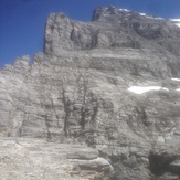
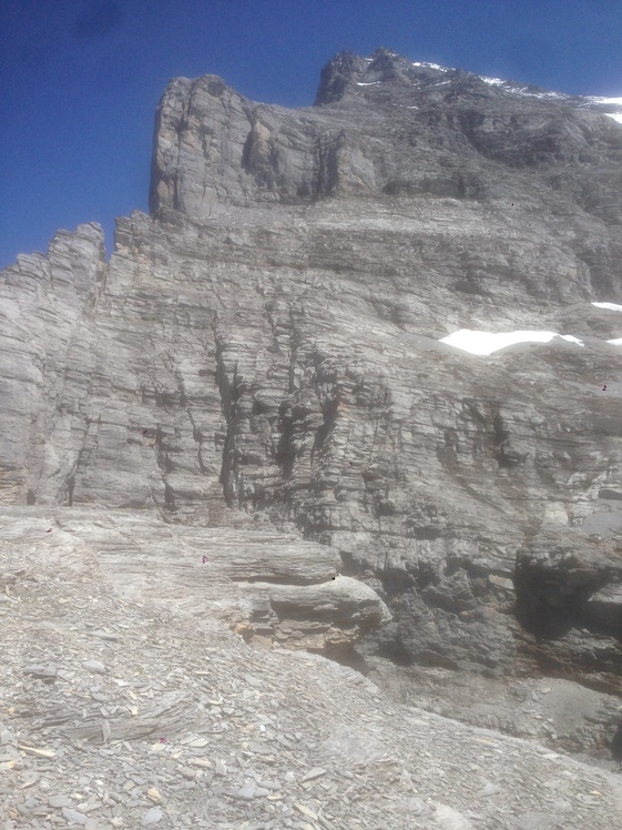
Eiger west ridge
Eiger North/West ridge
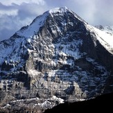
Eiger