– Lat/Long: 56.46° N 5.78° W
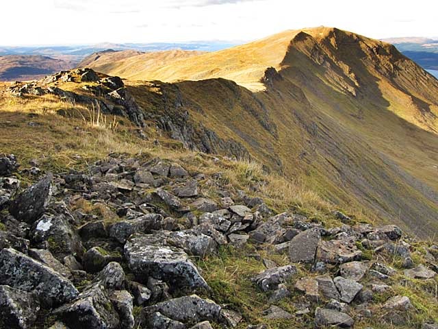
 Dùn da Ghaoithe (Dun da Ghaoithe)
Weather Forecast, United KingdomIssued: 5 pm Sat 21 Mar Local TimeUpdates in: hr min sUpdate imminent
Issued: 5 pm Sat 21 Mar Local Time
Updates in:
Update imminent hr min s

Issued: 5 pm Sat 21 Mar Local Time
Updates in:
Update imminent hr min s
Days 1–4 Weather SummaryA dusting of snow giving way to moderate rain (total 19mm) heaviest on Mon night. Freeze-thaw conditions (max 6°C on Mon night, min -1°C on Sun night). Winds increasing (light winds from the WSW on Sun night, gales from the W by Tue morning). | Days 5–7 Weather SummaryA light covering of new snow mostly falling on Tue afternoon. Becoming milder with moderate rain (total 12mm) heaviest on Thu night. Freeze-thaw conditions (max 3°C on Thu afternoon, min -4°C on Wed night). Winds decreasing (gales from the W on Tue afternoon, light winds from the WNW by Wed night). | ||||||||||||||||
Sat 21 | Sunday 22 | Monday 23 | Tuesday 24 | Wednesday 25 | Thursday 26 | ||||||||||||
PM | night | AM | PM | night | AM | PM | night | AM | PM | night | AM | PM | night | AM | PM | night | |
some clouds | light rain | rain shwrs | some clouds | some clouds | cloudy | light snow | heavy rain | some clouds | light snow | snow shwrs | snow shwrs | clear | some clouds | light snow | light snow | mod. rain | |
km/h | |||||||||||||||||
 |  |  |  |  |  | ||||||||||||
— | — | — | — | — | — | 1 | — | — | 1 | 3 | 1 | — | — | 1 | 1 | — | |
— | 0.9 | 0.7 | — | — | — | 2 | 16 | — | — | — | — | — | — | — | 3 | 9 | |
max °C | 4 | 4 | 3 | 1 | -1 | 1 | 4 | 6 | 1 | -1 | -2 | -1 | -1 | -3 | 1 | 3 | 3 |
min °C | 4 | 4 | 1 | 0 | -1 | 0 | 1 | 3 | 1 | -1 | -2 | -2 | -2 | -4 | -1 | 2 | 0 |
0 | -1 | -5 | -7 | -8 | -6 | -6 | -5 | -8 | -11 | -12 | -11 | -10 | -10 | -7 | -4 | -5 | |
1850 | 1500 | 1350 | 850 | 600 | 750 | 1050 | 2000 | 900 | 700 | 450 | 550 | 600 | 350 | 550 | 2000 | 1300 | |
Cloud base (m) | 200 | 500 | 200 | 400 | 500 | 600 | 300 | 200 | 400 | 500 | 300 | 250 | 500 | 200 | 300 | 200 | 200 |
— | — | 6:20 | — | — | 6:16 | — | — | 6:13 | — | — | 6:11 | — | — | 6:09 | — | — | |
6:37 | — | — | 6:40 | — | — | 6:43 | — | — | 6:45 | — | — | 6:46 | — | — | 6:49 | — | |
Loading...
Dùn da Ghaoithe Weather (Days 0-3):
The weather forecast for Dùn da Ghaoithe is: A dusting of snow giving way to moderate rain (total 19mm) heaviest on Mon night. Freeze-thaw conditions (max 6°C on Mon night, min -1°C on Sun night). Winds increasing (light winds from the WSW on Sun night, gales from the W by Tue morning).
Dùn da Ghaoithe Weather (Days 3-6):
A light covering of new snow mostly falling on Tue afternoon. Becoming milder with moderate rain (total 12mm) heaviest on Thu night. Freeze-thaw conditions (max 3°C on Thu afternoon, min -4°C on Wed night). Winds decreasing (gales from the W on Tue afternoon, light winds from the WNW by Wed night).
This table gives the weather forecast for Dùn da Ghaoithe at the specific elevation of 766 m. Our advanced weather models allow us to provide distinct weather forecasts for several elevations of Dùn da Ghaoithe. To see the weather forecasts for the other elevations, use the tab navigation above the table. For a wider overview of the weather, consult the Weather Map of United Kingdom.
Dùn da Ghaoithe Photos
View all
Northwest Highlands photos (39) |
Scottish Highlands photos (298) |
photos from mountains in United Kingdom (2110) |
all photos
 Upload new photo
Dùn da Ghaoithe