– Lat/Long: 45.14° N 6.15° E
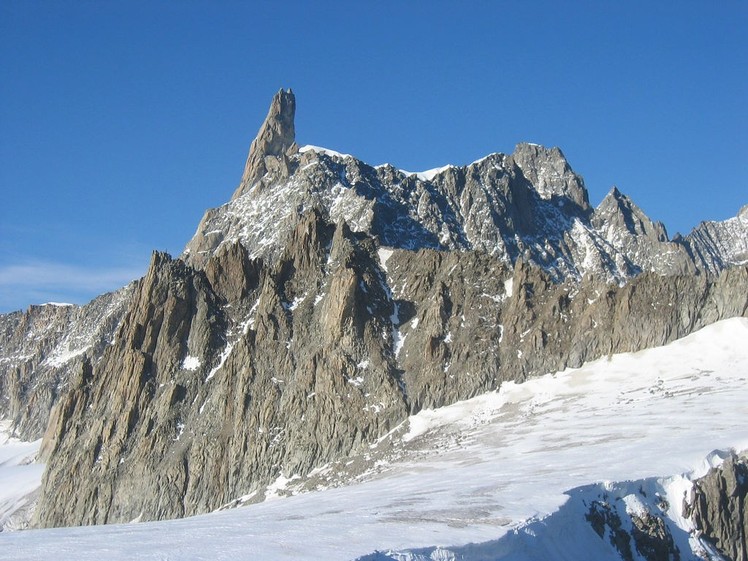
 Dent du Géant (Dent du Geant)
Weather Forecast, FranceIssued: 1 am Mon 13 Jul Local TimeUpdates in: hr min sUpdate imminent
Issued: 1 am Mon 13 Jul Local Time
Updates in:
Update imminent hr min s

Issued: 1 am Mon 13 Jul Local Time
Updates in:
Update imminent hr min s
Days 1–3 Weather SummaryLight rain (total 5mm), mostly falling on Wed night. Mild temperatures (max 6°C on Wed afternoon, min 3°C on Mon night). Winds increasing (light winds from the W on Mon night, strong winds from the WSW by Wed afternoon). | Days 4–6 Weather SummaryModerate rain (total 15mm), heaviest on Thu afternoon. Freeze-thaw conditions (max 4°C on Thu morning, min 0°C on Sat morning). Winds decreasing (strong winds from the WSW on Thu afternoon, light winds from the W by Sat morning). | |||||||||||||||||
Monday 13 | Tuesday 14 | Wednesday 15 | Thursday 16 | Friday 17 | Saturday 18 | |||||||||||||
AM | PM | night | AM | PM | night | AM | PM | night | AM | PM | night | AM | PM | night | AM | PM | night | |
some clouds | some clouds | clear | clear | clear | clear | clear | some clouds | risk tstorm | clear | risk tstorm | rain shwrs | risk tstorm | rain shwrs | risk tstorm | clear | clear | clear | |
km/h | ||||||||||||||||||
 |  |  |  |  |  | |||||||||||||
— | — | — | — | — | — | — | — | — | — | — | — | — | — | — | — | — | — | |
mm | — | — | — | — | — | — | — | — | 5 | — | 5 | 5 | 0.1 | 2 | 3 | — | — | — |
max °C | 5 | 5 | 4 | 4 | 4 | 4 | 4 | 6 | 4 | 4 | 4 | 4 | 3 | 3 | 2 | 1 | 0 | 1 |
min °C | 5 | 4 | 3 | 4 | 4 | 4 | 4 | 5 | 4 | 4 | 3 | 4 | 3 | 3 | 1 | 0 | 0 | 0 |
chill °C | 1 | -1 | -1 | 0 | -1 | 0 | -2 | 0 | -2 | -1 | -4 | -2 | -2 | -2 | -4 | -4 | -4 | -5 |
Freezing level m | 4650 | 4650 | 4500 | 4550 | 4650 | 4550 | 4550 | 4750 | 4600 | 4550 | 4600 | 4550 | 4400 | 4450 | 4250 | 4050 | 4100 | 4200 |
Cloud base (m) | 5650 | 5350 | 8650 | 9650 | 4900 | 9300 | 5550 | 4050 | 3600 | 8400 | 7250 | |||||||
6:00 | — | — | 6:01 | — | — | 6:01 | — | — | 6:01 | — | — | 6:03 | — | — | 6:03 | — | — | |
— | — | 9:21 | — | — | 9:20 | — | — | 9:20 | — | — | 9:19 | — | — | 9:17 | — | — | 9:16 | |
Loading...
Dent du Géant Weather (Days 0-3):
The weather forecast for Dent du Géant is: Light rain (total 5mm), mostly falling on Wed night. Mild temperatures (max 6°C on Wed afternoon, min 3°C on Mon night). Winds increasing (light winds from the W on Mon night, strong winds from the WSW by Wed afternoon).
Dent du Géant Weather (Days 3-6):
Moderate rain (total 15mm), heaviest on Thu afternoon. Freeze-thaw conditions (max 4°C on Thu morning, min 0°C on Sat morning). Winds decreasing (strong winds from the WSW on Thu afternoon, light winds from the W by Sat morning).
This table gives the weather forecast for Dent du Géant at the specific elevation of 4013 m. Our advanced weather models allow us to provide distinct weather forecasts for several elevations of Dent du Géant. To see the weather forecasts for the other elevations, use the tab navigation above the table. For a wider overview of the weather, consult the Weather Map of France.
Dent du Géant Photos
View all
Graian Alps photos (56) |
Alps photos (1484) |
photos from mountains in France (301) |
all photos
 Upload new photo
Dent du Géant