– Lat/Long: 45.29° N 5.79° E
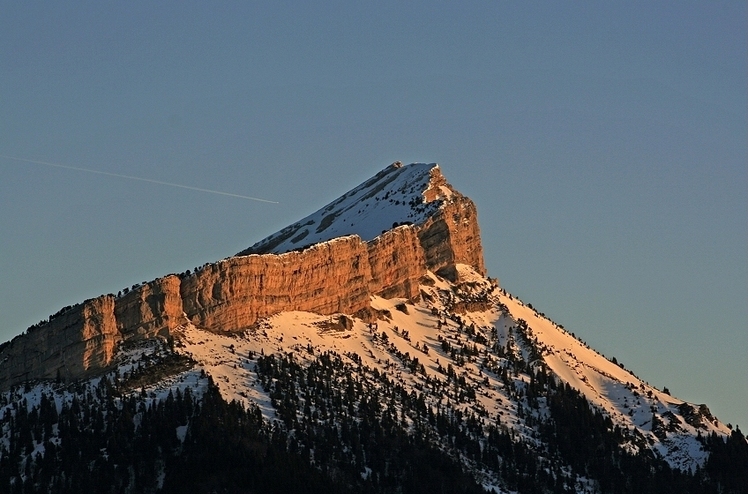
 Chamechaude
Weather Forecast, FranceIssued: 1 am Tue 14 Jul Local TimeUpdates in: hr min sUpdate imminent
Issued: 1 am Tue 14 Jul Local Time
Updates in:
Update imminent hr min s

Issued: 1 am Tue 14 Jul Local Time
Updates in:
Update imminent hr min s
Days 1–3 Weather SummaryModerate rain (total 12mm), heaviest on Thu night. Warm (max 21°C on Wed afternoon, min 14°C on Thu night). Winds increasing (calm on Tue morning, fresh winds from the SW by Thu night). | Days 4–6 Weather SummaryLight rain (total 2mm), mostly falling on Fri night. Very mild (max 17°C on Fri afternoon, min 11°C on Sun morning). Wind will be generally light. | |||||||||||||||||
Tuesday 14 | Wednesday 15 | Thursday 16 | Friday 17 | Saturday 18 | Sunday 19 | |||||||||||||
AM | PM | night | AM | PM | night | AM | PM | night | AM | PM | night | AM | PM | night | AM | PM | night | |
clear | clear | clear | clear | rain shwrs | risk tstorm | clear | some clouds | risk tstorm | some clouds | some clouds | risk tstorm | clear | clear | clear | clear | clear | clear | |
km/h | ||||||||||||||||||
 |  |  |  |  |  | |||||||||||||
— | — | — | — | — | — | — | — | — | — | — | — | — | — | — | — | — | — | |
mm | — | — | — | — | 0.2 | 1.2 | — | — | 10 | — | — | 2 | — | — | — | — | — | — |
max °C | 16 | 19 | 19 | 20 | 21 | 18 | 19 | 20 | 18 | 15 | 17 | 15 | 12 | 14 | 14 | 11 | 13 | 13 |
min °C | 15 | 18 | 18 | 19 | 18 | 16 | 19 | 19 | 14 | 15 | 17 | 13 | 12 | 13 | 12 | 11 | 12 | 12 |
chill °C | 15 | 18 | 18 | 19 | 18 | 16 | 19 | 19 | 12 | 14 | 16 | 12 | 11 | 13 | 11 | 10 | 10 | 10 |
Freezing level m | 4500 | 4450 | 4500 | 4500 | 4650 | 4550 | 4500 | 4650 | 4500 | 4400 | 4300 | 4150 | 3850 | 3750 | 3850 | 3500 | 3600 | 3850 |
Cloud base (m) | 8650 | 9100 | 8200 | 3750 | 9550 | 3950 | 5800 | 4500 | 3550 | 9100 | ||||||||
6:01 | — | — | 6:01 | — | — | 6:03 | — | — | 6:03 | — | — | 6:05 | — | — | 6:05 | — | — | |
— | — | 9:22 | — | — | 9:22 | — | — | 9:21 | — | — | 9:20 | — | — | 9:19 | — | — | 9:19 | |
Loading...
Chamechaude Weather (Days 0-3):
The weather forecast for Chamechaude is: Moderate rain (total 12mm), heaviest on Thu night. Warm (max 21°C on Wed afternoon, min 14°C on Thu night). Winds increasing (calm on Tue morning, fresh winds from the SW by Thu night).
Chamechaude Weather (Days 3-6):
Light rain (total 2mm), mostly falling on Fri night. Very mild (max 17°C on Fri afternoon, min 11°C on Sun morning). Wind will be generally light.
This table gives the weather forecast for Chamechaude at the specific elevation of 2082 m. Our advanced weather models allow us to provide distinct weather forecasts for several elevations of Chamechaude. To see the weather forecasts for the other elevations, use the tab navigation above the table. For a wider overview of the weather, consult the Weather Map of France.
| Weather Station | Temp. | Weather | Wind | Gusts | Cloud / Visibility |
|---|---|---|---|---|---|
TMX clos giraud g2 | |||||
TC Montfrais g4 | |||||
Aéroport Grenoble-Isère Grenobl / aint Geoirs Airport | |||||
Col roc de Fer | |||||
1309 | |||||
G2 Bouquetin | |||||
G2 Cote Brune | |||||
TC GRANGETTES P4 | |||||
G4 Pas du Lac |
* NOTE: not all weather observatories update at the same frequency which is the reason why some locations may show data from stations that are further away than known closer ones.
Chamechaude Photos
View all
Chartreuse Mountains photos (2) |
Alps photos (1484) |
photos from mountains in France (301) |
all photos
 Upload new photo
Chamechaude