– Lat/Long: 42.57° N 1.93° E
 Carlit
Weather Forecast, FranceIssued: 1 pm Mon 03 Aug Local TimeUpdates in: hr min sUpdate imminent
Issued: 1 pm Mon 03 Aug Local Time
Updates in:
Update imminent hr min s

Issued: 1 pm Mon 03 Aug Local Time
Updates in:
Update imminent hr min s
Days 1–4 Weather SummaryModerate rain (total 12mm), heaviest on Mon night. Very mild (max 13°C on Mon afternoon, min 7°C on Mon night). Winds decreasing (fresh winds from the SSW on Mon night, calm by Tue night). | Days 5–7 Weather SummaryHeavy rain (total 31mm), heaviest during Sat night. Very mild (max 13°C on Sat afternoon, min 9°C on Thu night). Wind will be generally light. | ||||||||||||||||
Mon 3 | Tuesday 4 | Wednesday 5 | Thursday 6 | Friday 7 | Saturday 8 | ||||||||||||
PM | night | AM | PM | night | AM | PM | night | AM | PM | night | AM | PM | night | AM | PM | night | |
some clouds | risk tstorm | clear | light rain | rain shwrs | clear | light rain | risk tstorm | rain shwrs | mod. rain | risk tstorm | rain shwrs | risk tstorm | rain shwrs | clear | light rain | risk tstorm | |
Cloud base (m) | 6000 | 5350 | 4000 | 3650 | 3250 | 2650 | 2050 | 3000 | 4400 | ||||||||
km/h | |||||||||||||||||
 |  |  |  |  |  | ||||||||||||
— | — | — | — | — | — | — | — | — | — | — | — | — | — | — | — | — | |
mm | — | 4 | — | 0.2 | 0.6 | — | 1.2 | 3 | 3 | 9 | 7 | 0.2 | 5 | 0.8 | — | 0.1 | 9 |
max °C | 13 | 11 | 9 | 11 | 10 | 10 | 12 | 10 | 10 | 10 | 10 | 10 | 10 | 10 | 11 | 13 | 12 |
min °C | 12 | 7 | 8 | 10 | 9 | 10 | 11 | 10 | 10 | 10 | 9 | 9 | 10 | 9 | 10 | 12 | 10 |
chill °C | 10 | 5 | 6 | 9 | 8 | 10 | 9 | 8 | 7 | 8 | 6 | 6 | 8 | 7 | 7 | 12 | 10 |
Freezing level m | 4650 | 4100 | 4200 | 4500 | 4450 | 4500 | 4600 | 4550 | 4350 | 4450 | 4550 | 4450 | 4450 | 4550 | 4600 | 4700 | 4700 |
— | — | 6:46 | — | — | 6:47 | — | — | 6:48 | — | — | 6:48 | — | — | 6:50 | — | — | |
— | 9:09 | — | — | 9:08 | — | — | 9:07 | — | — | 9:06 | — | — | 9:05 | — | — | 9:04 | |
Loading...
Carlit Weather (Days 0-3):
The weather forecast for Carlit is: Moderate rain (total 12mm), heaviest on Mon night. Very mild (max 13°C on Mon afternoon, min 7°C on Mon night). Winds decreasing (fresh winds from the SSW on Mon night, calm by Tue night).
Carlit Weather (Days 3-6):
Heavy rain (total 31mm), heaviest during Sat night. Very mild (max 13°C on Sat afternoon, min 9°C on Thu night). Wind will be generally light.
This table gives the weather forecast for Carlit at the specific elevation of 2921 m. Our advanced weather models allow us to provide distinct weather forecasts for several elevations of Carlit. To see the weather forecasts for the other elevations, use the tab navigation above the table. For a wider overview of the weather, consult the Weather Map of France.
| Weather Station | Temp. | Weather | Wind | Gusts | Cloud / Visibility |
|---|---|---|---|---|---|
La Molina | |||||
Cap del Rec | |||||
thunderstorm affecting Belesta | |||||
lightning 8km W of Quillan | |||||
lightning 8km ESE of Chalabre | |||||
lightning 8km W of Esperaza | |||||
lightning 8km NW of Arinsal | |||||
lightning 13km SW of Tarascon-sur-Ariege | |||||
lightning 15km W of Andorra La Vella | |||||
* NOTE: not all weather observatories update at the same frequency which is the reason why some locations may show data from stations that are further away than known closer ones.
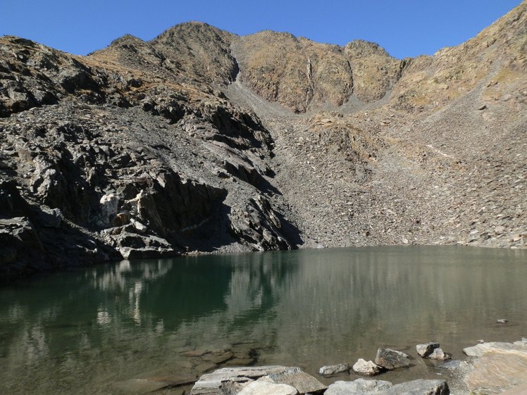
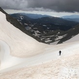
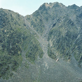
Carlit Photos
View all
photos (101) |
Pyrenees photos (143) |
photos from mountains in France (302) |
all photos
 Upload new photo
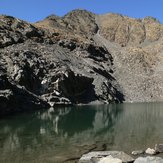
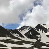
Carlit
Dernier tronçon, sur la neige
Carlit
Pic Carlit 2921
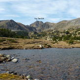
A view of the Carlit