– Lat/Long: 45.93° N 7.73° E
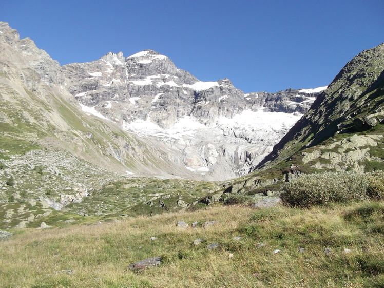
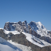
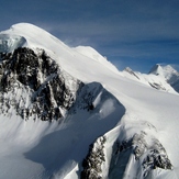
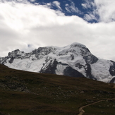
 Breithorn
Weather Forecast, SwitzerlandIssued: 1 pm Mon 03 Aug Local TimeUpdates in: hr min sUpdate imminent
Issued: 1 pm Mon 03 Aug Local Time
Updates in:
Update imminent hr min s

Issued: 1 pm Mon 03 Aug Local Time
Updates in:
Update imminent hr min s
Days 1–4 Weather SummaryMild at first with light rain (total 8mm) on Wed afternoon followed by colder weather and light fall of snow, heaviest on Wed night. Temperatures will be slightly above freezing (max 3°C on Wed afternoon, min 1°C on Mon night). Wind will be generally light. | Days 5–7 Weather SummaryDrizzle, on Thu afternoon followed by colder weather and a moderate fall of snow, heaviest on Thu night.. Freeze-thaw conditions (max 3°C on Thu afternoon, min 0°C on Thu night). Wind will be generally light. | ||||||||||||||||
Mon 3 | Tuesday 4 | Wednesday 5 | Thursday 6 | Friday 7 | Saturday 8 | ||||||||||||
PM | night | AM | PM | night | AM | PM | night | AM | PM | night | AM | PM | night | AM | PM | night | |
risk tstorm | snow shwrs | clear | snow shwrs | snow shwrs | clear | rain shwrs | snow shwrs | clear | snow shwrs | snow shwrs | clear | snow shwrs | snow shwrs | clear | snow shwrs | snow shwrs | |
Cloud base (m) | 4000 | 4850 | 4650 | 4350 | 3900 | 2850 | 3700 | ||||||||||
km/h | |||||||||||||||||
 |  |  |  |  |  | ||||||||||||
— | 1 | — | 1 | 2 | — | — | 7 | — | 2 | 7 | — | 2 | 1 | — | 1 | 1 | |
mm | 4 | — | — | — | 1.5 | — | 3 | — | — | 1 | — | — | — | — | — | — | — |
max °C | 2 | 1 | 1 | 2 | 2 | 2 | 3 | 2 | 2 | 3 | 1 | 0 | 1 | 1 | 1 | 2 | 2 |
min °C | 2 | 1 | 1 | 2 | 2 | 1 | 2 | 1 | 1 | 2 | 0 | 0 | 1 | 0 | 0 | 2 | 1 |
chill °C | -2 | -3 | -3 | -3 | -1 | 1 | 1 | -2 | -2 | -1 | -3 | -4 | -3 | -4 | -4 | -2 | -3 |
Freezing level m | 4500 | 4400 | 4400 | 4450 | 4450 | 4500 | 4550 | 4450 | 4400 | 4400 | 4250 | 4200 | 4400 | 4250 | 4350 | 4450 | 4350 |
— | — | 6:13 | — | — | 6:15 | — | — | 6:16 | — | — | 6:18 | — | — | 6:18 | — | — | |
— | 8:55 | — | — | 8:54 | — | — | 8:52 | — | — | 8:52 | — | — | 8:51 | — | — | 8:49 | |
Loading...
Breithorn Weather (Days 0-3):
The weather forecast for Breithorn is: Mild at first with light rain (total 8mm) on Wed afternoon followed by colder weather and light fall of snow, heaviest on Wed night. Temperatures will be slightly above freezing (max 3°C on Wed afternoon, min 1°C on Mon night). Wind will be generally light.
Breithorn Weather (Days 3-6):
Drizzle, on Thu afternoon followed by colder weather and a moderate fall of snow, heaviest on Thu night.. Freeze-thaw conditions (max 3°C on Thu afternoon, min 0°C on Thu night). Wind will be generally light.
This table gives the weather forecast for Breithorn at the specific elevation of 4164 m. Our advanced weather models allow us to provide distinct weather forecasts for several elevations of Breithorn. To see the weather forecasts for the other elevations, use the tab navigation above the table. For a wider overview of the weather, consult the Weather Map of Switzerland.
| Weather Station | Temp. | Weather | Wind | Gusts | Cloud / Visibility |
|---|---|---|---|---|---|
ZFC: Kl. Matterhorn | |||||
ZFC: Schwarzsee | |||||
ZFC: Landing Zermatt | |||||
lightning 8km WSW of Zermatt | |||||
ZFC: Gornergrat N. | |||||
ZFC: Riffelberg | |||||
ZFC: Gornergr. North | |||||
lightning 10km NW of Valtournenche | |||||
lightning 10km SE of Evolene | |||||
* NOTE: not all weather observatories update at the same frequency which is the reason why some locations may show data from stations that are further away than known closer ones.
Breithorn Photos
View all
Pennine Alps photos (202) |
Alps photos (1485) |
photos from mountains in Switzerland (649) |
all photos
 Upload new photo
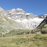
Hindri Jegi
Breithorn group
Breithorn
Breithorn