
– Lat/Long: 4.80° N 9.71° E
 Bakossi Mountains
Weather Forecast, CameroonIssued: 6 pm Sun 02 Aug Local TimeUpdates in: hr min sUpdate imminent
Issued: 6 pm Sun 02 Aug Local Time
Updates in:
Update imminent hr min s

Issued: 6 pm Sun 02 Aug Local Time
Updates in:
Update imminent hr min s
Days 1–4 Weather SummaryHeavy rain (total 31mm), heaviest during Sun afternoon. Warm (max 25°C on Tue morning, min 21°C on Sun night). Wind will be generally light. | Days 5–7 Weather SummaryHeavy rain (total 44mm), heaviest during Wed afternoon. Warm (max 24°C on Fri morning, min 21°C on Wed night). Wind will be generally light. | ||||||||||||||||
Sun 2 | Monday 3 | Tuesday 4 | Wednesday 5 | Thursday 6 | Friday 7 | ||||||||||||
PM | night | AM | PM | night | AM | PM | night | AM | PM | night | AM | PM | night | AM | PM | night | |
risk tstorm | risk tstorm | risk tstorm | mod. rain | rain shwrs | rain shwrs | risk tstorm | risk tstorm | risk tstorm | risk tstorm | rain shwrs | risk tstorm | risk tstorm | rain shwrs | risk tstorm | mod. rain | rain shwrs | |
Cloud base (m) | 400 | 300 | 800 | 650 | 2050 | 800 | 750 | 400 | 650 | 450 | 550 | 700 | 400 | 500 | 300 | 650 | 250 |
km/h | |||||||||||||||||
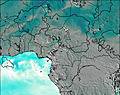 | 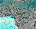 | 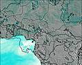 | 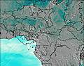 |  |  | ||||||||||||
— | — | — | — | — | — | — | — | — | — | — | — | — | — | — | — | — | |
mm | 9 | 3 | 4 | 5 | 0.3 | 0.3 | 0.6 | 1.5 | 6 | 8 | 0.9 | 5 | 6 | 0.8 | 3 | 9 | 4 |
max °C | 24 | 22 | 24 | 24 | 21 | 25 | 24 | 22 | 23 | 23 | 21 | 23 | 23 | 21 | 24 | 23 | 21 |
min °C | 22 | 21 | 23 | 22 | 21 | 22 | 23 | 21 | 23 | 22 | 21 | 23 | 22 | 21 | 22 | 22 | 21 |
chill °C | 22 | 21 | 23 | 22 | 21 | 22 | 23 | 21 | 23 | 22 | 21 | 23 | 22 | 21 | 22 | 22 | 21 |
Freezing level m | 4850 | 4800 | 4700 | 4700 | 4800 | 4750 | 4800 | 4800 | 4700 | 4850 | 4850 | 4750 | 4800 | 4850 | 4800 | 4800 | 4750 |
— | — | 6:16 | — | — | 6:16 | — | — | 6:16 | — | — | 6:16 | — | — | 6:16 | — | — | |
6:37 | — | — | 6:36 | — | — | 6:36 | — | — | 6:36 | — | — | 6:36 | — | — | 6:36 | — | |
Loading...
Bakossi Mountains Weather (Days 0-3):
The weather forecast for Bakossi Mountains is: Heavy rain (total 31mm), heaviest during Sun afternoon. Warm (max 25°C on Tue morning, min 21°C on Sun night). Wind will be generally light.
Bakossi Mountains Weather (Days 3-6):
Heavy rain (total 44mm), heaviest during Wed afternoon. Warm (max 24°C on Fri morning, min 21°C on Wed night). Wind will be generally light.
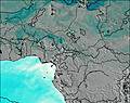
This table gives the weather forecast for Bakossi Mountains at the specific elevation of 500 m. Our advanced weather models allow us to provide distinct weather forecasts for several elevations of Bakossi Mountains. To see the weather forecasts for the other elevations, use the tab navigation above the table. For a wider overview of the weather, consult the Weather Map of Cameroon.
| Weather Station | Temp. | Weather | Wind | Gusts | Cloud / Visibility |
|---|---|---|---|---|---|
lightning 19km ENE of Akankpa | |||||
Bata (Rio Muni) | |||||
Bata Airport | |||||
lightning 54km SE of Beli | |||||
Oyem (Woleu-Ntem) | |||||
lightning 60km NNW of Bétaré Oya |
* NOTE: not all weather observatories update at the same frequency which is the reason why some locations may show data from stations that are further away than known closer ones.