Yonah Mountain Climbing Notes

Yonah Mountain climbing notes shared by Mountain-Forecast users
Click here to submit your own climbing note for Yonah Mountain
(NOTE: Texts may be edited by our content team for the purposes of ensuring accurate and relevant information)
-
November 22, 2015
Rick B 3 from United States
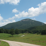
Yonah Mt., also called Mt. Yonah is in between the popular tourist town Helen and Cleveland. The out and back hike from the only parking lot is 4.4 miles round trip. Its' trail has several rugged portions with large boulders to scramble over. It is good to bring at least one hiking stick. Most folks can trek the whole route in around three hours. The view from the summit is better in the winter as the trees have dropped their leaves. The night view of the stars is outstanding on a clear night. Same with the full moon. Yes bring plenty of water, a litter bag, a weather radio, bug repellent, toilet paper, and know what poison ivy looks like. Of course leave no trace and leave it better than you found it. Plan for the worst and play for the best. First call the Army, who sometimes trains up there, so you will not be blocked out @ 706-864-3327 or 3367.
-
May 27, 2011
josh from United States
I have been to Yonah quite a few times in years past, but just recently discovered that there was a new parking lot and trail to hike. Before my most recent visit last weekend, I tried getting information on where the new lot is, how long and difficult the hike is, etc. and did not find very much information. This post is to help clear up any similar issues you may have about getting more info on the new lot and trail:
HOW TO GET TO THE NEW PARKING LOT:
From the north: Drive south on GA-75/Helen Hwy. Turn LEFT onto Tom Bell Road. Take your first LEFT onto Chambers road. In about 0.5 miles, you will see a gravel road on the left, marked by a yellow and brown sign saying Yonah.
From the south: Drive north on GA-75/Helen Hwy. Turn RIGHT onto Tom Bell Road. Take the second RIGHT onto Chambers Road. In about 0.5 miles, you will see a gravel road on the right, marked by a yellow and brown sign saying Yonah.
NEW TRAIL:
The trail head is very obvious - just before reaching the parking spaces, you will see it on your left. The trail is pretty scenic, but those new to hiking BE ADVISED: this is not the easiest trail to hike. It's approximately 1.5 miles long, and in this fairly short distance I believe there is an elevation gain of between 1,000 and 1,500 feet.
BRING ALOT OF WATER!!! For those who have never been, There is NO water source anywhere on this mountain. My fellow hikers and I brough a gallon of water each, and it was ALMOST enough for a 24 hour stay.
The normal trail brings you to the lower landing zone; It's a pretty large, flat, grassy area perfect for camping, has two fire rings (one near each end of this small field), and a nice rock to sit on and look out to the small nearby towns at night. If you continue along the trail it becomes extremely steep, but is the only way to get to the main face. Wish I had a dirt bike or 4-wheeler to get up it. This trail will lead you to the old gravel road; go right to continue up the road and it will bring you to the old parking lot, compete with a huge camping area, bathrooms, and connecting trails that lead to the main face.
I hope this helps answer some questions you may have about getting to your destination on Yonah. Happy hiking and happy climbing.
(NOTE: Texts may be edited by our content team for the purposes of ensuring accurate and relevant information)
Rick B 3 from United States
Yonah Mt., also called Mt. Yonah is in between the popular tourist town Helen and Cleveland. The out and back hike from the only parking lot is 4.4 miles round trip. Its' trail has several rugged portions with large boulders to scramble over. It is good to bring at least one hiking stick. Most folks can trek the whole route in around three hours. The view from the summit is better in the winter as the trees have dropped their leaves. The night view of the stars is outstanding on a clear night. Same with the full moon. Yes bring plenty of water, a litter bag, a weather radio, bug repellent, toilet paper, and know what poison ivy looks like. Of course leave no trace and leave it better than you found it. Plan for the worst and play for the best. First call the Army, who sometimes trains up there, so you will not be blocked out @ 706-864-3327 or 3367.
josh from United States
I have been to Yonah quite a few times in years past, but just recently discovered that there was a new parking lot and trail to hike. Before my most recent visit last weekend, I tried getting information on where the new lot is, how long and difficult the hike is, etc. and did not find very much information. This post is to help clear up any similar issues you may have about getting more info on the new lot and trail:
HOW TO GET TO THE NEW PARKING LOT:
From the north: Drive south on GA-75/Helen Hwy. Turn LEFT onto Tom Bell Road. Take your first LEFT onto Chambers road. In about 0.5 miles, you will see a gravel road on the left, marked by a yellow and brown sign saying Yonah.
From the south: Drive north on GA-75/Helen Hwy. Turn RIGHT onto Tom Bell Road. Take the second RIGHT onto Chambers Road. In about 0.5 miles, you will see a gravel road on the right, marked by a yellow and brown sign saying Yonah.
NEW TRAIL:
The trail head is very obvious - just before reaching the parking spaces, you will see it on your left. The trail is pretty scenic, but those new to hiking BE ADVISED: this is not the easiest trail to hike. It's approximately 1.5 miles long, and in this fairly short distance I believe there is an elevation gain of between 1,000 and 1,500 feet.
BRING ALOT OF WATER!!! For those who have never been, There is NO water source anywhere on this mountain. My fellow hikers and I brough a gallon of water each, and it was ALMOST enough for a 24 hour stay.
The normal trail brings you to the lower landing zone; It's a pretty large, flat, grassy area perfect for camping, has two fire rings (one near each end of this small field), and a nice rock to sit on and look out to the small nearby towns at night. If you continue along the trail it becomes extremely steep, but is the only way to get to the main face. Wish I had a dirt bike or 4-wheeler to get up it. This trail will lead you to the old gravel road; go right to continue up the road and it will bring you to the old parking lot, compete with a huge camping area, bathrooms, and connecting trails that lead to the main face.
I hope this helps answer some questions you may have about getting to your destination on Yonah. Happy hiking and happy climbing.