– Lat/Long: 54.40° N 3.12° W
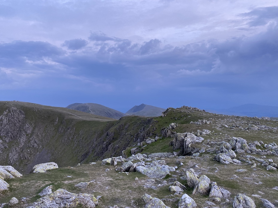
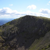
 Swirl How
Weather Forecast, United KingdomIssued: 12 am Sat 11 Jul Local TimeUpdates in: hr min sUpdate imminent
Issued: 12 am Sat 11 Jul Local Time
Updates in:
Update imminent hr min s

Issued: 12 am Sat 11 Jul Local Time
Updates in:
Update imminent hr min s
Days 1–4 Weather SummaryLight rain (total 2mm), mostly falling on Sat night. Very mild (max 19°C on Fri night, min 11°C on Sun night). Wind will be generally light. | Days 5–7 Weather SummarySome drizzle, heaviest during Thu morning. Very mild (max 18°C on Wed afternoon, min 12°C on Mon night). Wind will be generally light. | ||||||||||||||||||
Saturday 11 | Sunday 12 | Monday 13 | Tuesday 14 | Wednesday 15 | Thursday 16 | ||||||||||||||
night | AM | PM | night | AM | PM | night | AM | PM | night | AM | PM | night | AM | PM | night | AM | PM | night | |
risk tstorm | cloudy | light rain | rain shwrs | clear | some clouds | clear | clear | clear | clear | clear | clear | clear | clear | clear | rain shwrs | rain shwrs | clear | rain shwrs | |
km/h | |||||||||||||||||||
 |  |  |  |  |  |  | |||||||||||||
— | — | — | — | — | — | — | — | — | — | — | — | — | — | — | — | — | — | — | |
mm | 1.2 | — | 0.3 | 0.5 | — | — | — | — | — | — | — | — | — | — | — | 0.4 | 1 | — | 0.1 |
max °C | 19 | 19 | 19 | 16 | 16 | 17 | 14 | 16 | 16 | 14 | 16 | 16 | 14 | 17 | 18 | 17 | 18 | 18 | 16 |
min °C | 17 | 18 | 18 | 14 | 15 | 16 | 11 | 14 | 16 | 12 | 15 | 16 | 13 | 15 | 17 | 16 | 16 | 18 | 14 |
chill °C | 17 | 18 | 18 | 13 | 15 | 16 | 9 | 13 | 15 | 10 | 14 | 14 | 11 | 14 | 16 | 16 | 16 | 18 | 13 |
Freezing level m | 3900 | 3700 | 3700 | 3700 | 3700 | 3800 | 4000 | 3900 | 3950 | 3850 | 3700 | 3650 | 3400 | 3400 | 3550 | 3500 | 3550 | 3600 | 3600 |
Cloud base (m) | 750 | 450 | 700 | 9350 | 9150 | 9100 | 950 | 2800 | 2400 | 600 | |||||||||
— | 4:50 | — | — | 4:52 | — | — | 4:54 | — | — | 4:54 | — | — | 4:56 | — | — | 4:56 | — | — | |
— | — | 9:43 | — | — | 9:42 | — | — | 9:40 | — | — | 9:39 | — | — | 9:38 | — | — | 9:37 | — | |
Loading...
Swirl How Weather (Days 0-3):
The weather forecast for Swirl How is: Light rain (total 2mm), mostly falling on Sat night. Very mild (max 19°C on Fri night, min 11°C on Sun night). Wind will be generally light.
Swirl How Weather (Days 3-6):
Some drizzle, heaviest during Thu morning. Very mild (max 18°C on Wed afternoon, min 12°C on Mon night). Wind will be generally light.
This table gives the weather forecast for Swirl How at the specific elevation of 804 m. Our advanced weather models allow us to provide distinct weather forecasts for several elevations of Swirl How. To see the weather forecasts for the other elevations, use the tab navigation above the table. For a wider overview of the weather, consult the Weather Map of United Kingdom.
| Weather Station | Temp. | Weather | Wind | Gusts | Cloud / Visibility |
|---|---|---|---|---|---|
Shap | |||||
SHIP3824 | |||||
SHIP1034 | |||||
SHIP6356 | |||||
SHIP281 | |||||
SHIP8123 | |||||
SHIP6568 |
* NOTE: not all weather observatories update at the same frequency which is the reason why some locations may show data from stations that are further away than known closer ones.
Swirl How Photos
View all
photos (729) |
Lake District photos (738) |
photos from mountains in United Kingdom (2125) |
all photos
 Upload new photo
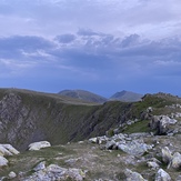

Swirl how June 2021
Swirl How
Swirl how