– Lat/Long: 38.93° N 42.83° E
 Suphan Dagi
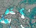
Weather Forecast, TurkeyIssued: 2 pm Mon 03 Aug Local TimeUpdates in: hr min sUpdate imminent
Issued: 2 pm Mon 03 Aug Local Time
Updates in:
Update imminent hr min s

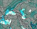
Issued: 2 pm Mon 03 Aug Local Time
Updates in:
Update imminent hr min s
Days 1–4 Weather SummaryMostly dry. Very mild (max 17°C on Mon afternoon, min 12°C on Wed night). Winds increasing (calm on Mon night, fresh winds from the SSW by Tue night). | Days 5–7 Weather SummaryMostly dry. Very mild (max 16°C on Fri afternoon, min 12°C on Thu night). Wind will be generally light. | ||||||||||||||||
Mon 3 | Tuesday 4 | Wednesday 5 | Thursday 6 | Friday 7 | Saturday 8 | ||||||||||||
PM | night | AM | PM | night | AM | PM | night | AM | PM | night | AM | PM | night | AM | PM | night | |
some clouds | clear | clear | clear | clear | clear | clear | clear | clear | some clouds | clear | clear | clear | clear | clear | clear | clear | |
Cloud base (m) | 5600 | 5350 | 5700 | 5350 | |||||||||||||
km/h | |||||||||||||||||
 |  |  |  |  |  | ||||||||||||
— | — | — | — | — | — | — | — | — | — | — | — | — | — | — | — | — | |
mm | — | — | — | — | — | — | — | — | — | — | — | — | — | — | — | — | — |
max °C | 17 | 15 | 15 | 17 | 15 | 14 | 16 | 14 | 13 | 15 | 14 | 13 | 16 | 15 | 14 | 16 | 15 |
min °C | 16 | 14 | 14 | 16 | 13 | 13 | 15 | 12 | 12 | 15 | 12 | 12 | 15 | 13 | 13 | 16 | 13 |
chill °C | 16 | 13 | 13 | 14 | 12 | 12 | 13 | 10 | 10 | 14 | 12 | 11 | 14 | 12 | 12 | 16 | 12 |
Freezing level m | 5700 | 5650 | 5600 | 5700 | 5700 | 5700 | 5950 | 5800 | 5600 | 5800 | 5650 | 5550 | 5850 | 5800 | 5650 | 5850 | 5700 |
— | — | 5:11 | — | — | 5:11 | — | — | 5:13 | — | — | 5:13 | — | — | 5:15 | — | — | |
7:17 | — | — | 7:16 | — | — | 7:15 | — | — | 7:14 | — | — | 7:13 | — | — | 7:12 | — | |
Loading...
Suphan Dagi Weather (Days 0-3):
The weather forecast for Suphan Dagi is: Mostly dry. Very mild (max 17°C on Mon afternoon, min 12°C on Wed night). Winds increasing (calm on Mon night, fresh winds from the SSW by Tue night).
Suphan Dagi Weather (Days 3-6):
Mostly dry. Very mild (max 16°C on Fri afternoon, min 12°C on Thu night). Wind will be generally light.
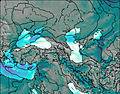
This table gives the weather forecast for Suphan Dagi at the specific elevation of 3500 m. Our advanced weather models allow us to provide distinct weather forecasts for several elevations of Suphan Dagi. To see the weather forecasts for the other elevations, use the tab navigation above the table. For a wider overview of the weather, consult the Weather Map of Turkey.
| Weather Station | Temp. | Weather | Wind | Gusts | Cloud / Visibility |
|---|---|---|---|---|---|
Va / eritmelen | |||||
Bitlis Merkez | |||||
Şirnak |
* NOTE: not all weather observatories update at the same frequency which is the reason why some locations may show data from stations that are further away than known closer ones.
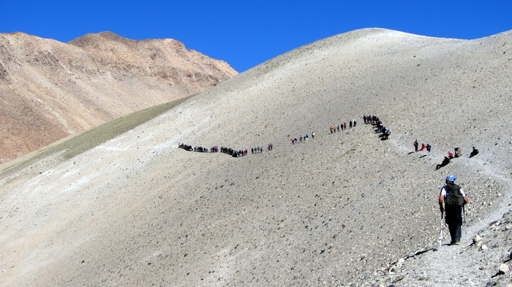
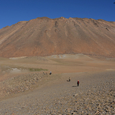
Suphan Dagi Photos
View all
Southeastern Anatolia photos (134) |
Anatolia photos (529) |
photos from mountains in Turkey (496) |
all photos
 Upload new photo
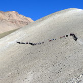
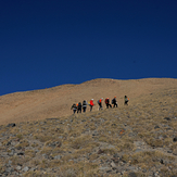


 See 23 more Suphan Dagi photos
Süphan Zirve Tırmanışı
ERKAN PINAR
Süphan Dağından Ağrı Görünümü
Zirve
Tur kayagi
Süphan Dağı zirve