– Lat/Long: 55.84° N 3.29° W
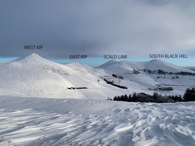
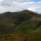
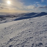
 Scald Law
Weather Forecast, United KingdomIssued: 12 pm Mon 03 Aug Local TimeUpdates in: hr min sUpdate imminent
Issued: 12 pm Mon 03 Aug Local Time
Updates in:
Update imminent hr min s

Issued: 12 pm Mon 03 Aug Local Time
Updates in:
Update imminent hr min s
Days 1–3 Weather SummaryHeavy rain (total 25mm), heaviest during Mon night. Very mild (max 18°C on Tue afternoon, min 11°C on Wed night). Wind will be generally light. | Days 4–6 Weather SummarySome drizzle, heaviest during Thu morning. Very mild (max 18°C on Fri afternoon, min 10°C on Thu night). Wind will be generally light. | |||||||||||||||||
Monday 3 | Tuesday 4 | Wednesday 5 | Thursday 6 | Friday 7 | Saturday 8 | |||||||||||||
AM | PM | night | AM | PM | night | AM | PM | night | AM | PM | night | AM | PM | night | AM | PM | night | |
light rain | rain shwrs | heavy rain | light rain | rain shwrs | rain shwrs | light rain | rain shwrs | light rain | rain shwrs | rain shwrs | some clouds | some clouds | some clouds | cloudy | light rain | rain shwrs | clear | |
Cloud base (m) | 300 | 1600 | 650 | 350 | 300 | 550 | 250 | 400 | 400 | 800 | 1600 | 400 | 1000 | 5450 | 750 | 450 | 2250 | |
km/h | ||||||||||||||||||
 |  |  |  |  |  | |||||||||||||
— | — | — | — | — | — | — | — | — | — | — | — | — | — | — | — | — | — | |
mm | 2 | 0.3 | 14 | 3 | 1.3 | 0.5 | 0.4 | 0.4 | 4 | 0.7 | 0.1 | — | — | — | — | 0.1 | 0.5 | — |
max °C | 13 | 17 | 14 | 16 | 18 | 15 | 15 | 16 | 14 | 16 | 17 | 12 | 17 | 18 | 14 | 15 | 16 | 13 |
min °C | 13 | 15 | 14 | 15 | 18 | 15 | 14 | 16 | 11 | 14 | 15 | 10 | 14 | 17 | 13 | 14 | 15 | 11 |
chill °C | 13 | 14 | 13 | 14 | 18 | 15 | 13 | 15 | 11 | 14 | 14 | 8 | 12 | 16 | 12 | 12 | 13 | 9 |
Freezing level m | 2650 | 2850 | 3150 | 3300 | 3300 | 3150 | 2550 | 2850 | 2600 | 2200 | 2400 | 2500 | 2350 | 2400 | 2650 | 2900 | 3350 | 3000 |
5:20 | — | — | 5:22 | — | — | 5:24 | — | — | 5:26 | — | — | 5:28 | — | — | 5:28 | — | — | |
— | 9:15 | — | — | 9:14 | — | — | 9:12 | — | — | 9:09 | — | — | 9:07 | — | — | 9:06 | — | |
Loading...
Scald Law Weather (Days 0-3):
The weather forecast for Scald Law is: Heavy rain (total 25mm), heaviest during Mon night. Very mild (max 18°C on Tue afternoon, min 11°C on Wed night). Wind will be generally light.
Scald Law Weather (Days 3-6):
Some drizzle, heaviest during Thu morning. Very mild (max 18°C on Fri afternoon, min 10°C on Thu night). Wind will be generally light.
This table gives the weather forecast for Scald Law at the specific elevation of 113 m. Our advanced weather models allow us to provide distinct weather forecasts for several elevations of Scald Law. To see the weather forecasts for the other elevations, use the tab navigation above the table. For a wider overview of the weather, consult the Weather Map of United Kingdom.
| Weather Station | Temp. | Weather | Wind | Gusts | Cloud / Visibility |
|---|---|---|---|---|---|
Edinburgh Airport | |||||
Broughton | |||||
SHIP5111 | |||||
SHIP8222 |
* NOTE: not all weather observatories update at the same frequency which is the reason why some locations may show data from stations that are further away than known closer ones.
Scald Law Photos
View all
Pentland Hills photos (2) |
Scottish Lowlands photos (31) |
photos from mountains in United Kingdom (2125) |
all photos
 Upload new photo
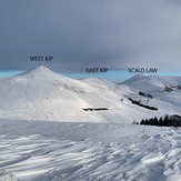
The Pentlands In Winter
Scald Law
Carnethy wander