– Lat/Long: 47.25° N 9.34° E
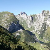
 Säntis (Santis)
Weather Forecast, SwitzerlandIssued: 1 pm Mon 03 Aug Local TimeUpdates in: hr min sUpdate imminent
Issued: 1 pm Mon 03 Aug Local Time
Updates in:
Update imminent hr min s

Issued: 1 pm Mon 03 Aug Local Time
Updates in:
Update imminent hr min s
Days 1–4 Weather SummaryLight rain (total 9mm), mostly falling on Tue night. Very mild (max 16°C on Mon afternoon, min 11°C on Tue night). Wind will be generally light. | Days 5–7 Weather SummaryHeavy rain (total 48mm), heaviest during Thu night. Very mild (max 12°C on Thu afternoon, min 7°C on Fri morning). Wind will be generally light. | ||||||||||||||||
Mon 3 | Tuesday 4 | Wednesday 5 | Thursday 6 | Friday 7 | Saturday 8 | ||||||||||||
PM | night | AM | PM | night | AM | PM | night | AM | PM | night | AM | PM | night | AM | PM | night | |
some clouds | risk tstorm | clear | clear | rain shwrs | clear | some clouds | risk tstorm | rain shwrs | risk tstorm | rain shwrs | rain shwrs | risk tstorm | clear | clear | some clouds | clear | |
Cloud base (m) | 3950 | 5200 | 4700 | 4400 | 2850 | 2700 | 2000 | 850 | 1700 | 2200 | 9150 | 9600 | 2450 | ||||
km/h | |||||||||||||||||
 |  |  |  |  |  | ||||||||||||
— | — | — | — | — | — | — | — | — | — | — | — | — | — | — | — | — | |
mm | — | 0.1 | — | — | 5 | — | — | 3 | 0.5 | 10 | 37 | 0.5 | 0.9 | — | — | — | — |
max °C | 16 | 14 | 14 | 15 | 15 | 12 | 13 | 12 | 12 | 12 | 8 | 8 | 9 | 9 | 9 | 11 | 12 |
min °C | 15 | 13 | 13 | 15 | 11 | 11 | 12 | 12 | 11 | 11 | 8 | 7 | 9 | 9 | 9 | 10 | 11 |
chill °C | 14 | 12 | 12 | 14 | 10 | 10 | 12 | 11 | 11 | 10 | 5 | 7 | 9 | 9 | 8 | 10 | 9 |
Freezing level m | 4550 | 4600 | 4450 | 4600 | 4350 | 4350 | 4350 | 4250 | 4200 | 4300 | 3850 | 3850 | 4000 | 4050 | 4050 | 4100 | 4350 |
— | — | 6:03 | — | — | 6:05 | — | — | 6:05 | — | — | 6:07 | — | — | 6:09 | — | — | |
— | 8:53 | — | — | 8:52 | — | — | 8:51 | — | — | 8:49 | — | — | 8:47 | — | — | 8:45 | |
Loading...
Säntis Weather (Days 0-3):
The weather forecast for Säntis is: Light rain (total 9mm), mostly falling on Tue night. Very mild (max 16°C on Mon afternoon, min 11°C on Tue night). Wind will be generally light.
Säntis Weather (Days 3-6):
Heavy rain (total 48mm), heaviest during Thu night. Very mild (max 12°C on Thu afternoon, min 7°C on Fri morning). Wind will be generally light.
This table gives the weather forecast for Säntis at the specific elevation of 2502 m. Our advanced weather models allow us to provide distinct weather forecasts for several elevations of Säntis. To see the weather forecasts for the other elevations, use the tab navigation above the table. For a wider overview of the weather, consult the Weather Map of Switzerland.
| Weather Station | Temp. | Weather | Wind | Gusts | Cloud / Visibility |
|---|---|---|---|---|---|
Stockberg | |||||
Urnäsch | |||||
Studnerberg | |||||
Grabs Landeplatz | |||||
thunderstorm affecting Krummenau | |||||
Flums Landeplatz | |||||
Prodkamm | |||||
Bargella | |||||
Schönhalden |
* NOTE: not all weather observatories update at the same frequency which is the reason why some locations may show data from stations that are further away than known closer ones.
Säntis Photos
View all
Glarus Alps photos (60) |
Alps photos (1485) |
photos from mountains in Switzerland (649) |
all photos
 Upload new photo
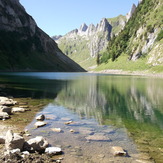
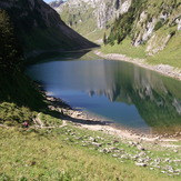
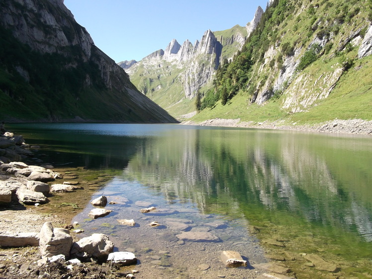
Falensse
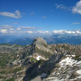
Altmann nearby Säntis
Säntis 2503 m, Peak top right
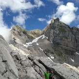
Altmann
Falensse