– Lat/Long: 59.95° N 7.14° E
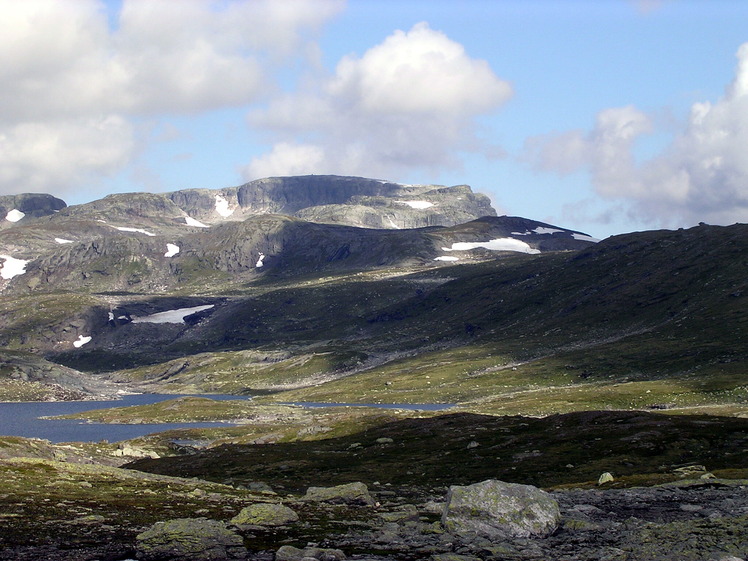
 Sandfloegga
Weather Forecast, NorwayIssued: 1 pm Mon 03 Aug Local TimeUpdates in: hr min sUpdate imminent
Issued: 1 pm Mon 03 Aug Local Time
Updates in:
Update imminent hr min s

Issued: 1 pm Mon 03 Aug Local Time
Updates in:
Update imminent hr min s
Days 1–4 Weather SummaryHeavy rain (total 23mm), heaviest during Wed night. Mild temperatures (max 9°C on Wed afternoon, min 3°C on Mon afternoon). Wind will be generally light. | Days 5–7 Weather SummaryModerate rain (total 10mm) heaviest on Thu night, then becoming colder with a dusting of snow on Sun morning. Mild temperatures (max 6°C on Thu afternoon, min 1°C on Fri night). Winds increasing (light winds from the NW on Thu night, fresh winds from the W by Sun morning). | ||||||||||||||||
Mon 3 | Tuesday 4 | Wednesday 5 | Thursday 6 | Friday 7 | Saturday 8 | ||||||||||||
PM | night | AM | PM | night | AM | PM | night | AM | PM | night | AM | PM | night | AM | PM | night | |
rain shwrs | some clouds | cloudy | light rain | mod. rain | light rain | rain shwrs | rain shwrs | rain shwrs | rain shwrs | light rain | rain shwrs | rain shwrs | some clouds | some clouds | light rain | light rain | |
Cloud base (m) | 2000 | 6000 | 4300 | 2300 | 800 | 800 | 850 | 1550 | 1400 | 850 | 850 | 900 | 2200 | 5300 | 2150 | 1800 | 800 |
km/h | |||||||||||||||||
 |  |  |  |  |  | ||||||||||||
— | — | — | — | — | — | — | — | — | — | — | — | — | — | — | — | — | |
mm | 0.1 | — | — | 1.4 | 9 | 0.4 | 1 | 8 | 3 | 0.4 | 4 | 0.3 | 0.1 | — | — | 0.3 | 5 |
max °C | 4 | 4 | 6 | 8 | 6 | 7 | 9 | 9 | 5 | 6 | 6 | 4 | 5 | 4 | 3 | 4 | 3 |
min °C | 3 | 3 | 3 | 6 | 5 | 6 | 9 | 5 | 4 | 6 | 4 | 4 | 5 | 1 | 1 | 4 | 2 |
chill °C | -1 | 0 | 3 | 3 | 2 | 4 | 7 | 3 | 1 | 3 | 2 | 2 | 2 | -2 | -2 | -1 | -4 |
Freezing level m | 2450 | 2450 | 2950 | 2950 | 3200 | 3100 | 3300 | 2700 | 2650 | 2650 | 2600 | 2500 | 2550 | 2000 | 2300 | 2350 | 2200 |
— | — | 5:18 | — | — | 5:20 | — | — | 5:22 | — | — | 5:24 | — | — | 5:26 | — | — | |
— | 9:57 | — | — | 9:54 | — | — | 9:52 | — | — | 9:50 | — | — | 9:46 | — | — | 9:45 | |
Loading...
Sandfloegga Weather (Days 0-3):
The weather forecast for Sandfloegga is: Heavy rain (total 23mm), heaviest during Wed night. Mild temperatures (max 9°C on Wed afternoon, min 3°C on Mon afternoon). Wind will be generally light.
Sandfloegga Weather (Days 3-6):
Moderate rain (total 10mm) heaviest on Thu night, then becoming colder with a dusting of snow on Sun morning. Mild temperatures (max 6°C on Thu afternoon, min 1°C on Fri night). Winds increasing (light winds from the NW on Thu night, fresh winds from the W by Sun morning).
This table gives the weather forecast for Sandfloegga at the specific elevation of 1721 m. Our advanced weather models allow us to provide distinct weather forecasts for several elevations of Sandfloegga. To see the weather forecasts for the other elevations, use the tab navigation above the table. For a wider overview of the weather, consult the Weather Map of Norway.
Sandfloegga Photos
View all
Scandinavia/European Arctic Ranges photos (16) |
photos from mountains in Norway (115) |
all photos
 Upload new photo
Sandfloegga