– Lat/Long: 38.99° N 120.13° W
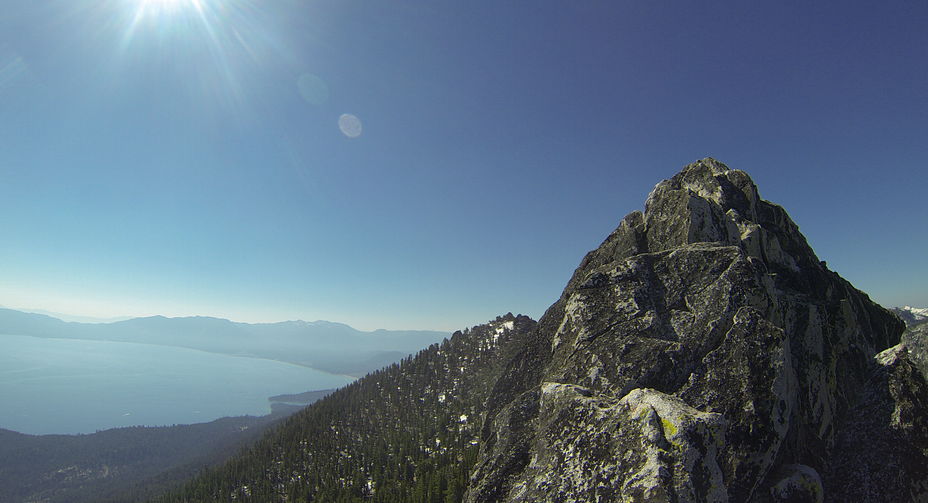
 Rubicon Peak
Weather Forecast, United StatesIssued: 10 pm Sun 02 Aug Local TimeUpdates in: hr min sUpdate imminent
Issued: 10 pm Sun 02 Aug Local Time
Updates in:
Update imminent hr min s

Issued: 10 pm Sun 02 Aug Local Time
Updates in:
Update imminent hr min s
Days 1–4 Weather SummaryMostly dry. Warm (max 27°C on Tue afternoon, min 17°C on Sun night). Wind will be generally light. | Days 5–7 Weather SummaryMostly dry. Warm (max 28°C on Fri afternoon, min 19°C on Wed night). Mainly fresh winds. | ||||||||||||||||||
Monday 3 | Tuesday 4 | Wednesday 5 | Thursday 6 | Friday 7 | Saturday 8 | ||||||||||||||
night | AM | PM | night | AM | PM | night | AM | PM | night | AM | PM | night | AM | PM | night | AM | PM | night | |
clear | clear | clear | clear | clear | clear | clear | clear | clear | clear | clear | clear | clear | clear | clear | clear | clear | clear | clear | |
Cloud base (m) | 9100 | ||||||||||||||||||
km/h | |||||||||||||||||||
 |  |  |  |  |  |  | |||||||||||||
— | — | — | — | — | — | — | — | — | — | — | — | — | — | — | — | — | — | — | |
mm | — | — | — | — | — | — | — | — | — | — | — | — | — | — | — | — | — | — | — |
max °C | 20 | 24 | 26 | 22 | 25 | 27 | 22 | 26 | 27 | 22 | 26 | 27 | 22 | 26 | 28 | 23 | 26 | 27 | 22 |
min °C | 17 | 20 | 26 | 19 | 21 | 26 | 20 | 22 | 26 | 19 | 22 | 26 | 20 | 23 | 26 | 20 | 23 | 26 | 20 |
chill °C | 17 | 20 | 26 | 19 | 21 | 26 | 20 | 22 | 26 | 19 | 22 | 26 | 20 | 23 | 26 | 20 | 23 | 26 | 20 |
Freezing level m | 5300 | 5250 | 5450 | 5300 | 5300 | 5400 | 5400 | 5300 | 5350 | 5300 | 5250 | 5400 | 5400 | 5400 | 5400 | 5450 | 5350 | 5400 | 5350 |
— | 6:01 | — | — | 6:03 | — | — | 6:03 | — | — | 6:05 | — | — | 6:05 | — | — | 6:07 | — | — | |
— | — | — | 8:09 | — | — | 8:08 | — | — | 8:07 | — | — | 8:06 | — | — | 8:05 | — | — | 8:04 | |
Loading...
Rubicon Peak Weather (Days 0-3):
The weather forecast for Rubicon Peak is: Mostly dry. Warm (max 27°C on Tue afternoon, min 17°C on Sun night). Wind will be generally light.
Rubicon Peak Weather (Days 3-6):
Mostly dry. Warm (max 28°C on Fri afternoon, min 19°C on Wed night). Mainly fresh winds.
This table gives the weather forecast for Rubicon Peak at the specific elevation of 2000 m. Our advanced weather models allow us to provide distinct weather forecasts for several elevations of Rubicon Peak. To see the weather forecasts for the other elevations, use the tab navigation above the table. For a wider overview of the weather, consult the Weather Map of California.
| Weather Station | Temp. | Weather | Wind | Gusts | Cloud / Visibility |
|---|---|---|---|---|---|
South Lake Tahoe Airport | |||||
Truckee Tahoe Airport | |||||
Carson City Airport | |||||
Emigrant Gap Airport | |||||
Placerville Airport (California) | |||||
Reno Airport | |||||
Reno Stead Airport | |||||
Nevada County Air Park -Grass Valley (California) |
* NOTE: not all weather observatories update at the same frequency which is the reason why some locations may show data from stations that are further away than known closer ones.
Rubicon Peak Photos
View all
Carson Range photos (32) |
Sierra Nevada photos (212) |
photos from mountains in United States (3056) |
all photos
 Upload new photo
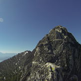
Summit Block
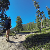
Rubicon Peak Trailhead