– Lat/Long: 44.70° S 169.07° E
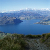
 Roys Peak
Weather Forecast, New ZealandIssued: 11 pm Mon 03 Aug Local TimeUpdates in: hr min sUpdate imminent
Issued: 11 pm Mon 03 Aug Local Time
Updates in:
Update imminent hr min s

Issued: 11 pm Mon 03 Aug Local Time
Updates in:
Update imminent hr min s
Days 1–4 Weather SummaryMostly dry. Freeze-thaw conditions (max 3°C on Thu afternoon, min -5°C on Tue morning). Wind will be generally light. | Days 5–7 Weather SummaryA dusting of new snow. Temperatures will be slightly above freezing (max 4°C on Sat morning, min 1°C on Thu night). Wind will be generally light. | ||||||||||||||||||
Tuesday 4 | Wednesday 5 | Thursday 6 | Friday 7 | Saturday 8 | Sunday 9 | ||||||||||||||
night | AM | PM | night | AM | PM | night | AM | PM | night | AM | PM | night | AM | PM | night | AM | PM | night | |
clear | clear | clear | clear | clear | some clouds | clear | clear | some clouds | some clouds | light snow | light rain | some clouds | some clouds | some clouds | some clouds | some clouds | clear | clear | |
Cloud base (m) | 700 | 950 | 950 | 700 | 7250 | 8750 | 2450 | 600 | 750 | 1800 | 2850 | 1500 | 1700 | 950 | 1500 | ||||
km/h | |||||||||||||||||||
 |  |  |  |  |  |  | |||||||||||||
— | — | — | — | — | — | — | — | — | — | 1 | — | — | — | — | — | — | — | — | |
mm | — | — | — | — | — | — | — | — | — | — | — | 0.3 | — | — | — | — | — | — | — |
max °C | 0 | -4 | -3 | -2 | 2 | 2 | 0 | 2 | 3 | 1 | 2 | 2 | 3 | 4 | 4 | 3 | 3 | 4 | 2 |
min °C | -4 | -5 | -4 | -4 | -1 | 1 | -1 | 0 | 1 | 1 | 2 | 2 | 3 | 3 | 3 | 2 | 2 | 3 | 2 |
chill °C | -9 | -9 | -7 | -4 | -1 | 1 | -1 | 0 | -1 | -2 | -1 | -1 | 1 | 3 | 3 | 2 | 2 | 3 | 2 |
Freezing level m | 500 | 300 | 600 | 0 | 0 | 1400 | 600 | 0 | 1450 | 1200 | 1400 | 1450 | 1500 | 1650 | 1600 | 1500 | 1500 | 1550 | 1550 |
— | 7:56 | — | — | 7:56 | — | — | 7:54 | — | — | 7:52 | — | — | 7:52 | — | — | 7:50 | — | — | |
— | — | 5:42 | — | — | 5:44 | — | — | 5:45 | — | — | 5:45 | — | — | 5:46 | — | — | 5:47 | — | |
Loading...
Roys Peak Weather (Days 0-3):
The weather forecast for Roys Peak is: Mostly dry. Freeze-thaw conditions (max 3°C on Thu afternoon, min -5°C on Tue morning). Wind will be generally light.
Roys Peak Weather (Days 3-6):
A dusting of new snow. Temperatures will be slightly above freezing (max 4°C on Sat morning, min 1°C on Thu night). Wind will be generally light.
This table gives the weather forecast for Roys Peak at the specific elevation of 1000 m. Our advanced weather models allow us to provide distinct weather forecasts for several elevations of Roys Peak. To see the weather forecasts for the other elevations, use the tab navigation above the table. For a wider overview of the weather, consult the Weather Map of New Zealand.
Roys Peak Photos
View all
Southern Alps photos (37) |
New Zealand photos (156) |
photos from mountains in New Zealand (160) |
all photos
 Upload new photo
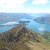
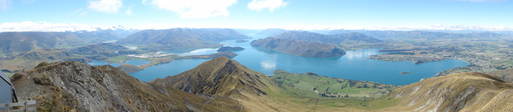
Roys Peak - Wanaka NZ - Summit Panorama
Roys Peak As Viewed From A Light Aircraft
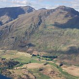
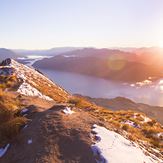
Roys Peak
Roys Peak