– Lat/Long: 48.84° N 0.38° W
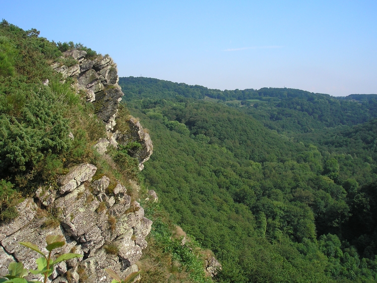
 Rock of Oëtre (Rock of Oetre)
Weather Forecast, FranceIssued: 7 am Mon 03 Aug Local TimeUpdates in: hr min sUpdate imminent
Issued: 7 am Mon 03 Aug Local Time
Updates in:
Update imminent hr min s

Issued: 7 am Mon 03 Aug Local Time
Updates in:
Update imminent hr min s
Days 1–3 Weather SummaryMostly dry. Warm (max 34°C on Mon afternoon, min 11°C on Wed night). Wind will be generally light. | Days 4–6 Weather SummaryMostly dry. Warm (max 26°C on Sat afternoon, min 11°C on Thu night). Wind will be generally light. | |||||||||||||||||
Monday 3 | Tuesday 4 | Wednesday 5 | Thursday 6 | Friday 7 | Saturday 8 | |||||||||||||
AM | PM | night | AM | PM | night | AM | PM | night | AM | PM | night | AM | PM | night | AM | PM | night | |
some clouds | rain shwrs | clear | some clouds | some clouds | clear | some clouds | clear | clear | clear | clear | clear | some clouds | clear | some clouds | some clouds | some clouds | clear | |
Cloud base (m) | 5800 | 4500 | 4450 | 1700 | 2050 | 300 | 6900 | 9050 | 8900 | 6750 | 6250 | 3200 | ||||||
km/h | ||||||||||||||||||
 |  |  |  |  |  | |||||||||||||
— | — | — | — | — | — | — | — | — | — | — | — | — | — | — | — | — | — | |
mm | — | 0.1 | — | — | — | — | — | — | — | — | — | — | — | — | — | — | — | — |
max °C | 28 | 34 | 29 | 24 | 30 | 28 | 19 | 24 | 22 | 18 | 22 | 20 | 19 | 25 | 21 | 21 | 26 | 22 |
min °C | 21 | 32 | 18 | 17 | 28 | 15 | 15 | 23 | 11 | 12 | 21 | 11 | 12 | 24 | 13 | 14 | 26 | 14 |
chill °C | 21 | 32 | 18 | 17 | 28 | 14 | 14 | 23 | 10 | 12 | 21 | 11 | 12 | 24 | 12 | 14 | 26 | 14 |
Freezing level m | 4100 | 3900 | 4150 | 4050 | 3650 | 4150 | 4000 | 3800 | 3550 | 3350 | 3500 | 3600 | 3550 | 3650 | 3600 | 3550 | 3400 | 3450 |
6:35 | — | — | 6:37 | — | — | 6:39 | — | — | 6:39 | — | — | 6:41 | — | — | 6:43 | — | — | |
— | — | 9:37 | — | — | 9:36 | — | — | 9:34 | — | — | 9:32 | — | — | 9:30 | — | — | 9:30 | |
Loading...
Rock of Oëtre Weather (Days 0-3):
The weather forecast for Rock of Oëtre is: Mostly dry. Warm (max 34°C on Mon afternoon, min 11°C on Wed night). Wind will be generally light.
Rock of Oëtre Weather (Days 3-6):
Mostly dry. Warm (max 26°C on Sat afternoon, min 11°C on Thu night). Wind will be generally light.
This table gives the weather forecast for Rock of Oëtre at the specific elevation of 118 m. Our advanced weather models allow us to provide distinct weather forecasts for several elevations of Rock of Oëtre. To see the weather forecasts for the other elevations, use the tab navigation above the table. For a wider overview of the weather, consult the Weather Map of France.
| Weather Station | Temp. | Weather | Wind | Gusts | Cloud / Visibility |
|---|---|---|---|---|---|
Granville | |||||
Langrune sur Mer | |||||
ST Gatien Des B | |||||
St Gatien Airport | |||||
LE Havre Octeville | |||||
Ass Nautique Hautais |
* NOTE: not all weather observatories update at the same frequency which is the reason why some locations may show data from stations that are further away than known closer ones.
Rock of Oëtre Photos
View all
Minor ranges of Europe photos (96) |
photos from mountains in France (302) |
all photos
 Upload new photo
Rock of Oëtre