
– Lat/Long: 37.18° N 80.16° W
 Poor Mountain
Weather Forecast, United StatesIssued: 7 am Mon 03 Aug Local TimeUpdates in: hr min sUpdate imminent
Issued: 7 am Mon 03 Aug Local Time
Updates in:
Update imminent hr min s

Issued: 7 am Mon 03 Aug Local Time
Updates in:
Update imminent hr min s
Days 1–3 Weather SummaryLight rain (total 9mm), mostly falling on Tue afternoon. Warm (max 21°C on Mon afternoon, min 18°C on Mon morning). Winds increasing (calm on Mon afternoon, fresh winds from the SW by Wed night). | Days 4–6 Weather SummaryHeavy rain (total 21mm), heaviest during Fri night. Warm (max 24°C on Thu afternoon, min 19°C on Thu morning). Winds decreasing (fresh winds from the SW on Thu morning, light winds from the WNW by Sat morning). | |||||||||||||||||
Monday 3 | Tuesday 4 | Wednesday 5 | Thursday 6 | Friday 7 | Saturday 8 | |||||||||||||
AM | PM | night | AM | PM | night | AM | PM | night | AM | PM | night | AM | PM | night | AM | PM | night | |
clear | risk tstorm | risk tstorm | some clouds | risk tstorm | light rain | rain shwrs | risk tstorm | risk tstorm | clear | some clouds | risk tstorm | rain shwrs | risk tstorm | rain shwrs | clear | rain shwrs | rain shwrs | |
Cloud base (m) | 2200 | 9350 | 750 | 850 | 600 | 550 | 1850 | 2200 | 6000 | 5100 | 2700 | 4350 | 4950 | 2700 | ||||
km/h | ||||||||||||||||||
 |  |  |  |  |  | |||||||||||||
— | — | — | — | — | — | — | — | — | — | — | — | — | — | — | — | — | — | |
mm | — | 1.3 | 1.2 | — | 3 | 1.2 | 0.4 | 1.7 | 0.9 | — | — | 1.2 | 0.4 | 0.3 | 10 | — | 0.2 | 9 |
max °C | 19 | 21 | 21 | 18 | 19 | 18 | 18 | 21 | 20 | 21 | 24 | 22 | 22 | 24 | 21 | 22 | 24 | 21 |
min °C | 18 | 21 | 18 | 18 | 19 | 18 | 18 | 20 | 19 | 19 | 24 | 20 | 20 | 24 | 20 | 20 | 24 | 20 |
chill °C | 18 | 21 | 18 | 17 | 19 | 17 | 18 | 20 | 18 | 18 | 24 | 20 | 20 | 24 | 20 | 20 | 24 | 20 |
Freezing level m | 4550 | 4450 | 4500 | 4700 | 4700 | 4750 | 4800 | 4800 | 4800 | 4650 | 4650 | 4800 | 4600 | 4550 | 4600 | 4600 | 4600 | 4700 |
6:26 | — | — | 6:26 | — | — | 6:28 | — | — | 6:28 | — | — | 6:30 | — | — | 6:30 | — | — | |
— | — | 8:25 | — | — | 8:24 | — | — | 8:23 | — | — | 8:22 | — | — | 8:22 | — | — | 8:21 | |
Loading...
Poor Mountain Weather (Days 0-3):
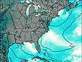
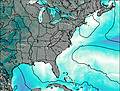
The weather forecast for Poor Mountain is: Light rain (total 9mm), mostly falling on Tue afternoon. Warm (max 21°C on Mon afternoon, min 18°C on Mon morning). Winds increasing (calm on Mon afternoon, fresh winds from the SW by Wed night).
Poor Mountain Weather (Days 3-6):
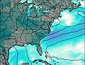
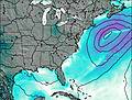
Heavy rain (total 21mm), heaviest during Fri night. Warm (max 24°C on Thu afternoon, min 19°C on Thu morning). Winds decreasing (fresh winds from the SW on Thu morning, light winds from the WNW by Sat morning).
This table gives the weather forecast for Poor Mountain at the specific elevation of 1197 m. Our advanced weather models allow us to provide distinct weather forecasts for several elevations of Poor Mountain. To see the weather forecasts for the other elevations, use the tab navigation above the table. For a wider overview of the weather, consult the Weather Map of Virginia.
| Weather Station | Temp. | Weather | Wind | Gusts | Cloud / Visibility |
|---|---|---|---|---|---|
Roanoke Airport | |||||
Blacksbur / irginia Tech Montgomery Executive Airport | |||||
Dubli / ew River Valley Airport | |||||
Martinsville Airport | |||||
Lewisbur / reenbrier Valley Airport | |||||
Mount Air / urry Airport | |||||
Rockingham County North Carolina Shiloh - Reidsville Airport | |||||
Lynchburg Airport |
* NOTE: not all weather observatories update at the same frequency which is the reason why some locations may show data from stations that are further away than known closer ones.