– Lat/Long: 45.87° N 6.99° E
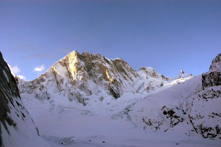
 Pointe Walker
Weather Forecast, FranceIssued: 7 pm Thu 16 Jul Local TimeUpdates in: hr min sUpdate imminent
Issued: 7 pm Thu 16 Jul Local Time
Updates in:
Update imminent hr min s

Issued: 7 pm Thu 16 Jul Local Time
Updates in:
Update imminent hr min s
Days 1–4 Weather SummaryHeavy rain (total 33mm), heaviest during Thu night. Very mild (max 10°C on Thu night, min 3°C on Thu night). Wind will be generally light. | Days 5–7 Weather SummaryMostly dry. Mild temperatures (max 7°C on Mon afternoon, min 2°C on Tue morning). Wind will be generally light. | ||||||||||||||||||
Friday 17 | Saturday 18 | Sunday 19 | Monday 20 | Tuesday 21 | Wednesday 22 | ||||||||||||||
night | AM | PM | night | AM | PM | night | AM | PM | night | AM | PM | night | AM | PM | night | AM | PM | night | |
rain shwrs | rain shwrs | clear | risk tstorm | clear | clear | rain shwrs | rain shwrs | rain shwrs | rain shwrs | clear | clear | risk tstorm | clear | clear | clear | clear | clear | rain shwrs | |
km/h | |||||||||||||||||||
 |  |  |  |  |  |  | |||||||||||||
— | — | — | — | — | — | — | — | — | — | — | — | — | — | — | — | — | — | — | |
mm | 17 | 10 | — | 5 | — | — | 0.1 | 0.1 | 0.7 | 0.1 | — | — | 0.6 | — | — | — | — | — | 0.3 |
max °C | 10 | 8 | 10 | 9 | 6 | 8 | 6 | 5 | 6 | 6 | 6 | 7 | 6 | 2 | 4 | 5 | 5 | 7 | 6 |
min °C | 3 | 5 | 10 | 6 | 6 | 7 | 5 | 5 | 6 | 6 | 6 | 7 | 3 | 2 | 4 | 3 | 4 | 6 | 4 |
chill °C | 0 | 2 | 8 | 3 | 3 | 4 | 2 | 2 | 3 | 4 | 3 | 4 | 0 | -1 | 2 | 3 | 2 | 4 | 1 |
Freezing level m | 4050 | 4150 | 4400 | 4100 | 3850 | 4050 | 3900 | 3750 | 3850 | 3950 | 3750 | 3900 | 3650 | 3250 | 3600 | 3750 | 3650 | 3950 | 3650 |
Cloud base (m) | 7450 | 4500 | 3950 | 9100 | 3450 | 4300 | |||||||||||||
— | 5:56 | — | — | 5:58 | — | — | 5:58 | — | — | 6:00 | — | — | 6:01 | — | — | 6:01 | — | — | |
— | — | — | 9:16 | — | — | 9:16 | — | — | 9:15 | — | — | 9:15 | — | — | 9:14 | — | — | 9:13 | |
Loading...
Pointe Walker Weather (Days 0-3):
The weather forecast for Pointe Walker is: Heavy rain (total 33mm), heaviest during Thu night. Very mild (max 10°C on Thu night, min 3°C on Thu night). Wind will be generally light.
Pointe Walker Weather (Days 3-6):
Mostly dry. Mild temperatures (max 7°C on Mon afternoon, min 2°C on Tue morning). Wind will be generally light.
This table gives the weather forecast for Pointe Walker at the specific elevation of 3000 m. Our advanced weather models allow us to provide distinct weather forecasts for several elevations of Pointe Walker. To see the weather forecasts for the other elevations, use the tab navigation above the table. For a wider overview of the weather, consult the Weather Map of France.
| Weather Station | Temp. | Weather | Wind | Gusts | Cloud / Visibility |
|---|---|---|---|---|---|
lightning 5km SE of Chamonix-Mont-Blanc | |||||
lightning 4km SE of Courmayeur | |||||
thunderstorm affecting Morgex | |||||
Col DU Grand ST -Bernard | |||||
lightning 5km E of Les Contamines-Montjoie | |||||
lightning 8km SE of Orsieres | |||||
thunderstorm affecting Les Houches | |||||
lightning 4km NNE of Saint-Gervais-les-Bains | |||||
Som la Proz | |||||
lightning 5km NNW of Saint-Pierre |
* NOTE: not all weather observatories update at the same frequency which is the reason why some locations may show data from stations that are further away than known closer ones.
Pointe Walker Photos
View all
Savoy Alps photos (140) |
Alps photos (1484) |
photos from mountains in France (301) |
all photos
 Upload new photo
Pointe Walker