
– Lat/Long: 8.80° N 70.98° W
 Pico Pan de Azúcar (Pico Pan de Azucar)
Weather Forecast, VenezuelaIssued: 7 am Wed 15 Jul Local TimeUpdates in: hr min sUpdate imminent
Issued: 7 am Wed 15 Jul Local Time
Updates in:
Update imminent hr min s

Issued: 7 am Wed 15 Jul Local Time
Updates in:
Update imminent hr min s
Days 1–3 Weather SummaryLight rain (total 4mm) at first, then becoming colder with a dusting of snow on Wed night. Freeze-thaw conditions (max 4°C on Thu afternoon, min 0°C on Wed night). Wind will be generally light. | Days 4–6 Weather SummaryLight rain (total 10mm) at first, then becoming colder with a dusting of snow on Mon night. Freeze-thaw conditions (max 4°C on Mon afternoon, min 0°C on Sat night). Wind will be generally light. | |||||||||||||||||
Wednesday 15 | Thursday 16 | Friday 17 | Saturday 18 | Sunday 19 | Monday 20 | |||||||||||||
AM | PM | night | AM | PM | night | AM | PM | night | AM | PM | night | AM | PM | night | AM | PM | night | |
clear | risk tstorm | snow shwrs | some clouds | risk tstorm | rain shwrs | clear | risk tstorm | rain shwrs | clear | risk tstorm | snow shwrs | rain shwrs | risk tstorm | some clouds | some clouds | risk tstorm | snow shwrs | |
km/h | ||||||||||||||||||
 |  |  |  |  |  | |||||||||||||
— | — | 1 | — | — | — | — | — | — | — | — | 1 | — | — | — | — | — | 3 | |
mm | — | 1.9 | — | — | 0.4 | 0.4 | — | 0.6 | 0.7 | — | 4 | — | 0.1 | 2 | — | — | 4 | — |
max °C | 3 | 3 | 2 | 3 | 4 | 2 | 4 | 4 | 2 | 3 | 3 | 2 | 3 | 3 | 2 | 3 | 4 | 2 |
min °C | 1 | 3 | 0 | 1 | 4 | 0 | 2 | 4 | 0 | 1 | 3 | 0 | 1 | 3 | 1 | 1 | 3 | 1 |
chill °C | -2 | 1 | -4 | -3 | 2 | -5 | -2 | 0 | -6 | -5 | -2 | -5 | -4 | 0 | -2 | -3 | 1 | -2 |
Freezing level m | 5150 | 5100 | 4750 | 5200 | 5300 | 4850 | 5250 | 5300 | 4750 | 5150 | 5100 | 4800 | 5200 | 5200 | 4800 | 5250 | 5150 | 4800 |
Cloud base (m) | 3500 | 5800 | 6850 | 3200 | ||||||||||||||
6:31 | — | — | 6:31 | — | — | 6:31 | — | — | 6:31 | — | — | 6:33 | — | — | 6:33 | — | — | |
— | 7:07 | — | — | 7:07 | — | — | 7:07 | — | — | 7:07 | — | — | 7:07 | — | — | 7:07 | — | |
Loading...
Pico Pan de Azúcar Weather (Days 0-3):
The weather forecast for Pico Pan de Azúcar is: Light rain (total 4mm) at first, then becoming colder with a dusting of snow on Wed night. Freeze-thaw conditions (max 4°C on Thu afternoon, min 0°C on Wed night). Wind will be generally light.
Pico Pan de Azúcar Weather (Days 3-6):
Light rain (total 10mm) at first, then becoming colder with a dusting of snow on Mon night. Freeze-thaw conditions (max 4°C on Mon afternoon, min 0°C on Sat night). Wind will be generally light.
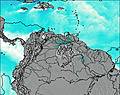
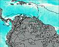
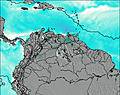
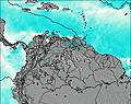
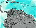
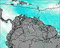
This table gives the weather forecast for Pico Pan de Azúcar at the specific elevation of 4680 m. Our advanced weather models allow us to provide distinct weather forecasts for several elevations of Pico Pan de Azúcar. To see the weather forecasts for the other elevations, use the tab navigation above the table. For a wider overview of the weather, consult the Weather Map of Venezuela.
| Weather Station | Temp. | Weather | Wind | Gusts | Cloud / Visibility |
|---|---|---|---|---|---|
Arauc / antiago Pérez Quiroz Airport | |||||
Cúcut / amilo Daza International Airport | |||||
Barquisimeto Airport | |||||
Valledupa / eropuerto Alfonso López Pumarejo Airport | |||||
Bucaramang / alonegro Airport | |||||
Cor / ose-Leonardo Chirinos Airport | |||||
Paraguan / osefa Camejo International Airport | |||||
Barrancabermej / ariguíes Airport |
* NOTE: not all weather observatories update at the same frequency which is the reason why some locations may show data from stations that are further away than known closer ones.