– Lat/Long: 49.44° N 57.92° W
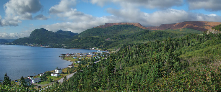
 Pic a Tenerife
Weather Forecast, CanadaIssued: 8 am Mon 03 Aug Local TimeUpdates in: hr min sUpdate imminent
Issued: 8 am Mon 03 Aug Local Time
Updates in:
Update imminent hr min s

Issued: 8 am Mon 03 Aug Local Time
Updates in:
Update imminent hr min s
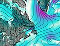
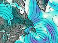
Days 1–3 Weather SummaryHeavy rain (total 23mm), heaviest during Tue afternoon. Warm (max 21°C on Mon afternoon, min 12°C on Tue night). Winds increasing (calm on Mon morning, near gales from the S by Tue morning). | Days 4–6 Weather SummaryMostly dry. Warm (max 22°C on Thu afternoon, min 15°C on Thu night). Wind will be generally light. | |||||||||||||||||
Monday 3 | Tuesday 4 | Wednesday 5 | Thursday 6 | Friday 7 | Saturday 8 | |||||||||||||
AM | PM | night | AM | PM | night | AM | PM | night | AM | PM | night | AM | PM | night | AM | PM | night | |
some clouds | some clouds | light rain | rain shwrs | rain shwrs | heavy rain | light rain | rain shwrs | clear | clear | clear | clear | some clouds | some clouds | some clouds | some clouds | rain shwrs | light rain | |
Cloud base (m) | 9350 | 5250 | 200 | 200 | 150 | 200 | 250 | 1700 | 5750 | 800 | 2500 | 350 | ||||||
km/h | ||||||||||||||||||
 |  |  |  |  |  | |||||||||||||
— | — | — | — | — | — | — | — | — | — | — | — | — | — | — | — | — | — | |
mm | — | — | 0.8 | 1.2 | 8 | 11 | 1.7 | 0.1 | — | — | — | — | — | — | — | — | 0.3 | 0.2 |
max °C | 20 | 21 | 18 | 19 | 17 | 14 | 13 | 15 | 15 | 21 | 22 | 18 | 21 | 22 | 17 | 19 | 20 | 17 |
min °C | 17 | 21 | 17 | 19 | 16 | 12 | 13 | 14 | 14 | 19 | 21 | 15 | 19 | 21 | 15 | 19 | 16 | 16 |
chill °C | 17 | 21 | 16 | 18 | 14 | 9 | 11 | 12 | 12 | 19 | 21 | 15 | 19 | 21 | 15 | 19 | 16 | 16 |
Freezing level m | 4200 | 4250 | 4550 | 4600 | 4500 | 3200 | 3350 | 3550 | 4000 | 4550 | 4450 | 4500 | 4050 | 3950 | 3900 | 3800 | 3800 | 3950 |
5:54 | — | — | 5:56 | — | — | 5:56 | — | — | 5:58 | — | — | 6:00 | — | — | 6:01 | — | — | |
— | 8:59 | — | — | 8:58 | — | — | 8:55 | — | — | 8:54 | — | — | 8:52 | — | — | 8:51 | — | |
Loading...
Pic a Tenerife Weather (Days 0-3):
The weather forecast for Pic a Tenerife is: Heavy rain (total 23mm), heaviest during Tue afternoon. Warm (max 21°C on Mon afternoon, min 12°C on Tue night). Winds increasing (calm on Mon morning, near gales from the S by Tue morning).
Pic a Tenerife Weather (Days 3-6):
Mostly dry. Warm (max 22°C on Thu afternoon, min 15°C on Thu night). Wind will be generally light.
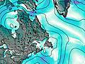
This table gives the weather forecast for Pic a Tenerife at the specific elevation of 545 m. Our advanced weather models allow us to provide distinct weather forecasts for several elevations of Pic a Tenerife. To see the weather forecasts for the other elevations, use the tab navigation above the table. For a wider overview of the weather, consult the Weather Map of Newfoundland.
| Weather Station | Temp. | Weather | Wind | Gusts | Cloud / Visibility |
|---|---|---|---|---|---|
Rocky Harbour Airport | |||||
Rocky Harbour- Nfld | |||||
Deer Lake Airport | |||||
SHIP5781 | |||||
SHIP528 | |||||
SHIP4507 | |||||
SHIP4209 |
* NOTE: not all weather observatories update at the same frequency which is the reason why some locations may show data from stations that are further away than known closer ones.
Pic a Tenerife Photos
View all
Appalachians photos (910) |
photos from mountains in Canada (457) |
all photos
 Upload new photo
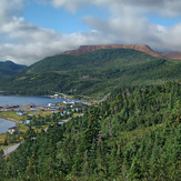
Pic a Tenerife