– Lat/Long: 54.16° N 2.25° W
 Pen-y-ghent
Weather Forecast, United KingdomIssued: 12 pm Mon 03 Aug Local TimeUpdates in: hr min sUpdate imminent
Issued: 12 pm Mon 03 Aug Local Time
Updates in:
Update imminent hr min s

Issued: 12 pm Mon 03 Aug Local Time
Updates in:
Update imminent hr min s
Days 1–3 Weather SummaryLight rain (total 9mm), mostly falling on Tue afternoon. Warm (max 25°C on Mon afternoon, min 12°C on Wed night). Winds increasing (light winds from the E on Mon night, strong winds from the WSW by Wed afternoon). | Days 4–6 Weather SummaryMostly dry. Very mild (max 18°C on Fri morning, min 11°C on Thu night). Wind will be generally light. | |||||||||||||||||
Monday 3 | Tuesday 4 | Wednesday 5 | Thursday 6 | Friday 7 | Saturday 8 | |||||||||||||
AM | PM | night | AM | PM | night | AM | PM | night | AM | PM | night | AM | PM | night | AM | PM | night | |
some clouds | some clouds | light rain | light rain | risk tstorm | rain shwrs | light rain | light rain | light rain | light rain | rain shwrs | some clouds | rain shwrs | some clouds | some clouds | light rain | cloudy | cloudy | |
Cloud base (m) | 2200 | 2300 | 2300 | 600 | 650 | 550 | 350 | 300 | 300 | 700 | 700 | 750 | 450 | 6600 | 6000 | 400 | 1900 | 450 |
km/h | ||||||||||||||||||
 |  |  |  |  |  | |||||||||||||
— | — | — | — | — | — | — | — | — | — | — | — | — | — | — | — | — | — | |
mm | — | — | 0.2 | 0.2 | 3 | 1.1 | 1.6 | 1.5 | 1.7 | 0.2 | 0.5 | — | 0.2 | — | — | 0.1 | — | — |
max °C | 23 | 25 | 17 | 23 | 22 | 17 | 14 | 13 | 13 | 14 | 16 | 12 | 18 | 18 | 13 | 18 | 17 | 15 |
min °C | 18 | 21 | 15 | 19 | 20 | 14 | 13 | 13 | 12 | 14 | 15 | 11 | 15 | 16 | 11 | 16 | 16 | 15 |
chill °C | 17 | 21 | 15 | 19 | 20 | 12 | 10 | 10 | 9 | 13 | 14 | 10 | 14 | 16 | 11 | 15 | 15 | 15 |
Freezing level m | 3100 | 3250 | 3400 | 3600 | 3450 | 3550 | 2950 | 2600 | 2750 | 2400 | 2450 | 2800 | 2650 | 2700 | 2800 | 3200 | 3450 | 3500 |
5:24 | — | — | 5:24 | — | — | 5:26 | — | — | 5:28 | — | — | 5:31 | — | — | 5:31 | — | — | |
— | 9:05 | — | — | 9:02 | — | — | 9:00 | — | — | 8:59 | — | — | 8:57 | — | — | 8:54 | — | |
Loading...
Pen-y-ghent Weather (Days 0-3):
The weather forecast for Pen-y-ghent is: Light rain (total 9mm), mostly falling on Tue afternoon. Warm (max 25°C on Mon afternoon, min 12°C on Wed night). Winds increasing (light winds from the E on Mon night, strong winds from the WSW by Wed afternoon).
Pen-y-ghent Weather (Days 3-6):
Mostly dry. Very mild (max 18°C on Fri morning, min 11°C on Thu night). Wind will be generally light.
This table gives the weather forecast for Pen-y-ghent at the specific elevation of 100 m. Our advanced weather models allow us to provide distinct weather forecasts for several elevations of Pen-y-ghent. To see the weather forecasts for the other elevations, use the tab navigation above the table. For a wider overview of the weather, consult the Weather Map of United Kingdom.
Pen-y-ghent Photos
View all
photos (28) |
Pennines photos (198) |
photos from mountains in United Kingdom (2125) |
all photos
 Upload new photo
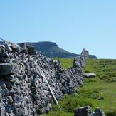
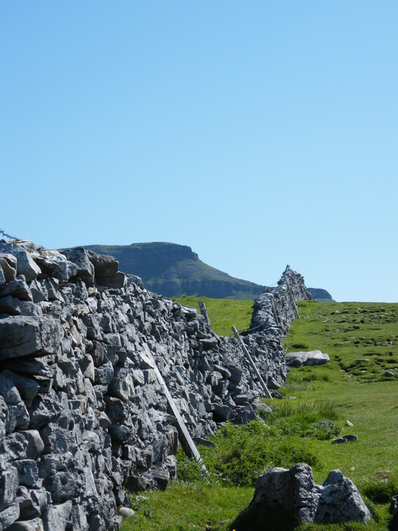
Penyghent in the sunshine
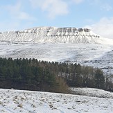
Snow covered Pen-y-ghent
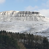
Snow covered Pen-y-ghent