– Lat/Long: 46.42° N 9.95° E
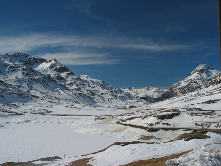
 Munt Pers
Weather Forecast, SwitzerlandIssued: 1 am Fri 17 Jul Local TimeUpdates in: hr min sUpdate imminent
Issued: 1 am Fri 17 Jul Local Time
Updates in:
Update imminent hr min s

Issued: 1 am Fri 17 Jul Local Time
Updates in:
Update imminent hr min s
Days 1–3 Weather SummaryModerate rain (total 14mm), heaviest on Sun afternoon. Very mild (max 13°C on Fri afternoon, min 7°C on Sun night). Wind will be generally light. | Days 4–6 Weather SummaryHeavy rain (total 22mm), heaviest during Wed night. Very mild (max 11°C on Mon afternoon, min 3°C on Wed night). Wind will be generally light. | |||||||||||||||||
Friday 17 | Saturday 18 | Sunday 19 | Monday 20 | Tuesday 21 | Wednesday 22 | |||||||||||||
AM | PM | night | AM | PM | night | AM | PM | night | AM | PM | night | AM | PM | night | AM | PM | night | |
rain shwrs | risk tstorm | risk tstorm | rain shwrs | risk tstorm | risk tstorm | rain shwrs | rain shwrs | rain shwrs | clear | risk tstorm | risk tstorm | rain shwrs | risk tstorm | rain shwrs | clear | clear | rain shwrs | |
km/h | ||||||||||||||||||
 |  |  |  |  |  | |||||||||||||
— | — | — | — | — | — | — | — | — | — | — | — | — | — | — | — | — | — | |
mm | 1.3 | 1.1 | 2 | 0.8 | 3 | 2 | 0.6 | 3 | 0.3 | — | 1 | 2 | 0.7 | 4 | 0.3 | — | — | 13 |
max °C | 11 | 13 | 12 | 10 | 11 | 10 | 10 | 10 | 9 | 9 | 11 | 9 | 8 | 9 | 6 | 7 | 10 | 8 |
min °C | 10 | 13 | 9 | 9 | 10 | 8 | 9 | 8 | 7 | 8 | 10 | 7 | 7 | 7 | 4 | 5 | 9 | 3 |
chill °C | 9 | 12 | 9 | 8 | 9 | 7 | 8 | 6 | 6 | 8 | 9 | 7 | 7 | 4 | 0 | 5 | 9 | 0 |
Freezing level m | 4000 | 4350 | 4100 | 3900 | 4000 | 3950 | 3800 | 3700 | 3850 | 3700 | 3800 | 3700 | 3600 | 3450 | 3400 | 3400 | 3850 | 3200 |
Cloud base (m) | 2950 | 4450 | 2550 | 3450 | 4500 | 2900 | 2850 | 3650 | 3550 | 7100 | 3650 | 2600 | ||||||
5:43 | — | — | 5:43 | — | — | 5:45 | — | — | 5:46 | — | — | 5:48 | — | — | 5:48 | — | — | |
— | — | 9:07 | — | — | 9:07 | — | — | 9:06 | — | — | 9:05 | — | — | 9:04 | — | — | 9:02 | |
Loading...
Munt Pers Weather (Days 0-3):
The weather forecast for Munt Pers is: Moderate rain (total 14mm), heaviest on Sun afternoon. Very mild (max 13°C on Fri afternoon, min 7°C on Sun night). Wind will be generally light.
Munt Pers Weather (Days 3-6):
Heavy rain (total 22mm), heaviest during Wed night. Very mild (max 11°C on Mon afternoon, min 3°C on Wed night). Wind will be generally light.
This table gives the weather forecast for Munt Pers at the specific elevation of 2500 m. Our advanced weather models allow us to provide distinct weather forecasts for several elevations of Munt Pers. To see the weather forecasts for the other elevations, use the tab navigation above the table. For a wider overview of the weather, consult the Weather Map of Switzerland.
| Weather Station | Temp. | Weather | Wind | Gusts | Cloud / Visibility |
|---|---|---|---|---|---|
Lagalb Bergstation | |||||
Piz Corvatsch | |||||
Poschiavo / Robbia | |||||
Muottas Muragl | |||||
thunderstorm affecting Poschiavo | |||||
Samedan Airport | |||||
Sils im Engadi / egl | |||||
lightning 5km ENE of Lanzada |
* NOTE: not all weather observatories update at the same frequency which is the reason why some locations may show data from stations that are further away than known closer ones.
Munt Pers Photos
View all
Bernina Range photos (8) |
Alps photos (1484) |
photos from mountains in Switzerland (649) |
all photos
 Upload new photo
Munt Pers