– Lat/Long: 42.00° S 173.66° E
 Mt Tapuaenuku (Kaikouras)
Weather Forecast, New ZealandIssued: 5 am Tue 04 Aug Local TimeUpdates in: hr min sUpdate imminent
Issued: 5 am Tue 04 Aug Local Time
Updates in:
Update imminent hr min s

Issued: 5 am Tue 04 Aug Local Time
Updates in:
Update imminent hr min s
Days 1–3 Weather SummaryA dusting of new snow. Temperatures will be below freezing (max -4°C on Thu night, min -18°C on Tue morning). Winds decreasing (severe gales from the S on Tue night, light winds from the WNW by Thu night). | Days 4–6 Weather SummaryA moderate fall of snow, heaviest on Sat night. Temperatures will be below freezing (max -3°C on Fri morning, min -9°C on Sun night). Winds decreasing (strong winds from the WNW on Fri afternoon, calm by Sun night). | |||||||||||||||||
Tuesday 4 | Wednesday 5 | Thursday 6 | Friday 7 | Saturday 8 | Sunday 9 | |||||||||||||
AM | PM | night | AM | PM | night | AM | PM | night | AM | PM | night | AM | PM | night | AM | PM | night | |
snow shwrs | snow shwrs | clear | clear | clear | clear | clear | clear | clear | some clouds | cloudy | some clouds | cloudy | light snow | snow shwrs | clear | some clouds | some clouds | |
Cloud base (m) | 600 | 650 | 600 | 850 | 1000 | 650 | 9050 | 3150 | 850 | 3100 | 2250 | 550 | 1700 | 900 | 600 | |||
km/h | ||||||||||||||||||
 |  |  |  |  |  | |||||||||||||
1 | 3 | — | — | — | — | — | — | — | — | — | — | — | 1 | 17 | — | — | — | |
mm | — | — | — | — | — | — | — | — | — | — | — | — | — | — | — | — | — | — |
max °C | -17 | -14 | -10 | -10 | -10 | -9 | -9 | -5 | -4 | -3 | -3 | -3 | -6 | -6 | -6 | -7 | -8 | -9 |
min °C | -18 | -18 | -11 | -10 | -10 | -10 | -9 | -7 | -5 | -3 | -4 | -4 | -6 | -6 | -7 | -7 | -8 | -9 |
chill °C | -34 | -34 | -26 | -20 | -20 | -20 | -18 | -14 | -10 | -10 | -13 | -12 | -10 | -15 | -17 | -15 | -14 | -9 |
Freezing level m | 650 | 550 | 350 | 650 | 1150 | 750 | 1100 | 1450 | 1850 | 2250 | 2300 | 2300 | 2050 | 1950 | 1500 | 1700 | 1650 | 1400 |
7:31 | — | — | 7:31 | — | — | 7:30 | — | — | 7:28 | — | — | 7:26 | — | — | 7:26 | — | — | |
— | 5:30 | — | — | 5:30 | — | — | 5:31 | — | — | 5:32 | — | — | 5:34 | — | — | 5:35 | — | |
Loading...
Mt Tapuaenuku (Kaikouras) Weather (Days 0-3):
The weather forecast for Mt Tapuaenuku (Kaikouras) is: A dusting of new snow. Temperatures will be below freezing (max -4°C on Thu night, min -18°C on Tue morning). Winds decreasing (severe gales from the S on Tue night, light winds from the WNW by Thu night).
Mt Tapuaenuku (Kaikouras) Weather (Days 3-6):
A moderate fall of snow, heaviest on Sat night. Temperatures will be below freezing (max -3°C on Fri morning, min -9°C on Sun night). Winds decreasing (strong winds from the WNW on Fri afternoon, calm by Sun night).
This table gives the weather forecast for Mt Tapuaenuku (Kaikouras) at the specific elevation of 2885 m. Our advanced weather models allow us to provide distinct weather forecasts for several elevations of Mt Tapuaenuku (Kaikouras). To see the weather forecasts for the other elevations, use the tab navigation above the table. For a wider overview of the weather, consult the Weather Map of New Zealand.
| Weather Station | Temp. | Weather | Wind | Gusts | Cloud / Visibility |
|---|---|---|---|---|---|
Mid Awatere Valley | |||||
Tor Darroch | |||||
Upper Clarence | |||||
Ward | |||||
Glenveigh | |||||
Landsdowne | |||||
Booker Road | |||||
Ngaruru | |||||
Pudding Hill | |||||
* NOTE: not all weather observatories update at the same frequency which is the reason why some locations may show data from stations that are further away than known closer ones.
Mt Tapuaenuku (Kaikouras) Photos
View all
Kaikoura Ranges photos (3) |
New Zealand photos (156) |
photos from mountains in New Zealand (160) |
all photos
 Upload new photo
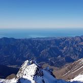
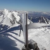
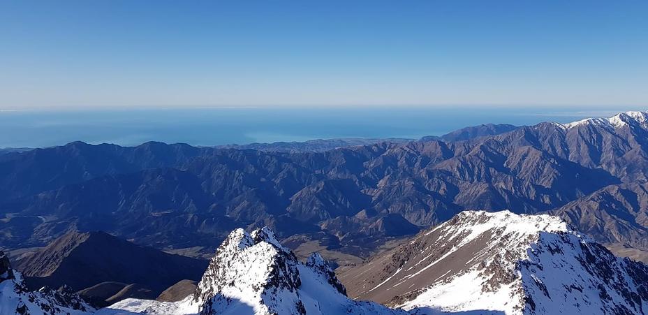
Summit view
Looking down from near top of Mt Tapuaenuku on March 8th 2014
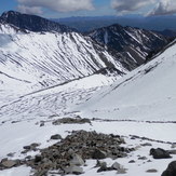
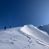
Going Down Mt Tapuaenuku 08.03.14
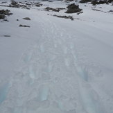
Sumit ridge