Mt Jefferson Climbing Notes

Mt Jefferson climbing notes shared by Mountain-Forecast users
Click here to submit your own climbing note for Mt Jefferson
(NOTE: Texts may be edited by our content team for the purposes of ensuring accurate and relevant information)
-
September 24, 2016
Bart L Schairer from United States
What follows pertains to a Mt. Jefferson approach from the west side, starting and returning to the (ample) parking at Jefferson Notch (along Jefferson Notch Road). I am unfamiliar with any approaches from the east side, so I cannot speak to those approaches. I took the Caps Ridge Trail to the summit of Jefferson, and then took the Castle trail down to The Link, which took me back to the Caps Ridge Trail which took me back to the parking at Jefferson Notch. I was told by two different AMC people that most people take the Caps Ridge up and back because “The Link SUCKS”, but since neither were very descriptive of why it sucked, I took that way back.
At least as pertains to these trails this website’s difficulty rating of “Walk Up” is a bit misleading. The day I did Jefferson two different couples turned back once they got to the first of the three Caps on the Caps Ridge trail, because once you get to that point it’s a bit more than just a ‘walk up’. For an experienced climber and/or someone in good physical condition this route is not a problem, but inexperience and/or poor physical condition can cause fear to creep in once one looks at those Caps to be conquered. The Caps are three rock formations that need to be climbed, and while it was a dry day when I did it I’m not sure I would want to do it on a wet day (call me a coward if you must). Due to my 55 year-old knees and the fact fatigue was a factor (since I work graveyard shift fatigue is always a factor) I didn’t want to come back that way, hoping that the Castle Trail would have less of an impact on my knees on the descent, but that turned out not to be true.
The ‘Castles’ on the Castle Trail are also rock formations and since I was descending them rather than ascending, I can’t properly compare them to the Caps. What I can say is that for 55 year-old knees carrying a 50 lb. pack (since I’m climbing alone I always pack lots of food, water, and clothing in the event that I do something stupid like get lost or break a leg and have to spend the night on the mountain) the drops down from ledges and from jumping down from boulder to boulder were painful and took lots of the fun out of it. Twenty years ago, when my knees weren’t an issue and I wasn’t yet working graveyard shift, I would have found all three of these trails exciting and exhilarating, as well as challenging. I still enjoyed this trip, but on older knees it causes a bit of a beating. I used hiking poles to take some of the descent weight off of my knees, but I frequently had to put them away to use my arms to hang off of ledges and sometimes trees to drop down to the next level of the Castle Trail. Again, if I wasn’t carrying so much weight and my knees weren’t an issue, I may have remembered this descent differently, but I write this to let those who might not be physically up to this know what to expect.
Once I finally got to The Link I thought I would be entering a fairly level section, as it deceptively looks that way on the map, and I had previously gone in on The Link a bit from the south side, when I was there earlier, and it is level and nice on the south end. But coming in on the northern end is more challenging – not impossible, but challenging. I now know why I was told this section of trail sucks – it even has snowless crevasses! I found that in places there are large rocks with spaces between them large enough to at least swallow a leg, but since tree roots have grown over them pine needles have amassed and are hiding the trap underneath. Once I had almost stepped into one, I spent the rest of the trip poking everything that wasn’t definitively solid rock with the hiking poles to ascertain what was underneath. At one point I got my foot stuck between two large tree roots and as it took a bit of doing to get my foot out (without falling over the skinny ledge I was on) I momentarily regretted leaving my large knife out of my pack to save on weight.
The Link is not at all level on the northern end, and is a constant up and down as you are heading south. If you are tired at this point this can be very discouraging, since you’re thinking you should be going down to get back to where you started, but The Link likes to crush your optimism at every turn. Again, twenty years ago I probably would have loved this section of trail, but my old knees and my tired body just wanted to get back to Jefferson Notch, and the Link doesn’t like to make it easy.
I was told that the Link is very well marked, making getting lost impossible, and for the most part this is true. Only in the two most dangerous parts did I have to stop and try to figure out where to go next as it wasn’t apparent in these two places (one being a ravine crossing, and the other one I don’t recall). But overall The Link is definitely doable, as long as you are physically up to the challenge.
The loop I took is supposed to take 5¼ hours, but due to fatigue and my old knees it took me 7½ hours (with two 15-minute breaks for food and water). Just something to keep in mind if you’re older like me, and you want to be off the mountain by dark.
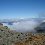
Even if you have no intentions of trying to conquer the Caps or the Castles of Mt. Jefferson, a thirty minute hike up the Caps Ridge Trail will bring you to a boulder outcropping on the south side of Jefferson that gives a wonderful view of the surrounding ravines, valleys, and mountains. This short hike is possible for almost everyone, except those in the worst of physical condition, and the views are worth the effort. You may find yourself staying here for quite a while before you make the thirty minute trip back down.
Access to the western base of Mr. Jefferson is obtained by way of the Jefferson Notch Road. This is a well maintained gravel road (the quality of a good logging road) that is closed in winter. It is very smooth going unless a recent heavy rain has made it a bit ‘washboardy’, but even at that it is better going than the paved Clinton Road that connects to the south at the Base Road, which is a mess of lumps due to freezing and thawing. Because of this, it’s better to turn on Base Road (the road that leads to the Cog Railroad) off of Rt. 16 and take that to Jefferson Road, if you are coming in from the south side. From the north you would just turn onto Jefferson Notch Road from Rt. 2.
(NOTE: Texts may be edited by our content team for the purposes of ensuring accurate and relevant information)
Bart L Schairer from United States
What follows pertains to a Mt. Jefferson approach from the west side, starting and returning to the (ample) parking at Jefferson Notch (along Jefferson Notch Road). I am unfamiliar with any approaches from the east side, so I cannot speak to those approaches. I took the Caps Ridge Trail to the summit of Jefferson, and then took the Castle trail down to The Link, which took me back to the Caps Ridge Trail which took me back to the parking at Jefferson Notch. I was told by two different AMC people that most people take the Caps Ridge up and back because “The Link SUCKS”, but since neither were very descriptive of why it sucked, I took that way back.
At least as pertains to these trails this website’s difficulty rating of “Walk Up” is a bit misleading. The day I did Jefferson two different couples turned back once they got to the first of the three Caps on the Caps Ridge trail, because once you get to that point it’s a bit more than just a ‘walk up’. For an experienced climber and/or someone in good physical condition this route is not a problem, but inexperience and/or poor physical condition can cause fear to creep in once one looks at those Caps to be conquered. The Caps are three rock formations that need to be climbed, and while it was a dry day when I did it I’m not sure I would want to do it on a wet day (call me a coward if you must). Due to my 55 year-old knees and the fact fatigue was a factor (since I work graveyard shift fatigue is always a factor) I didn’t want to come back that way, hoping that the Castle Trail would have less of an impact on my knees on the descent, but that turned out not to be true.
The ‘Castles’ on the Castle Trail are also rock formations and since I was descending them rather than ascending, I can’t properly compare them to the Caps. What I can say is that for 55 year-old knees carrying a 50 lb. pack (since I’m climbing alone I always pack lots of food, water, and clothing in the event that I do something stupid like get lost or break a leg and have to spend the night on the mountain) the drops down from ledges and from jumping down from boulder to boulder were painful and took lots of the fun out of it. Twenty years ago, when my knees weren’t an issue and I wasn’t yet working graveyard shift, I would have found all three of these trails exciting and exhilarating, as well as challenging. I still enjoyed this trip, but on older knees it causes a bit of a beating. I used hiking poles to take some of the descent weight off of my knees, but I frequently had to put them away to use my arms to hang off of ledges and sometimes trees to drop down to the next level of the Castle Trail. Again, if I wasn’t carrying so much weight and my knees weren’t an issue, I may have remembered this descent differently, but I write this to let those who might not be physically up to this know what to expect.
Once I finally got to The Link I thought I would be entering a fairly level section, as it deceptively looks that way on the map, and I had previously gone in on The Link a bit from the south side, when I was there earlier, and it is level and nice on the south end. But coming in on the northern end is more challenging – not impossible, but challenging. I now know why I was told this section of trail sucks – it even has snowless crevasses! I found that in places there are large rocks with spaces between them large enough to at least swallow a leg, but since tree roots have grown over them pine needles have amassed and are hiding the trap underneath. Once I had almost stepped into one, I spent the rest of the trip poking everything that wasn’t definitively solid rock with the hiking poles to ascertain what was underneath. At one point I got my foot stuck between two large tree roots and as it took a bit of doing to get my foot out (without falling over the skinny ledge I was on) I momentarily regretted leaving my large knife out of my pack to save on weight.
The Link is not at all level on the northern end, and is a constant up and down as you are heading south. If you are tired at this point this can be very discouraging, since you’re thinking you should be going down to get back to where you started, but The Link likes to crush your optimism at every turn. Again, twenty years ago I probably would have loved this section of trail, but my old knees and my tired body just wanted to get back to Jefferson Notch, and the Link doesn’t like to make it easy.
I was told that the Link is very well marked, making getting lost impossible, and for the most part this is true. Only in the two most dangerous parts did I have to stop and try to figure out where to go next as it wasn’t apparent in these two places (one being a ravine crossing, and the other one I don’t recall). But overall The Link is definitely doable, as long as you are physically up to the challenge.
The loop I took is supposed to take 5¼ hours, but due to fatigue and my old knees it took me 7½ hours (with two 15-minute breaks for food and water). Just something to keep in mind if you’re older like me, and you want to be off the mountain by dark.
Even if you have no intentions of trying to conquer the Caps or the Castles of Mt. Jefferson, a thirty minute hike up the Caps Ridge Trail will bring you to a boulder outcropping on the south side of Jefferson that gives a wonderful view of the surrounding ravines, valleys, and mountains. This short hike is possible for almost everyone, except those in the worst of physical condition, and the views are worth the effort. You may find yourself staying here for quite a while before you make the thirty minute trip back down.
Access to the western base of Mr. Jefferson is obtained by way of the Jefferson Notch Road. This is a well maintained gravel road (the quality of a good logging road) that is closed in winter. It is very smooth going unless a recent heavy rain has made it a bit ‘washboardy’, but even at that it is better going than the paved Clinton Road that connects to the south at the Base Road, which is a mess of lumps due to freezing and thawing. Because of this, it’s better to turn on Base Road (the road that leads to the Cog Railroad) off of Rt. 16 and take that to Jefferson Road, if you are coming in from the south side. From the north you would just turn onto Jefferson Notch Road from Rt. 2.