– Lat/Long: 45.90° N 68.92° W
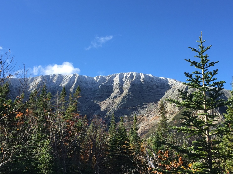
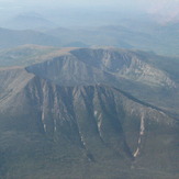
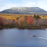
 Mount Katahdin
Weather Forecast, United StatesIssued: 7 am Mon 03 Aug Local TimeUpdates in: hr min sUpdate imminent
Issued: 7 am Mon 03 Aug Local Time
Updates in:
Update imminent hr min s

Issued: 7 am Mon 03 Aug Local Time
Updates in:
Update imminent hr min s
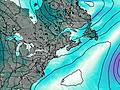
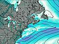
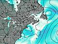
Days 1–3 Weather SummaryHeavy rain (total 23mm), heaviest during Mon afternoon. Warm (max 23°C on Wed afternoon, min 11°C on Mon night). Winds decreasing (stormy winds from the WNW on Mon night, light winds from the WSW by Wed morning). | Days 4–6 Weather SummaryMostly dry. Warm (max 23°C on Thu afternoon, min 18°C on Fri night). Wind will be generally light. | |||||||||||||||||
Monday 3 | Tuesday 4 | Wednesday 5 | Thursday 6 | Friday 7 | Saturday 8 | |||||||||||||
AM | PM | night | AM | PM | night | AM | PM | night | AM | PM | night | AM | PM | night | AM | PM | night | |
light rain | heavy rain | rain shwrs | clear | clear | clear | clear | clear | clear | clear | clear | some clouds | rain shwrs | risk tstorm | clear | clear | clear | clear | |
Cloud base (m) | 450 | 350 | 400 | 8600 | 5450 | 9650 | 3150 | 2000 | ||||||||||
km/h | ||||||||||||||||||
 |  |  |  |  |  | |||||||||||||
— | — | — | — | — | — | — | — | — | — | — | — | — | — | — | — | — | — | |
mm | 3 | 12 | 8 | — | — | — | — | — | — | — | — | — | 0.1 | 0.8 | — | — | — | — |
max °C | 17 | 18 | 17 | 15 | 18 | 17 | 21 | 23 | 20 | 20 | 23 | 21 | 21 | 22 | 20 | 20 | 23 | 21 |
min °C | 16 | 17 | 11 | 14 | 18 | 16 | 19 | 22 | 17 | 19 | 23 | 20 | 21 | 21 | 18 | 19 | 23 | 18 |
chill °C | 14 | 15 | 6 | 10 | 16 | 14 | 19 | 22 | 16 | 19 | 23 | 20 | 21 | 21 | 18 | 19 | 23 | 18 |
Freezing level m | 4500 | 4600 | 3350 | 4000 | 4600 | 4700 | 4650 | 4750 | 4800 | 4750 | 4800 | 4550 | 4450 | 4600 | 4300 | 4250 | 4250 | 4300 |
5:20 | — | — | 5:20 | — | — | 5:22 | — | — | 5:22 | — | — | 5:24 | — | — | 5:26 | — | — | |
— | — | 8:01 | — | — | 8:00 | — | — | 8:00 | — | 7:58 | — | — | 7:57 | — | — | 7:54 | — | |
Loading...
Mount Katahdin Weather (Days 0-3):
The weather forecast for Mount Katahdin is: Heavy rain (total 23mm), heaviest during Mon afternoon. Warm (max 23°C on Wed afternoon, min 11°C on Mon night). Winds decreasing (stormy winds from the WNW on Mon night, light winds from the WSW by Wed morning).
Mount Katahdin Weather (Days 3-6):
Mostly dry. Warm (max 23°C on Thu afternoon, min 18°C on Fri night). Wind will be generally light.
This table gives the weather forecast for Mount Katahdin at the specific elevation of 1000 m. Our advanced weather models allow us to provide distinct weather forecasts for several elevations of Mount Katahdin. To see the weather forecasts for the other elevations, use the tab navigation above the table. For a wider overview of the weather, consult the Weather Map of Maine.
| Weather Station | Temp. | Weather | Wind | Gusts | Cloud / Visibility |
|---|---|---|---|---|---|
Greenville Airport | |||||
Clayton Lake | |||||
* NOTE: not all weather observatories update at the same frequency which is the reason why some locations may show data from stations that are further away than known closer ones.
Mount Katahdin Photos
View all
Longfellow Mountains photos (31) |
Appalachians photos (910) |
photos from mountains in United States (3056) |
all photos
 Upload new photo
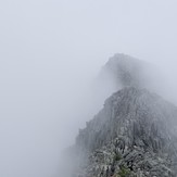
 See 17 more Mount Katahdin photos
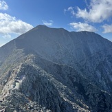
The Knife Edge
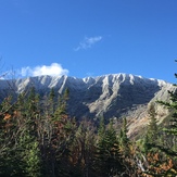
Katahdin
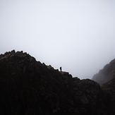
Frosty Tips
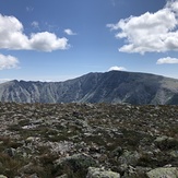
Mount Katahdin
Mount Katahdin
Mt Katahdin 10/11/19