
– Lat/Long: 42.17° S 145.58° E
 Mount Jukes (Tasmania)
Weather Forecast, AustraliaIssued: 3 am Mon 03 Aug Local TimeUpdates in: hr min sUpdate imminent
Issued: 3 am Mon 03 Aug Local Time
Updates in:
Update imminent hr min s

Issued: 3 am Mon 03 Aug Local Time
Updates in:
Update imminent hr min s
Days 1–3 Weather SummaryA moderate fall of snow, heaviest on Mon night. Freeze-thaw conditions (max 4°C on Wed morning, min 0°C on Mon afternoon). Winds decreasing (fresh winds from the NNW on Mon morning, calm by Tue afternoon). | Days 4–6 Weather SummaryLight rain (total 4mm), mostly falling on Sat night. Freeze-thaw conditions (max 4°C on Sat morning, min -1°C on Thu night). Winds increasing (light winds from the WNW on Fri morning, gales from the N by Sat night). | |||||||||||||||||
Monday 3 | Tuesday 4 | Wednesday 5 | Thursday 6 | Friday 7 | Saturday 8 | |||||||||||||
AM | PM | night | AM | PM | night | AM | PM | night | AM | PM | night | AM | PM | night | AM | PM | night | |
light snow | light snow | heavy snow | cloudy | some clouds | clear | clear | clear | some clouds | rain shwrs | rain shwrs | some clouds | some clouds | clear | some clouds | cloudy | cloudy | light rain | |
Cloud base (m) | 300 | 600 | 150 | 200 | 400 | 1750 | 350 | 350 | 250 | 650 | 700 | 700 | 550 | 6150 | 1550 | 750 | ||
km/h | ||||||||||||||||||
 |  |  |  |  |  | |||||||||||||
1 | 2 | 11 | — | — | — | — | — | — | — | — | — | — | — | — | — | — | — | |
mm | — | — | — | — | — | — | — | — | — | 0.3 | 1.5 | — | — | — | — | — | — | 3 |
max °C | 1 | 1 | 1 | 1 | 1 | 1 | 4 | 3 | 1 | 2 | 3 | 0 | 1 | 1 | 2 | 4 | 4 | 3 |
min °C | 1 | 0 | 0 | 1 | 1 | 1 | 3 | 2 | 1 | 1 | 1 | -1 | 0 | 1 | 0 | 3 | 3 | 2 |
chill °C | -5 | -5 | -5 | -2 | -1 | -1 | 2 | -1 | -3 | -4 | -5 | -6 | -4 | -3 | -6 | -3 | -4 | -6 |
Freezing level m | 1300 | 1300 | 1200 | 1300 | 1400 | 1400 | 1750 | 1750 | 1300 | 1300 | 1700 | 1000 | 1250 | 1300 | 1200 | 1800 | 1850 | 1650 |
7:26 | — | — | 7:24 | — | — | 7:24 | — | — | 7:22 | — | — | 7:20 | — | — | 7:20 | — | — | |
— | 5:21 | — | — | 5:22 | — | — | 5:22 | — | — | 5:23 | — | — | 5:24 | — | — | 5:25 | — | |
Loading...
Mount Jukes (Tasmania) Weather (Days 0-3):
The weather forecast for Mount Jukes (Tasmania) is: A moderate fall of snow, heaviest on Mon night. Freeze-thaw conditions (max 4°C on Wed morning, min 0°C on Mon afternoon). Winds decreasing (fresh winds from the NNW on Mon morning, calm by Tue afternoon).
Mount Jukes (Tasmania) Weather (Days 3-6):
Light rain (total 4mm), mostly falling on Sat night. Freeze-thaw conditions (max 4°C on Sat morning, min -1°C on Thu night). Winds increasing (light winds from the WNW on Fri morning, gales from the N by Sat night).
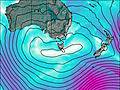
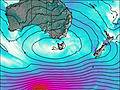
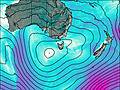
This table gives the weather forecast for Mount Jukes (Tasmania) at the specific elevation of 1168 m. Our advanced weather models allow us to provide distinct weather forecasts for several elevations of Mount Jukes (Tasmania). To see the weather forecasts for the other elevations, use the tab navigation above the table. For a wider overview of the weather, consult the Weather Map of Tasmania.
| Weather Station | Temp. | Weather | Wind | Gusts | Cloud / Visibility |
|---|---|---|---|---|---|
Cape Sorell | |||||
Mount Read | |||||
Sheffield School Farm | |||||
Luncheon Hill (Forestry) | |||||
Bushy Park (Bushy Park Estates) | |||||
lightning 6km W of Westbury |
* NOTE: not all weather observatories update at the same frequency which is the reason why some locations may show data from stations that are further away than known closer ones.