
– Lat/Long: 31.59° S 159.07° E
 Mount Gower (Lord Howe Island)
Weather Forecast, AustraliaIssued: 9 pm Sat 18 Jul Local TimeUpdates in: hr min sUpdate imminent
Issued: 9 pm Sat 18 Jul Local Time
Updates in:
Update imminent hr min s

Issued: 9 pm Sat 18 Jul Local Time
Updates in:
Update imminent hr min s
Days 1–4 Weather SummaryLight rain (total 5mm), mostly falling on Sat night. Very mild (max 12°C on Sat night, min 9°C on Mon night). Winds decreasing (gales from the ESE on Sat night, light winds from the ESE by Tue afternoon). | Days 5–7 Weather SummaryLight rain (total 4mm), mostly falling on Thu morning. Very mild (max 11°C on Tue night, min 7°C on Thu night). Winds increasing (light winds from the NNW on Wed afternoon, near gales from the S by Thu night). | ||||||||||||||||||
Sunday 19 | Monday 20 | Tuesday 21 | Wednesday 22 | Thursday 23 | Friday 24 | ||||||||||||||
night | AM | PM | night | AM | PM | night | AM | PM | night | AM | PM | night | AM | PM | night | AM | PM | night | |
rain shwrs | rain shwrs | rain shwrs | rain shwrs | rain shwrs | rain shwrs | light rain | rain shwrs | rain shwrs | rain shwrs | light rain | rain shwrs | some clouds | rain shwrs | rain shwrs | rain shwrs | rain shwrs | some clouds | rain shwrs | |
Cloud base (m) | 700 | 1700 | 2850 | 450 | 400 | 800 | 350 | 750 | 8750 | 550 | 500 | 750 | 900 | 450 | 550 | 750 | 700 | ||
km/h | |||||||||||||||||||
 |  |  |  |  |  |  | |||||||||||||
— | — | — | — | — | — | — | — | — | — | — | — | — | — | — | — | — | — | — | |
mm | 3 | 0.3 | 0.5 | 0.5 | 0.1 | 0.2 | 0.8 | 0.1 | 0.1 | 0.1 | 0.2 | 0.1 | — | 1.5 | 0.3 | 1.3 | 0.2 | — | 0.4 |
max °C | 12 | 12 | 12 | 12 | 11 | 11 | 10 | 11 | 10 | 11 | 9 | 10 | 11 | 11 | 11 | 10 | 7 | 8 | 9 |
min °C | 12 | 12 | 12 | 10 | 11 | 10 | 9 | 10 | 10 | 9 | 9 | 10 | 10 | 11 | 11 | 7 | 7 | 7 | 7 |
chill °C | 8 | 8 | 8 | 6 | 8 | 6 | 5 | 7 | 8 | 6 | 6 | 8 | 8 | 8 | 8 | 1 | 2 | 2 | 3 |
Freezing level m | 2950 | 2950 | 3000 | 3250 | 3350 | 3350 | 3450 | 3600 | 3650 | 3650 | 3550 | 3350 | 3150 | 2600 | 2550 | 2300 | 1900 | 2000 | 2800 |
— | 6:20 | — | — | 6:18 | — | — | 6:18 | — | — | 6:18 | — | — | 6:18 | — | — | 6:16 | — | — | |
— | — | 4:38 | — | — | 4:39 | — | — | 4:40 | — | — | 4:40 | — | — | 4:42 | — | — | 4:42 | — | |
Loading...
Mount Gower (Lord Howe Island) Weather (Days 0-3):
The weather forecast for Mount Gower (Lord Howe Island) is: Light rain (total 5mm), mostly falling on Sat night. Very mild (max 12°C on Sat night, min 9°C on Mon night). Winds decreasing (gales from the ESE on Sat night, light winds from the ESE by Tue afternoon).
Mount Gower (Lord Howe Island) Weather (Days 3-6):
Light rain (total 4mm), mostly falling on Thu morning. Very mild (max 11°C on Tue night, min 7°C on Thu night). Winds increasing (light winds from the NNW on Wed afternoon, near gales from the S by Thu night).
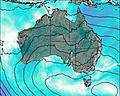
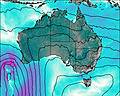
This table gives the weather forecast for Mount Gower (Lord Howe Island) at the specific elevation of 875 m. Our advanced weather models allow us to provide distinct weather forecasts for several elevations of Mount Gower (Lord Howe Island). To see the weather forecasts for the other elevations, use the tab navigation above the table. For a wider overview of the weather, consult the Weather Map of Australia.
| Weather Station | Temp. | Weather | Wind | Gusts | Cloud / Visibility |
|---|---|---|---|---|---|
Lord Howe Island Aero | |||||
lightning | |||||
lightning | |||||
lightning | |||||
Coffs Harbour Airport | |||||
Yamba Pilot Station | |||||
* NOTE: not all weather observatories update at the same frequency which is the reason why some locations may show data from stations that are further away than known closer ones.