– Lat/Long: 42.60° N 1.36° E
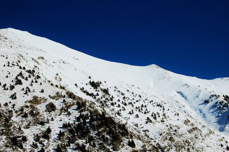
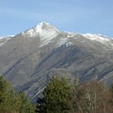
 Monteixo
Weather Forecast, SpainIssued: 1 pm Tue 23 Jun Local TimeUpdates in: hr min sUpdate imminent
Issued: 1 pm Tue 23 Jun Local Time
Updates in:
Update imminent hr min s

Issued: 1 pm Tue 23 Jun Local Time
Updates in:
Update imminent hr min s
Days 1–4 Weather SummaryMostly dry. Warm (max 27°C on Tue afternoon, min 17°C on Thu night). Wind will be generally light. | Days 5–7 Weather SummaryLight rain (total 4mm), mostly falling on Sun night. Warm (max 27°C on Sat afternoon, min 14°C on Sun night). Wind will be generally light. | ||||||||||||||||
Tue 23 | Wednesday 24 | Thursday 25 | Friday 26 | Saturday 27 | Sunday 28 | ||||||||||||
PM | night | AM | PM | night | AM | PM | night | AM | PM | night | AM | PM | night | AM | PM | night | |
some clouds | clear | clear | some clouds | risk tstorm | clear | rain shwrs | clear | clear | clear | clear | clear | clear | clear | clear | rain shwrs | risk tstorm | |
km/h | |||||||||||||||||
 |  |  |  |  |  | ||||||||||||
— | — | — | — | — | — | — | — | — | — | — | — | — | — | — | — | — | |
mm | — | — | — | — | 0.8 | — | 0.1 | — | — | — | — | — | — | — | — | 0.7 | 3 |
max °C | 27 | 24 | 25 | 27 | 19 | 23 | 25 | 22 | 24 | 26 | 24 | 24 | 27 | 25 | 23 | 24 | 20 |
min °C | 26 | 20 | 21 | 25 | 18 | 19 | 25 | 17 | 19 | 26 | 17 | 19 | 26 | 16 | 18 | 24 | 14 |
chill °C | 26 | 20 | 21 | 25 | 18 | 19 | 25 | 17 | 19 | 26 | 17 | 19 | 26 | 16 | 18 | 24 | 14 |
Freezing level m | 4650 | 4600 | 4500 | 4600 | 4600 | 4500 | 4600 | 4600 | 4550 | 4700 | 4700 | 4600 | 4700 | 4550 | 4450 | 4600 | 4550 |
Cloud base (m) | 4300 | 4300 | 8500 | 4250 | 4400 | 4650 | 4500 | 3050 | |||||||||
— | — | 6:16 | — | — | 6:16 | — | — | 6:18 | — | — | 6:18 | — | — | 6:18 | — | — | |
— | 9:36 | — | — | 9:36 | — | — | 9:36 | — | — | 9:36 | — | — | 9:36 | — | — | 9:36 | |
Loading...
Monteixo Weather (Days 0-3):
The weather forecast for Monteixo is: Mostly dry. Warm (max 27°C on Tue afternoon, min 17°C on Thu night). Wind will be generally light.
Monteixo Weather (Days 3-6):
Light rain (total 4mm), mostly falling on Sun night. Warm (max 27°C on Sat afternoon, min 14°C on Sun night). Wind will be generally light.
This table gives the weather forecast for Monteixo at the specific elevation of 1500 m. Our advanced weather models allow us to provide distinct weather forecasts for several elevations of Monteixo. To see the weather forecasts for the other elevations, use the tab navigation above the table. For a wider overview of the weather, consult the Weather Map of Spain.
| Weather Station | Temp. | Weather | Wind | Gusts | Cloud / Visibility |
|---|---|---|---|---|---|
lightning 16km NW of Sort | |||||
Cap del Rec | |||||
lightning 18km WSW of la Seu d'Urgell | |||||
lightning 11km SSW of Toloriu | |||||
Saint Girons |
* NOTE: not all weather observatories update at the same frequency which is the reason why some locations may show data from stations that are further away than known closer ones.
Monteixo Photos
View all
photos (101) |
Pyrenees photos (143) |
photos from mountains in Spain (451) |
all photos
 Upload new photo
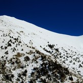
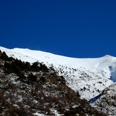
Monteixo Hiver (2)
Monteixo en hiver
Monteixo