– Lat/Long: 42.80° N 1.09° E
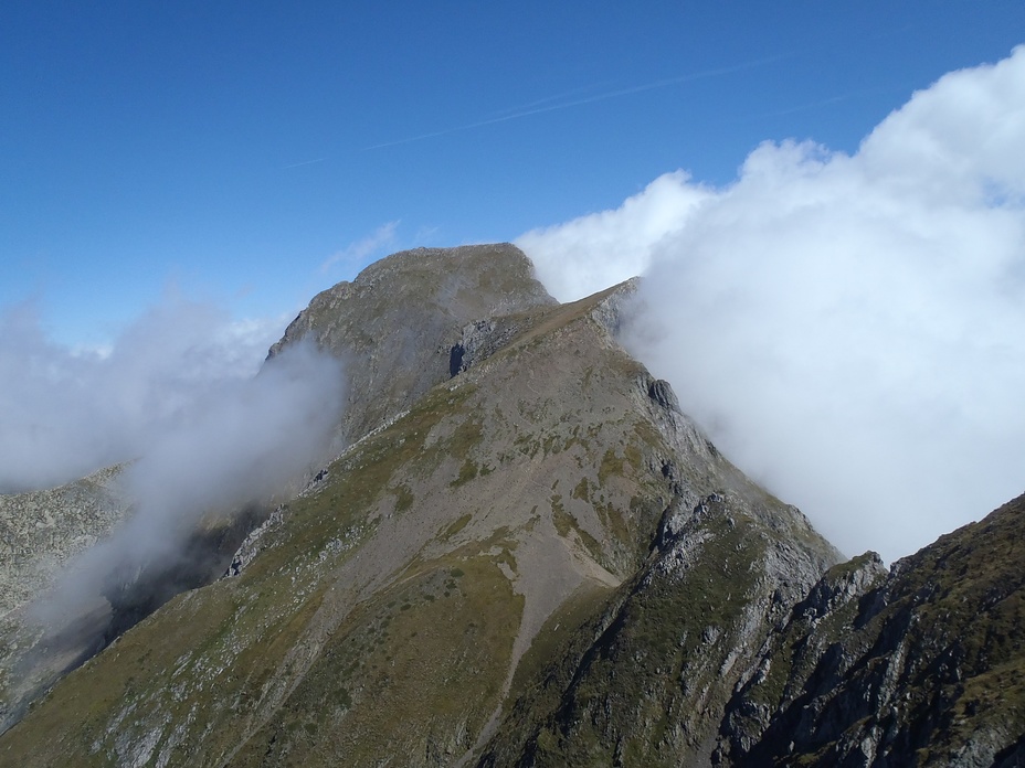
 Mont Valier
Weather Forecast, FranceIssued: 7 pm Sun 19 Jul Local TimeUpdates in: hr min sUpdate imminent
Issued: 7 pm Sun 19 Jul Local Time
Updates in:
Update imminent hr min s

Issued: 7 pm Sun 19 Jul Local Time
Updates in:
Update imminent hr min s
Days 1–4 Weather SummaryMostly dry. Very mild (max 19°C on Wed afternoon, min 12°C on Sun night). Mainly fresh winds. | Days 5–7 Weather SummaryMostly dry. Very mild (max 19°C on Fri afternoon, min 15°C on Wed night). Mainly fresh winds. | ||||||||||||||||||
Monday 20 | Tuesday 21 | Wednesday 22 | Thursday 23 | Friday 24 | Saturday 25 | ||||||||||||||
night | AM | PM | night | AM | PM | night | AM | PM | night | AM | PM | night | AM | PM | night | AM | PM | night | |
risk tstorm | clear | clear | clear | clear | some clouds | clear | clear | some clouds | some clouds | clear | clear | clear | clear | clear | clear | clear | clear | clear | |
Cloud base (m) | 7500 | 9400 | 5200 | 9450 | 5250 | 5450 | 6250 | 5250 | 8050 | 9650 | |||||||||
km/h | |||||||||||||||||||
 |  |  |  |  |  |  | |||||||||||||
— | — | — | — | — | — | — | — | — | — | — | — | — | — | — | — | — | — | — | |
mm | 0.4 | — | — | — | — | — | — | — | — | — | — | — | — | — | — | — | — | — | — |
max °C | 15 | 16 | 18 | 17 | 16 | 18 | 17 | 16 | 19 | 17 | 16 | 17 | 16 | 17 | 19 | 18 | 16 | 16 | 14 |
min °C | 12 | 14 | 17 | 14 | 15 | 18 | 15 | 15 | 18 | 15 | 15 | 17 | 15 | 15 | 18 | 15 | 15 | 16 | 12 |
chill °C | 10 | 12 | 16 | 13 | 13 | 17 | 14 | 14 | 18 | 13 | 13 | 16 | 13 | 14 | 18 | 13 | 13 | 15 | 10 |
Freezing level m | 4400 | 4500 | 4600 | 4650 | 4700 | 4800 | 4750 | 4650 | 4850 | 4800 | 4700 | 4700 | 4950 | 5000 | 5050 | 5050 | 4800 | 4750 | 4750 |
— | 6:33 | — | — | 6:35 | — | — | 6:35 | — | — | 6:37 | — | — | 6:37 | — | — | 6:39 | — | — | |
— | — | — | 9:28 | — | — | 9:28 | — | — | 9:27 | — | — | 9:25 | — | — | 9:24 | — | — | 9:23 | |
Loading...
Mont Valier Weather (Days 0-3):
The weather forecast for Mont Valier is: Mostly dry. Very mild (max 19°C on Wed afternoon, min 12°C on Sun night). Mainly fresh winds.
Mont Valier Weather (Days 3-6):
Mostly dry. Very mild (max 19°C on Fri afternoon, min 15°C on Wed night). Mainly fresh winds.
This table gives the weather forecast for Mont Valier at the specific elevation of 2500 m. Our advanced weather models allow us to provide distinct weather forecasts for several elevations of Mont Valier. To see the weather forecasts for the other elevations, use the tab navigation above the table. For a wider overview of the weather, consult the Weather Map of France.
* NOTE: not all weather observatories update at the same frequency which is the reason why some locations may show data from stations that are further away than known closer ones.
Mont Valier Photos
View all
photos (101) |
Pyrenees photos (143) |
photos from mountains in France (301) |
all photos
 Upload new photo
Mont Valier from the south